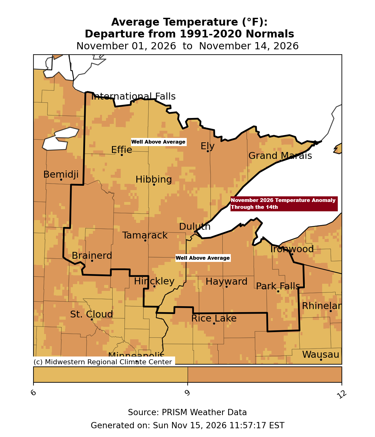
Average temperatures across the Northland this month are still running 7 to more than 9 degrees above normal, even after the recent stretch of cooler weather. In fact, the month-to-date average temperature in Duluth, Hibbing, International Falls, Brainerd, and Ashland remains higher than each location’s warmest November average on record. With a few weeks still remaining in November 2026, it will be interesting to see where we ultimately finish.
November 2026 temperature anomalies up to the 14th
Hibbing, MN: +9.6 degrees
International Falls, MN: +8.5 degrees
Ashland, WI: +8.0 degrees
Brainerd, MN: +7.8 degrees
Duluth, MN: +7.8 degrees
Here’s a look at the warmest November on record and the year it occurred
Ashland, WI: Warmest 42.0 degrees set in 2001
2026 average thru the 14th: 43.9 degrees
Duluth, MN: Warmest 40.6 degrees set in 1899
2026 average thru the 14th: 41.5 degrees
Brainerd, MN: Warmest 40.1 degrees set in 2001
2026 average thru the 14th: 42.4 degrees
International Falls, MN: Warmest 37.2 degrees set in 2016
2026 average thru the 14th: 39.0 degrees
Hibbing, MN: Warmest 35.8 degrees set in 2001
2026 average thru the 14th: 39.2 degrees
But it’s not just the Northland experiencing a mild November—nearly the entire lower 48 states are seeing above-average temperatures this month.

It was a brisk morning across the Northland, with Hog Creek, MN, recording the lowest temperature at 12 degrees, closely followed by Minong, WI, at 13 degrees.
The next few mornings, while still cool—it is November, after all—are expected to be milder than the recent chilly ones.

Temperatures this afternoon rose comfortably into the 40s and lower 50s, about 10 to 15 degrees above the typical November 15th averages.
Expect similar conditions over the next few days, with highs mostly in the 40s and 50s.

…Precipitation Trends…
Areas shown in green and blue on the image below indicate above-average precipitation for the month through the 14th, while yellow, brown, and red areas indicate below-average precipitation.

The week begins dry across northeast Minnesota and northwest Wisconsin, but two low-pressure systems are expected to influence our weather mid- to late-week.
The first system moves through Wednesday night into Thursday, with low pressure tracking well northwest of our area. This keeps us on the warmer side, so any precipitation is expected to fall as rain, although overall rainfall amounts currently appear minimal.

A second system could affect the Northland from Friday night into early Sunday. However, current indications suggest the storm will track northwest of the region, keeping much of the area on the warmer side of the system. As a result, rain appears likely to be the primary precipitation type. Some colder air wrapping into the backside of the low could lead to a brief period of snow or a rain-snow mix in parts of the Northland from Saturday into early Sunday. At this time, though, the projected storm track does not support a significant snow event for our area.
Here is the GEFS 20-member ensemble forecast for precipitation types, valid at 6 AM on Saturday, November 21, 2026.
Rain – green
Blue – snow

…Snowfall Trends…
As of November 15, 2026, Duluth has yet to record its first measurable snowfall (0.1 inch or more).
Here’s a look at the latest date for the first measurable snowfall (0.1 inch or more) in Duluth, based on records dating back to 1948.
1: November 26, 2004
2: November 25, 1964
3: November 24, 1963
4: November 23, 1999
Based on the 20 GEFS ensemble members, only approximately two project Duluth receiving its first measurable snowfall by November 22. Consequently, the likelihood of snow occurring before that date is low.

Leave a Reply