The next few days will bring a colder stretch of weather to the Northland, with the coldest temperatures expected on Monday. After that, temperatures appear likely to moderate again. While the warmups may not be as impressive as some we’ve seen this month, several days with highs in the 30s are possible, and some locations could even reach the 40s by month’s end. So, if you’re a fan of winter-like weather, enjoy the chill while it lasts because it probably won’t stick around for very long.
After Sunday’s system moves through, the week ahead looks pretty quiet across the Northland. There are currently no indications of any major winter storms impacting northeast Minnesota or northwest Wisconsin over the next 5 to 7 days, which should make for a fairly uneventful stretch of late-November weather.
…Sunday Snow Chance…
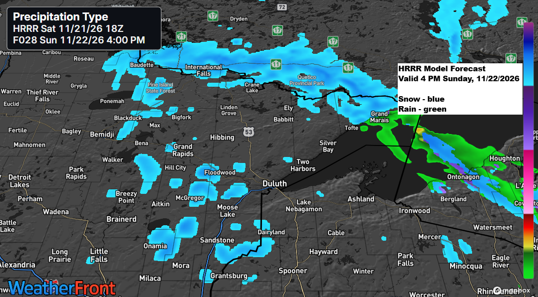
A light dusting of snow is expected across parts of the Northland from Sunday afternoon through Sunday evening as a vigorous vorticity maximum moves east-southeast across the region.
Northern Minnesota, especially the Arrowhead region, is forecasted to receive approximately 0.5 to 1 inch of snow by Sunday evening, with localized areas potentially accumulating up to 2 inches.

Parts of northern Wisconsin are likely to see snow showers from Sunday night into Monday morning, with accumulations ranging from a light dusting to around 2 inches.

The big question is whether Duluth will finally record its first 0.1-inch snowfall of the season on Sunday. If it doesn’t, the wait will continue, inching closer to the latest recorded date for the first 0.1-inch snowfall, which is November 26, set in 2004.
EPS snowfall probabilities show a 51% chance of at least 0.1 inch of snow accumulation in Duluth through 6 AM Monday.

Note that any snow showers in Duluth are likely to occur later on Sunday afternoon or Sunday evening.
HRRR model radar forecast valid from 7 AM Sunday through midnight Monday.
Snow in blue, rain in green.
…Temperatures…
A cooler pattern settles in Sunday, with afternoon temperatures ranging from the 30s to lower 40s across the Northland, a significant change from the unseasonably mild temperatures seen Friday and Saturday morning.

While some colder air arrives this weekend, the coldest temperatures are expected on Monday, with highs likely staying in the 20s across much of the Northland. That’s below normal for late November, as average highs this time of year are generally in the low to mid-30s. It will be a rare taste of winter after a November that has been remarkably and, in some cases, record warm so far.

…Rain tonight…
Tonight, rain extends from southern Minnesota through western, central, and northern Wisconsin into western Upper Michigan. This precipitation will persist for much of the night, tapering off from west to east by mid-morning Sunday.
MRMS radar loop through 5:20 PM CT on Saturday, November 21, 2026.
Rainfall amounts tonight are expected to range from a half inch to over an inch in a southwest-to-northeast band stretching from southeast Minnesota into the western half of upper Michigan.
No rain is expected in Duluth tonight, although parts of northwest Wisconsin may receive between 0.05 and 0.25 inches of rain.

A trough is moving eastward from the Rockies tonight, accompanied by energy on its southern flank lifting east-northeast. Meanwhile, area of energy over southern Saskatchewan will descend southeast through Sunday. Had these systems phased, they could have produced a significant storm across the Upper Midwest tonight and Sunday, but that scenario will not occur.

In addition to the trough impacting our area tonight and Sunday, two other major systems are present today—one over the Atlantic and another over the Pacific.
Goes-West water vapor loop from Saturday, November 21, 2026, ending at 5:45 PM CT.
Leave a Reply