5:15 PM Monday, February 10, 2025
Arctic air is moving into the Northland for the rest of the week.
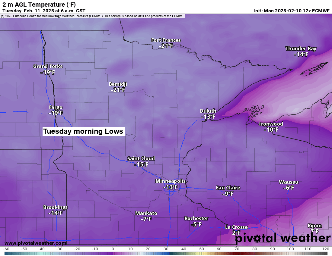
Low temperatures tonight, Tuesday night, and Wednesday night will be in the teens and 20s below zero across the Northland, with some 30s below possible in northern Minnesota.
A cold weather advisory is in effect from late this evening until late Tuesday morning for northeast Minnesota and northwest Wisconsin, with wind chill temperatures between 25 below and 40 below zero.

HRRR model wind chill forecast valid 10 PM this evening to 11 AM Tuesday.

Not a whole lot of warmth out there on Tuesday, as high temperatures will only range from around 5 below to 5 above zero in the Northland, which is around -20 degrees below normal for February 11th.

Lowest temperatures so far this winter
- Hibbing, MN: -35 on January 21st
- International Falls, MN: -34 on January 20th
- Brainerd, MN: -27 on January 21st
- Duluth, MN: -27 on January 21st
- Ashland, WI: -23 on January 21st
Updated seasonal snowfall totals for the 2024-2025 snow season across the region.
-Sault Ste. Marie, Michigan has received almost 160 inches of snow this winter, which is about 73 inches above normal, making it 185% of the usual snowfall.
-Marquette, Michigan has received about 83 inches of snow this winter, which is 40 inches below normal.
-Less snow to the west, with snowfall totals 6 to over 25 inches below normal.

There’s one chance to get some snow in parts of the Northland this week, and that comes Friday to early Saturday. However, this doesn’t look like a major snow event for our area, as the main piece of energy is expected to stay well south of our area as it moves east-northeast out of the southern Rockies later this week.

Snow accumulations from Friday to early Saturday may reach about an inch in many areas of northwest Wisconsin and possibly in parts of northeast and east central Minnesota, including Duluth.
Shown below is the probability of >1 inch snowfall according to the EPS (euro ensemble model)

I shared this forecast back on February 4th on my Facebook page, showing potential snow amounts through February 19th according to the Euro model. It definitely showed the potential for some impressive snow totals across the area.

However, as new data rolled in and the computer models got a better handle on the upcoming pattern, those impressive snow totals have all but vanished from the latest Euro model forecast through February 19th.
The arctic air pushing back towards the south will help force the storm track and winter storm threats south of our area as well.

Several winter storms are expected this week from parts of the Midwest into parts of the mid-Atlantic and northeast U.S.
These storms will follow a notable temperature difference, with cold arctic air to the north and warmer air to the south. The yellow area on the map is likely to experience a few winter storm systems through this weekend.

These storms will have good access to cold Arctic air thanks to one branch of the jet stream coming out of Canada, while warmer air and moisture head northeast associated with the southern branch of the jet stream.

Various winter weather alerts are in effect through midweek.

Here’s the snowfall forecast until Thursday morning from the NWS Blend of Models.
Purple areas=6″ or more of snow

Thanks for reading!
Leave a Reply