6:35 PM Friday, May 16, 2025
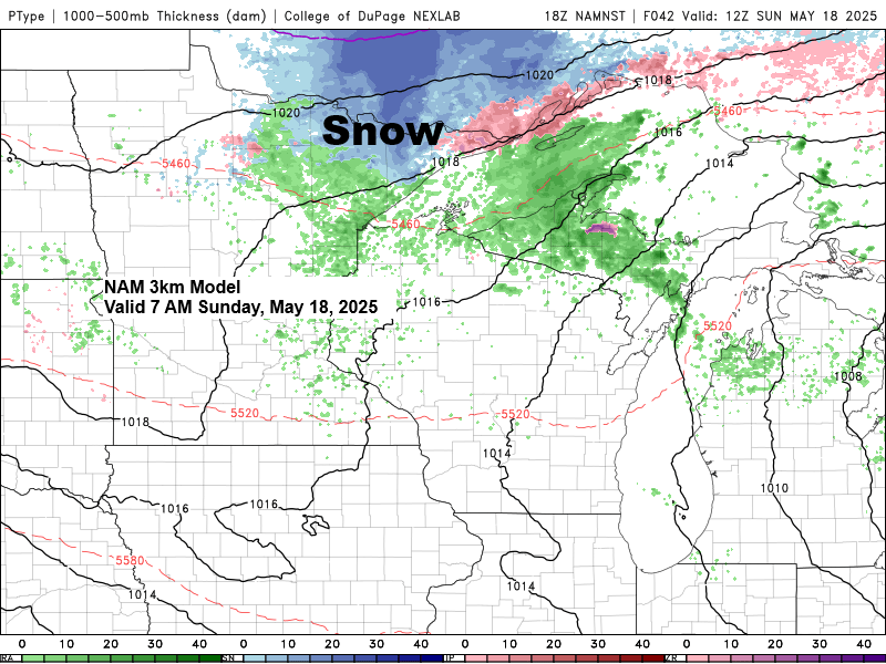
The heat experienced in the Northland last weekend through the middle of the week will contrast significantly with the weather this weekend, as a much cooler pattern sets in. In fact, temperatures may drop low enough for a few hours early Sunday morning to allow for a light snowfall or a mix of rain and snow in parts of northern Minnesota.
Highs in the Northland this weekend will be in the 40s and 50s, about 15 degrees below normal for mid-May. Low temperatures in the 30s are expected Saturday and Sunday nights, with some of the typical colder areas possibly dipping into the 20s.
Rainfall amounts in the Northland on Thursday varied widely which is typical in thunderstorm patterns where some areas get a lot of rain, and others not so much.
A total of 1.78 inches of rain was recorded at International Falls on Thursday, setting a new record for May 15th. The previous record for the wettest May 15th was 1.58 inches of precipitation, set in 1998.
In comparison, Duluth Airport reported only 0.09 inches of rainfall on Thursday and a mere 0.01 inches today (Friday).
Here are some other rainfall totals from Thursday and today.
Brainerd, MN
Friday (thru 4 PM) 0.12″
Thursday’s total: 0.41″
Hibbing, MN
Friday (thru 4 PM) 0.12″
Thursday’s total: 0.28″
Ashland, WI
Friday (thru 4 PM) 0.00″
Thursday’s total: 0.11″
Areas of light rain will linger in parts of the Northland tonight, Saturday, and Sunday, but the key word here is light, and this shouldn’t be a widespread rain event, with a lot of dry hours sprinkled in throughout the weekend.
NAM-Nest simulated radar forecast through 7 PM Sunday.

A lot of severe weather today further to the south.
Red/pink polygons=Tornado Warning
Yellow polygons=Severe Thunderstorm Warning
Radar loop ending 5:44 PM CT Friday, May 16, 2025.
A strong spring storm is moving east across central Minnesota this afternoon, causing severe weather to the south and showers in the Northland.
Goes-16 enhanced water vapor loop ending 5:36 PM CT Friday, May 16, 2025.

The surface low over central Minnesota this afternoon was stronger earlier, dropping to about 980mb in eastern North Dakota, making it a powerful low for May.

I have been monitoring another system for next week, but recent trends in computer models indicate that this system will likely pass well south of the Northland due to a new upper-level ridge establishing itself across the Upper Great Lakes region. As a result, the Northland is expected to remain mostly dry for much of next week, with any rainfall confined to southern Minnesota and further south.

Thanks for reading!
Leave a Reply