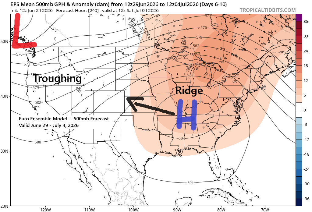
Heading into next week, computer models continue to show signs of a pattern shift, with an upper-level ridge developing across the Midwest and South and troughing out West. This setup will push much warmer air northward into the Upper Midwest, with 500mb heights likely topping 582 decameters and possibly exceeding 588 decameters depending on where the ridge positions itself. However, the ridge is expected to shift west-northwest as we near the 4th of July holiday weekend.
How warm it gets in the Northland next week is still up in the air, with factors like cloud cover, timing of showers and storms, how far north the ridge sets up, and wind direction all playing a role. Still, we’re likely in for several days in the 80s, with muggy dew points in the 60s and 70s at times. Closer to Lake Superior, within about 15 miles, it’ll be much cooler at times depending on the wind direction.
Here’s what the Euro model is forecasting for next Monday, June 29th.
Temperatures soaring into the 90s across much of central and southern Minnesota and western Wisconsin, with 70s and 80s farther north, and cooler conditions near Lake Superior.

Dew points possibly in the 70s across much of the upper Midwest next Monday.

There could be a highly unstable airmass with CAPE values exceeding 3000 J/kg next Monday.
A cold front moving in from the west could trigger one or more rounds of strong to severe thunderstorms in the Northland early next week, depending on how other conditions come together.

Rainfall totals over the 24-hour period from June 23 to 24, 2026, recorded as of 5 PM.
Note: In Payne, MN, 2.25 inches of rain fell in just 45 minutes today.
- Trego Lake, WI: 0.98″
- Spooner, WI: 0.94″
- Winton, MN: 0.89″
- Siren, WI: 0.69″
- Floodwood, MN: 0.56″
- Northome, MN: 0.55″
- Danbury, WI: 0.40″
- Winter, WI: 0.37″
- Solon Springs, WI: 0.34″
- Pleasant Valley, MN: 0.32″
- Pine River, MN: 0.31″
- Willow River, MN: 0.28″
- Minong, WI: 0.27″
- Ely, MN: 0.26″
- Hayward, WI: 0.25″
- Littlefork, MN: 0.22″
- Wright, MN: 0.19″
- Eveleth, MN: 0.16″
- Hog Creek, MN: 0.15″
- Hibbing, MN: 0.15″
- Cass Lake, MN: 0.14″
- Brainerd, MN: 0.13″
- Hill City, MN: 0.13″
- Isabella, MN: 0.12″
- McGregor, MN: 0.11″
- Esko, MN: 0.10″
- Hinckley, MN: 0.09″
- Walker, MN: 0.09″
- Saginaw, MN: 0.09″
- Superior Airport: 0.07″
- Clam Lake, WI: 0.06″
- International Falls, MN: 0.04″
- Duluth Airport: 0.04″
- Poplar, WI: 0.03″
- Glidden, WI: 0.03″
The low-pressure system that’s brought rain and scattered thunderstorms to parts of the Northland over the past day will continue drifting southeast tonight, though showers and a few storms will stick around in some areas until around midnight.
Isolated showers may return on Thursday, but the rain coverage won’t be nearly as widespread as it was on Wednesday.
Radar loop ends 6:04 PM Wednesday, June 24, 2026.
Leave a Reply