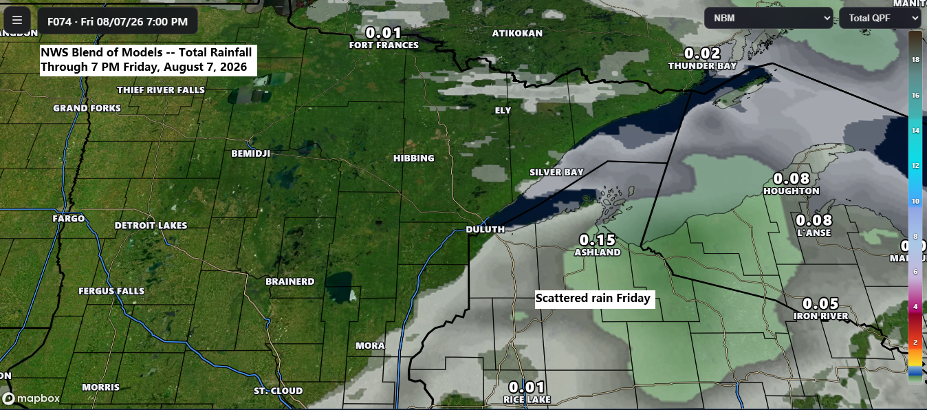
It looks like we’re in for the nicest stretch of weather this summer in northeast Minnesota and northwest Wisconsin, with dry days ahead, low humidity, and pleasantly warm afternoons.
The only real chance for rain through early next week is on Friday, mainly in northern Wisconsin, where a few scattered showers might pop up as a cold front moves through the area.
…Long term dry pattern…
As of August 3rd, 2026, Duluth, Minnesota has seen slightly less rain than usual, down 0.56 inches. The real story, though, is the past couple of years, with big shortfalls of 10.83 inches in 2025 and 3.18 inches in 2024. All told, Duluth is still 14.57 inches below average since 2024.
Here’s a look at how precipitation levels varied from the average between January 1, 2024, and August 3, 2026.
Since 2024, much of the Northland has been running well below average, except for the North Shore and Arrowhead—especially around Grand Marais—which have been well above average, along with a smaller stretch between Hibbing and Ely that’s also been above average.

Cooler temperatures settled into the Northland today following Monday’s cold front, while the southern U.S. continues to bake under the heat with several upper-level highs dominating the region.
The weather pattern will hold steady through the weekend, with the upper Midwest under a northwest to west-northwest flow aloft between a stubborn upper low over central Canada and a ridge in the south. This setup keeps the hottest temperatures to our south, while the Northland enjoys comfortable highs in the 70s and 80s, with Thursday shaping up to be one of the warmest days of the stretch.

Plenty of cumulus and stratocumulus clouds linger over the Northland today in the wake of Monday’s system, but sunnier skies are expected in the days ahead.
Goes-19 visible satellite loop ending 5 PM CT Tuesday, August 4, 2026.

If you’d like to support this weather blog, you can donate below.
Make a one-time donation
Make a monthly donation
Make a yearly donation
Choose an amount
Or enter a custom amount
Your contribution is appreciated.
Your contribution is appreciated.
Your contribution is appreciated.
…Summer temperature trends…
By August 3rd, summer 2026 in Duluth has been 2.4 degrees warmer than last summer.
The average temperature in Duluth from June 1, 2026, to August 3, 2026, was 66.0 degrees.
Temperature anomaly for summer 2026 through August 3rd.

From June 1 to August 3, 2025, Duluth had an average temperature of 63.6 degrees.
Temperature anomaly for summer 2025 up to August 3rd.

…Summer precipitation trends…
This summer has been drier across much of the Northland compared to last year, though Duluth has actually received over 2 inches more rain than last summer as of August 3rd.
Percentage of normal rainfall for summer 2026 up to August 3rd.
Dry regions are shown in yellow, while wet regions are marked in green.

Percentage of normal rainfall for summer 2025 up to August 3rd.
Green marks the wet areas, while yellow highlights the dry ones.

Leave a Reply