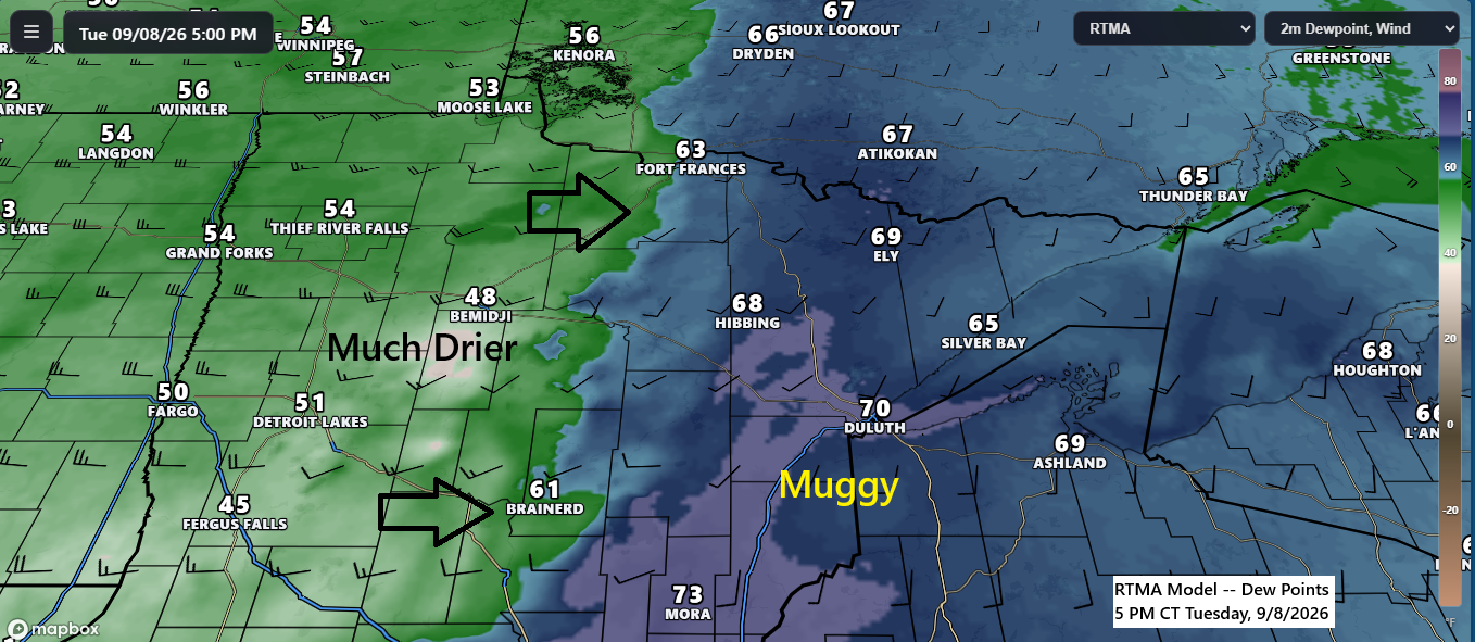
A cold front is moving east across Minnesota this afternoon and is expected to clear the Northland by late tonight. Behind the front, a much drier airmass will return on Wednesday, with dew points dropping from the 60s and low 70s today to the 40s and 50s.
Some instability has developed near the eastward-moving cold front this afternoon, but a lingering cap and cloud cover ahead of the front make it uncertain whether any showers or thunderstorms will form this evening. If anything does develop, northwest Wisconsin and far eastern Minnesota appear to have the highest chance of seeing activity.
Expect gusty west winds across the Northland tonight through Wednesday, with sustained speeds of 15-25 mph and occasional gusts up to 40 mph overnight into Wednesday morning. West gales are anticipated on Lake Superior on Wednesday, with the highest waves forecasted east of the North Shore.
The precipitation data for Duluth, Minnesota has been officially updated to reflect the rainfall recorded early Tuesday morning.
Month to date
Total: 2.00″
Departure: +1.05″
Note: Percent of normal precipitation from September 1–8, 2026, reached approximately 210% of the typical amount.
Year to date
Total: 21.56″
Departure: -0.75″
A fast-moving upper trough from today’s system will cross the Northland on Wednesday. Moisture will be limited, but the trough could still spark a few brief showers, mainly before noon.

Here’s a model radar projection for 7 AM Wednesday: a few light showers are expected over west-central Minnesota and eastern North Dakota, which may move east across the Northland during the morning. Any rainfall is likely to be brief and minimal.

Check out the system over Manitoba today—it’s truly impressive! Also of interest is the strong circulation over Montana, which will move quickly east across the Northland Wednesday morning, though it is expected to bring little precipitation.
Goes-19 water vapor loop from Tuesday, September 8, 2026, loop time ends 5:50 PM CT.

Friday afternoon and evening in the Northland will likely bring showers and scattered thunderstorms as the next organized system moves across the upper Midwest. The system is expected to pass quickly, with dry weather returning on Saturday.

Forecasted rainfall for Friday in northeast Minnesota and northwest Wisconsin is expected to range from 0.5 to 1 inch, with lower totals anticipated in the far western and eastern portions of the region. As this system remains several days away, these estimates are subject to adjustment.

Rain is likely to return to the Northland on Sunday and Monday, driven by a potentially strong system moving northeast from the northern Rockies.

Leave a Reply