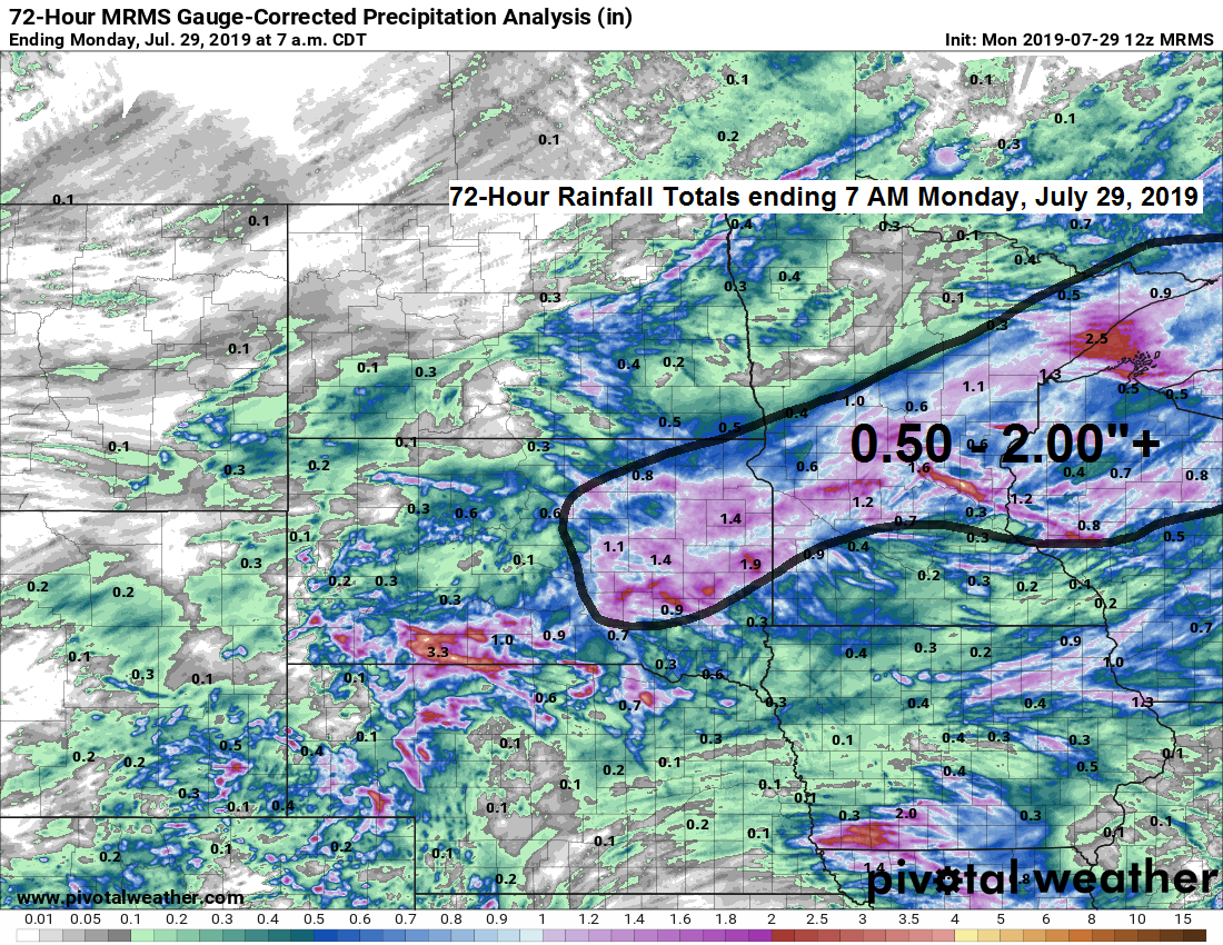
A rather large swath with half inch to 2 inch plus rainfall totals since last Friday, July 26, the bulk of this rain fell Friday afternoon/evening, and again on Sunday.
Source: https://www.pivotalweather.com/

Rainfall reports from Sunday, July 28, 2019
Source: https://www.weather.gov/dlh/
- Duluth Airport: 1.53 inch
- Wolfridge ELC: 1.36 inch
- Morgan Park, MN: 1.32 inch
- Floodwood, MN: 1.25 inch
- 4 E Island Lake, MN: 1.19 inch
- 3 E Wright, MN: 1.17 inch
- Brainerd, MN: 1.16 inch
- Butternut, WI: 0.72 inch
- Hibbing, MN: 0.60 inch
- Ashland, WI: 0.56 inch
- Grand Marais, MN: 0.55 inch
- Hayward, WI: 0.49 inch
- 4 W Clam Lake, WI: 0.47 inch
- Hurley, WI: 0.45 inch
- Winter, WI: 0.40 inch
- Embarrass, MN: 0.30 inch
- Babbitt, MN: 0.22 inch
- Northome, MN: 0.06 inch
- 12 N Grand Rapids, MN: 0.05 inch
Cooler temperatures across the area today, in fact today’s highs were the coolest we’ve seen around here since June 21 at Duluth (71 F) and at International Falls you have to go back to June 17 (63 F)

Certainly seeing some signs in long range model data for a cooler weather pattern locking in by next week. Blue and green colors on the map below represent below normal temperatures while orange and red colors represent above normal temperatures. Temperature anomaly forecast shown below valid from August 5 through 13 per 12 Euro Ensemble model.
Source: https://weathermodels.com

Low temperature forecast for Tuesday morning, July 30.
Yes it will be a cool late July night, but probably not record cold — See record lows list below for July 30.
- Ashland: 36 F set in 1918
- International Falls: 38 F set in 1898
- Brainerd: 40 F set in 1978
- Hibbing: 41 F set in 1964, tied in 1971, 1992 and 2004
- Duluth: 42 F set in 1971, tied in 1992
Source: https://graphical.weather.gov

High temperature forecast for Tuesday, July 30.

…Weather Summary…
A nice stretch of weather is underway.
Strong low pressure has moved to near Hudson Bay Canada today with high pressure heading into the northern Plains. Gusty northwest winds were occurring in the Northland today due to a tight pressure gradient between the low and high. Cold air advection in wake of Sunday’s low has dropped 850mb temperatures to +8 to +10C today.
Fairly tranquil weather conditions through midweek as high pressure moves slowly E-SE out of the northern Plains. About the only weather issue will be some areas of fog late at night into the early morning hours, otherwise we’re looking at mostly clear skies through Wednesday.
Lows tonight and Tuesday night in the 40s and 50s. Highs Tuesday ranging from around 70 to the middle 70s with highs Wednesday in the 70s to around 80.
Southerly flow develops later this week as high pressure scoots off to the east. Will see an increase in dew points (humidity) Thursday and Friday so it will be turning muggier later this week. Also looks warm with highs Thursday and Friday mainly in the 80s.
Looks like we could be dealing with some scattered showers or thunderstorms in parts of the Northland late this week into the weekend, but doesn’t look like complete washouts at this time.
Leave a Reply