39 days so far this summer (since June 1) with a high temperature of at least 80 degrees at Duluth, Minnesota. Average number of 80 degree days in Duluth from June 1 to August 31 is 23 days.
Note: So far the summer of 2019 in Duluth has been warmer and drier compared to last summer through August 10 – See stats below.
June 1 through August 10, 2019
- Average temperature: 67.0 degrees
- Departure: +3.6 degrees above normal
- Precipitation: 7.80″
- Departure: -1.42″ below normal
June 1 through August 10, 2018
- Average temperature: 65.8 degrees
- Departure: +2.4 degrees above normal
- Precipitation: 9.55″
- Departure: +0.33″ above normal
Temperature and Precipitation report for Duluth, Minn
August 4-10, 2019
High Temperatures/Departure from Normal
- 8/4: 86F/+10 degrees above normal
- 8/5: 82F/+6 degrees above normal
- 8/6: 84F/+8 degrees above normal
- 8/7: 79F/+3 degrees above normal
- 8/8: 75F/-1 degree below normal
- 8/9: 78F/+2 degrees above normal
- 8/10: 82F/+6 degrees above normal
Low Temperatures/Departure from Normal
- 8/4: 59F/+3 degrees above normal
- 8/5: 63F/+7 degrees above normal
- 8/6: 57F/+1 degree above normal
- 8/7: 59F/+3 degrees above normal
- 8/8: 54F/-2 degrees below normal
- 8/9: 56F/+1 degree above normal
- 8/10: 54F/-1 degree below normal
Note: Average temperature for the week of Aug 4: 69.1 degrees (+3.5 degrees above normal) Source: https://www.dnr.state.mn.us
- Total Precipitation: 0.76″
- Normal: 0.81″
- Departure: -0.05″ below normal
State Average for Minnesota for the week of Aug. 4, 2019
- Temperature: 69.6 degrees
- Departure: +0.5 degrees above normal
- Precipitation: 0.56″
- Departure: -0.27″ below normal
Temperature departure map for the week of Aug. 4, 2019. Source: https://hprcc.unl.edu

Precipitation departure map for the week of Aug. 4, 2019.

Temperature anomaly forecast valid from August 12 through 16, 2019 — Cooler temperatures moving in the next few days. Blue and green colors on the map below indicate below normal temperatures. Normal highs this week in the Northland are generally in the mid 70s, normal lows are in the low to mid 50s. Coolest days this week look to be Tuesday and Wednesday with highs ranging from the lower 60s to lower 70s.
Note: Looks like we could warm up and turn a little more humid late this week or next weekend.
Source: 12z European ensemble model; https://weathermodels.com

Low temperature forecast for Monday morning, Aug. 12. Source: https://graphical.weather.gov

High temperature forecast for Monday, Aug. 12.

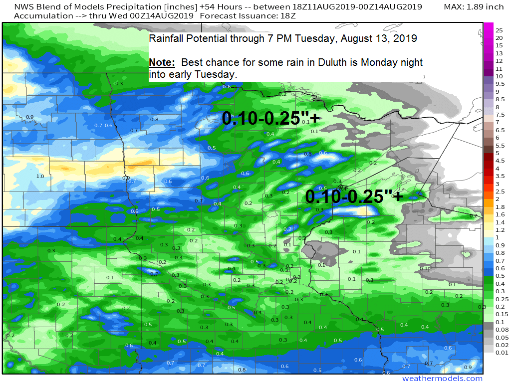
Looks like most of the Northland will get some rain Monday into Tuesday with the best chance coming late Monday afternoon through early Tuesday morning. Note: Far northeast Minnesota including Grand Marais, Hovland and Grand Portage look to get the least amount of rain with this system (totals of one tenth inch or less) The rest of the Northland look to get between a tenth and quarter inch of rain with higher amounts mixed in which could exceed an inch in some locations.

Water vapor satellite image; analysis from Sunday afternoon, August 11, 2019.
Source: https://weather.cod.edu

…Weather Summary…
Upper level ridge (hot weather) over the southern Plains will remain in that general area through the week, although it could retrograde a bit. West to northwest flow aloft will continue in the Northland well north of that ridge. The main feature to watch for rain prospects this week is the system over the northern Rockies today, this system moves east/southeast through Tuesday, but could also weaken a bit as it does so, if it weakens enough, then the amount of rain we get around here won’t be very much.
Spotty showers affecting a small part of eastern Minnesota and far northwest Wisconsin this afternoon due in part to a lake breeze boundary will dissipate this evening, otherwise partly to mostly cloudy skies for tonight with patchy fog. Lows in the 50s to around 60, except for a few 40s in the typical cool spots. North or east winds around 10 mph.
Partly to mostly cloudy skies for Monday, not as warm as it has been lately, but not that cool either. Highs ranging from the upper 60s to middle 70s with easterly winds 10 to 15 mph. Some showers could begin to affect parts of north-central Minnesota during the day with the rest of the area possibly getting some rain Monday night. There will be a bit of elevated instability which sneaks into parts of the area Monday night, and this could be enough to ignite a thunderstorm, but not expecting much thunder with this system.
Scattered showers could linger into Tuesday due to a cold front which back doors its way through the Northland, this will kick up the easterly wind on Tuesday with gusts 15 to 25 mph near Lake Superior.
Dry weather returns Wednesday. Highs Tuesday and Wednesday ranging from the lower 60s to lower 70s.
Overall the next several days will be cooler with no more 80s expected in Duluth through Friday (16th) Best chance for rain this week looks to be Monday night-Tuesday, with scattered rains possible later in the week/next weekend.
Leave a Reply