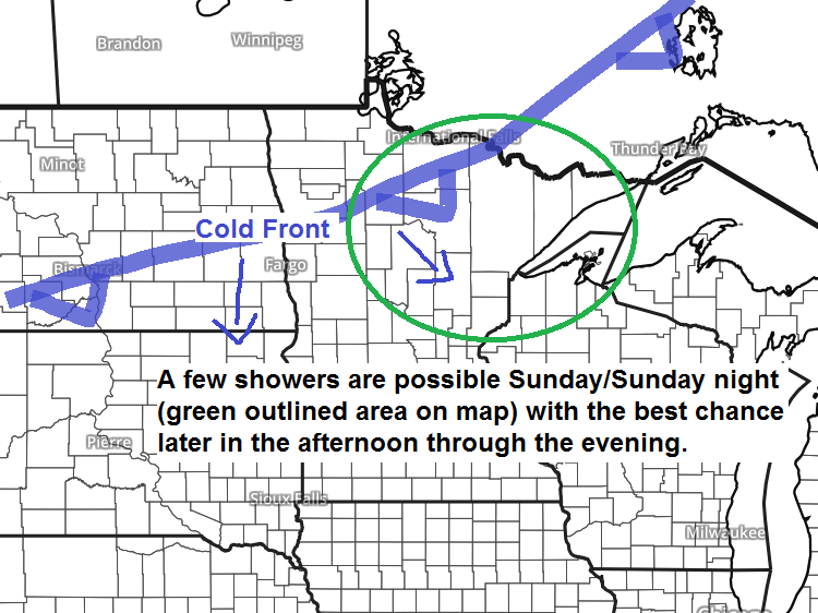
A cold front will move southeast across the Northland Sunday afternoon into Sunday night with a chance of a few showers as that front moves through.

A risk of strong to severe thunderstorms returns to the Northland Monday night.

An elevated mixed layer will be in place Monday over the Western High Plains with hot and dry conditions. Strong southerly flow ahead of this EML will help push higher amounts of (CAPE) instability and moisture E-NE into the upper Midwest Monday night which could lead to the development of strong to severe thunderstorms in parts of the Northland.
Source: 18z NAM model; https://weather.cod.edu

The month of September kicks off on Sunday, here are the climate numbers for Duluth, Minnesota.
Average monthly temperature: 55.6 degrees
- Warmest 62.6 degrees set in Sept 1897
- Coldest 47.8 degrees set in Sept 1974
Precipitation: 4.11″
- Wettest: 11.52″ set in Sept 1881
- Driest: 0.19″ set in Sept 1952
Snowfall: 0.1″
- Snowiest: 2.4″ set in Sept 1991
Normal temps
- 1st: High 71F; Low 52F
- 30th: High 59F; Low 40F
Average number of 70 degree days in September: 9 (most was 20 days set in 2009)
Average number of 80 degree days in September: 2 (most was 10 days set in 1908)
Average number of days with a low temp of 32 degrees or colder: 1 (most was 7 days set in 1974)
Notes
Average last date for 80 degree temperature in Duluth is September 11 (1874-2018 climate period) Latest last 80 was October 21, set in 1901.
The list below shows the date of the last 80 degree temperature in Duluth from 2010 through 2018.
- 2010: Aug 31
- 2011: Oct 7
- 2012: Sept 11
- 2013: Sept 7
- 2014: Sept 28
- 2015: Oct 11
- 2016: Sept 5
- 2017: Sept 23
- 2018: Sept 16
Average date for first 32 degree low temperature in Duluth is September 30; latest was November 6 set in 1900.
The list below shows the date of the first 32 degree low temperature in Duluth from 2010 through 2018.
- 2010: Sept 26
- 2011: Sept 15
- 2012: Oct 6
- 2013: Oct 19
- 2014: Oct 6
- 2015: Oct 7
- 2016: Oct 9
- 2017: Oct 9
- 2018: Sept 29
*We have quite a streak going! 8 Septembers in a row have been warmer than average in Duluth. Will September 2019 break this trend? Or will it follow the trend of the last 8 Septembers? We shall see.
*The last colder than average September in Duluth occurred in 2010.
*Since 2000, we’ve had 4 colder than average Septembers and 15 which have been warmer than average.
Dorian is a major hurricane as of Saturday afternoon with winds of 150 mph, movement is off to the west at 8 mph.
Goes-16 infrared satellite loop of Dorian from Saturday afternoon, August 31, 2019. Source: https://www.tropicaltidbits.com

…5 PM Advisory on Hurricane Dorian…
Source: https://www.nhc.noaa.gov
- Location: About 170 miles east of Great Abaco Island; about 355 miles east of West Palm Beach Florida
- Maximum Sustained Winds: 150 mph
- Present Movement: West at 8 mph
- Minimum Central Pressure: 945mb/27.91″
There’s been some major changes in model guidance with the track of Dorian over the last 24-36 hours. The center of Dorian is now forecast to pass east of Florida, and the center of Dorian could very well remain offshore as it moves up the east coast during the middle to end of next week. Stay tuned.

Low temperature forecast for Sunday morning, September 1. Source: https://graphical.weather.gov

High temperature forecast for Sunday, September 1

…Weather Summary…
A very pleasant end to August with scattered clouds, light winds and high temps which were close to normal, ranging from the mid 60s to lower 70s.
Southerly winds on Sunday will draw a little more moisture into the area with dew points climbing into the mid 50s to around 60 degrees. Some lift associated with a southeastward moving cold front combined with the increase in low level moisture will cause a few showers in the Northland on Sunday into Sunday night. Note: Not expecting widespread heavy rain Sunday, only a few showers with many dry hours still expected. Highs Sunday should be quite similar to what we saw on Saturday with highs in the mid 60s to low 70s.
Looks dry during the day Monday, then will see shower and thunderstorm chances ramp up Monday night into Tuesday morning as a deepening low along with a warm front and cold front move across the upper Midwest.
Forecast for Duluth and Superior
.Tonight… Partly to mostly cloudy. Low 50 to 55. Wind south to southeast around 10 mph.
.Sunday… A few showers possible otherwise partly to mostly cloudy. High 68 to 73. Wind southwest 10 to 15 mph.
.Labor Day… Partly to mostly cloudy. High 65 to 70. Wind east 10 to 20 mph.
Normal temperatures for September 1
- High 71
- Low 52
- Sunrise Sunday 6:28 AM CDT
- Sunset Sunday 7:48 PM CDT
Note: By the end of September the sunrise is at 7:05 AM; sunset at 6:50 PM.
Thanks for reading!
Leave a Reply