Strong to severe thunderstorms remain a possibility across the Northland from Monday evening through early Tuesday morning. Hazards include large hail, damaging wind gusts, lightning and heavy rain. Stay Weather Aware Monday night!

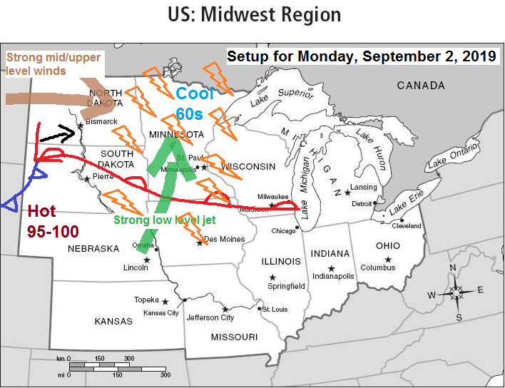
Low pressure is forecast to deepen while moving E/NE out of the western Dakotas from Monday into Tuesday, the low should pass over Lake Superior on Tuesday.
A warm front (red line of map) attached to the low will lift NE while a cold front (blue line on map) pushes east. Both of those fronts are expected to move quickly through the Northland Monday night into Tuesday morning.
A strong southerly low level jet increasing to 35-55 knots develops ahead of this system on Monday which will advect a warmer and more humid airmass north into the upper Midwest.
A pool of strong instability associated with an elevated mixed layer (EML) will be over the Northern Plains on Monday, and some of this instability will advect E-NE into the Northland Monday night once the low level jet gets going.
Showers and thunderstorms are expected to develop across the Northland Monday afternoon but more so Monday night as lift increases with the approach of the low, warm front and cold front.

Radar forecast valid from 7 PM Sunday to 7 AM Tuesday per 18z NAM-WRF model.
Spotty showers with the cold front tonight, followed by more widespread showers and thunderstorms Monday afternoon into Monday night as a warm front, cold front and area of low pressure move across the area. Rain exits to the east Tuesday morning.
Source: https://weathermodels.com

Source: https://www.spc.noaa.gov
Weather nerds (including me) love this kind of stuff. The battle of the seasons between fall and summer. Fall is attempting to get rid of summer, while summer is putting up a good fight to linger a while longer. Will likely see this battle continue a few more weeks before fall is here for good, well at least until winter shows up. Enjoy!

Low temperature forecast for Monday morning, September 2. Source: https://graphical.weather.gov

High temperature forecast for Monday, September 2

***Hurricane Dorian Update***
Source: Twitter, National Hurricane Center, National Weather Service
At 12:40 PM EDT, Dorian makes landfall on Elbow Cay in the Abacos as a category 5 storm with winds of 185 mph. Only 4 storms on record since 1851 in the Atlantic had estimated winds of 185 mph or higher. http://@MichaelRLowry
- Allen (1990) – 190 mph
- Wilma (2005) – 185 mph
- Gilbert (1988) – 185 mph
- 1935 Labor Day – 185 mph
Preliminary — Dorian’s pressure of 910 mb ties for 5th all time lowest at landfall in the Atlantic basin.
At 185 mph, Dorian is tied for 2nd strongest in the Atlantic basin. Only Allen (1980) was stronger at 190 mph.
The 185 mph landfall is tied with the Labor Day hurricane (1935) for strongest wind speed at landfall in the Atlantic basin.
5 PM EDT update on Dorian; Source https://www.nhc.noaa.gov
- Location: About 95 miles east of Freeport Grand Bahama Island; about 175 miles east of West Palm Beach Florida.
- Maximum Sustained Winds: 185 mph
- Present Movement: West at 5 mph
- Minimum Central Pressure: 910 mb; 26.88″
Source: https://www.tropicaltidbits.com
Dorian is a monster! Incredibly dangerous and slow moving storm.

Latest track of Dorian per NHC. This storm is currently crawling toward the west and is eventually forecast to turn more northwest, and then north-northeast later this week. It’s going to be a long and potentially dangerous week from the east coast of Florida to the Carolinas.

Source: https://www.spc.noaa.gov

Temperature and Precipitation report for Duluth, Minnesota for August 25 through August 31, 2019
High Temperatures/Departure from Normal
- 8/25: 74F/+1 degree above normal
- 8/26: 66F/-7 degrees below normal
- 8/27: 70F/-2 degrees below normal
- 8/28: 70F/-2 degrees below normal
- 8/29: 70F/-2 degrees below normal
- 8/30: 72F/+1 degree above normal
- 8/31: 74F/+3 degrees above normal
Low Temperatures/Departure from Normal
- 8/25: 54F/+1 degree above normal
- 8/26: 60F/+7 degrees above normal
- 8/27: 54F/+1 degree above normal
- 8/28: 53F/Normal
- 8/29: 50F/-2 degrees below normal
- 8/30: 47F/-5 degrees below normal
- 8/31: 46F/-6 degrees below normal
Average temperature for the week of August 25: 61.4 degrees; -0.8 degrees below normal.
- Total Precipitation: 0.95″
- Normal: 0.87″
- Departure: +0.08″ above normal
State Average for Minnesota for the week of August 25, 2019; source: https://www.dnr.state.mn.us
- Temperature: 62.1 degrees
- Departure: -3.8 degrees below normal
- Precipitation: 0.75″
- Departure: -0.08″ below normal
Temperature departure map for the week of August 25, 2019.
Widespread below normal temperatures in the Northland last week. Note: Blue and purple colors on map indicate average temps some 4 to nearly 8 degrees below normal. Source: https://hprcc.unl.edu

Precipitation departure map for the week of August 25, 2019.
Near to above normal precip totals in most of the Northland last week, but the yellow areas on map indicate near to below normal precip totals.

…Weather Summary…
Keeping an eye on the beast which is Dorian, and also on our local weather which includes rain and thunderstorm chances along with a few frost threats this week.
A cold front is entering northern Minnesota this Sunday afternoon. We’ve seen widespread clouds ahead of this front along with a few spotty showers and sprinkles in the area today. The clouds really did a number on the high temps today which were only in the 60s (below normal for the 1st of September)
Cold front will get a nice push south tonight as high pressure builds in from the northwest. The cold front is forecast to be over northern Iowa by dawn. A few showers will be possible tonight as the cold front moves through but this shouldn’t be a big deal. Mostly cloudy skies tonight but some clearing could work its way south later in the night. Lows will be in the 40s and 50s but a few 30s can’t be ruled out in the typical cool spots in northern Minnesota. Winds tonight shifting from southwest to north.
Labor Day will find tonight’s cold front lifting back north as a warm front while low pressure and cold front work their way east out of the Dakotas. The atmosphere will respond by producing showers and thunderstorms, although I think most of us will remain dry for most of Labor Day before rain chances increase from west to east later in the afternoon. Highs Monday will range from the 50s along the North Shore with 60s to lower 70s elsewhere. Winds will be out of the east 5 to 15 mph.
Low pressure with its warm front and cold front exit to the east Tuesday with gusty winds and cold air advection moving in behind this system. West winds gusting 20 to 30 mph with 850mb temperatures of +10 to +15C at 7 AM Tuesday, dropping to around zero to +5C by 7 PM Tuesday. This should set the stage for a frost threat early Wednesday morning (especially away from Lake Superior)
Will see another cold front move through the area later this week with possible showers sometime in the Thursday-Friday time frame, following this frontal passage will be an even cooler shot of air for next weekend (September 7-8) with another chance for a frost.
Forecast for Duluth and Superior
.Tonight… Mostly cloudy with isolated showers possible before Midnight. Partly to mostly cloudy overnight. Low 50 to 55. Wind southwest 5 to 15 mph becoming north late.
.Labor Day… Partly to mostly cloudy. A few showers possible later in the day. High 61 to 66. Wind east 10 to 20 mph.
.Monday night… Occasional showers and thunderstorms. Lows in the 50s. Breezy. Wind east 15 to 25 mph.
.Tuesday… Breezy. Showers early followed by mostly cloudy skies. High 65 to 70. Wind becoming west 15 to 30 mph.
Normal temperatures for September 2
- High 70
- Low 51
- Sunrise Monday 6:29 AM CDT
- Sunset Monday 7:47 PM CDT
Thanks for reading!
Leave a Reply