It’s been a wet September in Duluth but not wet enough to break into the top 5 wettest Septembers on record, at least not yet.
Note: The list below shows the top 5 wettest Septembers on record in Duluth and the year they were set. Through September 23, Duluth has picked up 4.42″ of rain, will need an additional 2.39″ of rain the rest of the month in order to get into the top 5.
- 11.52″ set in 1881
- 9.38″ set in 1991
- 8.68″ set in 1876
- 7.72″ set in 1905
- 6.81″ set in 2015
Note: September 2019 is on pace to be the 9th September in a row where the average monthly temperature was above normal in Duluth. Average temperature for September 2019 (thru the 23rd) 61.0 degrees; +4.0 degrees above normal. Even with some cooler weather coming the next few days it seems unlikely it would be enough to knock the average monthly temp below normal. The last time a September had a below average monthly temperature in Duluth was in 2010.
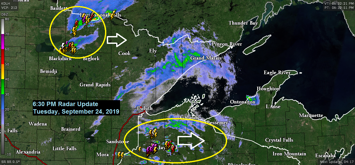
Two areas of thunderstorms late this afternoon, one in far northern Minnesota, the other in northwest Wisconsin, both are moving to the east. These storms this evening will be prolific lightning producers especially in northwest Wisconsin as there is a lot of energy pushing NE out of southern Minnesota early this evening.

Tornado Watch in effect until Midnight from southern Minnesota into west-central Wisconsin.

Quite an active weather pattern in place with strong mid/upper level lows in the northeast U.S. and southwest U.S. while a potent trough heads into the upper Midwest. Also note the streak of moisture moving rapidly E-SE out of Montana into South Dakota today, as this feature moved closer to richer low level moisture and strong instability it helped to kick off severe thunderstorms late this Tuesday afternoon in western Iowa, and soon it will likely trigger severe weather in southern Minnesota and in parts of Wisconsin.
Source: Goes-16 water vapor satellite imagery; https://weather.cod.edu

Source: 21z RAP model; https://weather.cod.edu

Low temperature forecast for Wednesday morning, September 25. Source: https://graphical.weather.gov

High temperature forecast for Wednesday, September 25.

Source: https://www.wpc.ncep.noaa.gov

Looks like a fairly active pattern setting up late this weekend into early next week (~September 29-October 1)
Warm and humid air lifting north into the upper Midwest with much colder temperatures across the northern Rockies. This contrast in temperatures, along with at least one area of low pressure lifting NE out of the Rockies should lead to some more rain in the Northland late this weekend into early next week. Thunderstorms are also possible if enough elevated instability can build north, and right now the computer models show that happening to the point where we could have some severe weather in parts of the Northland sometime between Sunday night and Tuesday. Stay tuned

…Weather Summary…
All eyes are on the severe weather event that is expected this evening from southeast Minnesota into central Wisconsin with the northern portion of the severe threat clipping southeastern portions of northwest Wisconsin this evening, mainly along and east of a line from Shell Lake to Upson.
Starting to see a few showers become a little more organized as of 5 PM from around Sandstone to Solon Springs and this may be the beginnings of the severe weather as this activity moves farther east and taps into better moisture and instability that is in place across northern Wisconsin where dew points are in the lower 60s this afternoon along with CAPE to around 1500 J/kg. There is strong wind shear of around 50 knots in northern Wisconsin which is favorable for storm organization and a severe risk with large hail and damaging wind gusts being the primary hazards this evening.
Another area of scattered showers and thunderstorms will affect northern Minnesota this evening with a risk for hail which could approach severe criteria (1.00 inch in diameter/quarter size)
Otherwise for tonight expect generally mostly cloudy skies with some breaks in the clouds at times. Lows will be in the upper 40s to middle 50s with southwest or west winds 5 to 15 mph.
Breezy on Wednesday with west winds 15 to 30 mph. Will have partly to mostly cloudy skies with a few showers and possibly a thunderstorm thanks to a pocket of cold air aloft which settles into the Northland with 500mb temps of -20 to -25C. Highs Wednesday will range from the middle 50s to middle 60s.
Thursday starts dry, but rain chances increase across the Northland Thursday afternoon or evening with some rain expected into Friday morning before drier weather returns Friday afternoon through Saturday.
Note: There is a risk for patchy frost in parts of the Northland Thursday morning, but there is a greater chance for widespread frost Saturday morning, especially inland from Lake Superior.
Forecast for Duluth and Superior
.Tonight… Mostly cloudy. A few showers possible. Low 50 to 55. Wind variable becoming west to southwest 10 to 20 mph.
.Wednesday… Breezy and cooler. Partly to mostly cloudy with a few showers. High 60 to 65. Wind west 15 to 30 mph.
.Thursday… Increasing cloudiness. Showers possible late. High 61 to 66. Wind southwest 10 to 20 mph.
Normal temperatures for Wednesday
- High 61
- Low 42
- Sunrise Wednesday 6:59 AM CDT
- Sunset Wednesday 7:01 PM CDT
Thanks for reading!
Leave a Reply