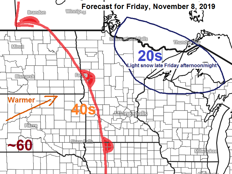
Temperatures Friday afternoon will be close to 60 degrees in southern South Dakota but here in the Northland will have highs ranging from the mid 20s to around the freezing mark with some light snow possible later in the day.

Note: Wednesday’s high temperatures at Ashland (28F) Hibbing (21F) and International Falls (23F) all ranked in the top 5 for lowest maximum temperature on record for November 6.
Source: 12z NAM model 11.7.19; https://weathermodels.com/

18z NAM-WRF model radar forecast valid from Noon Friday to 6 AM Saturday.
Light snow is possible in parts of northern into northeast Minnesota and far northwest Wisconsin from late Friday afternoon into Friday night.

Here’s my snowfall forecast for Friday night.

Low temperature reports of 20F or colder from around the Northland for Thursday morning, November 7, 2019. Source: https://www.weather.gov/dlh/
- Bigfork, MN: 0F
- Northome, MN: 3F
- Cotton, MN: 3F
- Pine River, MN: 5F
- Siren, WI: 5F
- Cass Lake, MN: 5F
- Hibbing, MN: 7F
- Grand Rapids, MN: 7F
- 3 E Wright, MN: 7F
- Hayward, WI: 8F
- Walker, MN: 8F
- 2 E Celina, MN: 8F
- Cook, MN: 9F
- Eveleth, MN: 9F
- Aitkin, MN: 9F
- Moose Lake, MN: 9F
- Solon Springs, WI: 9F
- 4 E Island Lake, MN: 9F
- Grand Marais Airport: 10F
- Longville, MN: 10F
- Hinckley, MN: 10F
- Embarrass, MN: 11F
- Duluth Airport: 12F
- Orr, MN: 12F
- Crane Lake, MN: 12F
- McGregor, MN: 12F
- Superior Airport: 12F
- Cook, MN: 12F
- Wolfridge, MN: 12F
- International Falls, MN: 13F
- Butternut, WI: 13F
- 4 W Clam Lake, WI: 13F
- Ely, MN: 14F
- Brainerd, MN: 15F
- Duluth Harbor: 16F
- Two Harbors, MN: 16F
- Silver Bay, MN: 16F
- Ashland, WI: 17F
- Grand Marais, MN: 19F
Low temperature forecast for Friday morning, November 8. Source: https://graphical.weather.gov/

High temperature forecast for Friday, November 8

Frigid airmass is still on schedule for next week with the coldest days in the Northland next Monday and Tuesday the way it looks now, daytime highs on those days are forecast to be in the teens to around 20 degrees, lows in the single digits below to around 10 above zero. Note: Record cold high temps are possible in the Northland early next week.
Temperature anomaly forecast valid November 10 through November 15, 2019 — Blue, green and purple colors on the loop below indicate below to well below normal temperatures, look how far south this cold airmass makes it next week!
Source: 12z European model 11.7.19; https://weathermodels.com/

…Weather Summary…
Strong area of high pressure averaging 1034mb was over western Iowa late this Thursday afternoon. The Northland remained on the N-NE side of this high today which led to another very cold day with 850mb temperatures down to -16 to -18C today, that’s impressive for early November. Highs today were only in the upper teens to middle 20s.
Partly to mostly cloudy skies are forecast in the Northland tonight with lows in the single digits and teens. Light and variable wind around 10 mph.
Milder airmass pushes into the area on Friday as high pressure centers itself SE of the upper Midwest which gets us into a southerly return flow on the backside of the departing high.
Partly to mostly cloudy skies on Friday with highs ranging from the middle 20s to middle 30s. Winds will be out of the south at 10 to 20 mph.
Light lake effect snow showers are possible Friday along the North Shore of Lake Superior as winds shift to the south but little if any snow accumulation is expected.
A better chance for a light snowfall occurs late Friday afternoon into Friday night as low pressure and a warm front approach from the west. Snowfall amounts should generally be under an inch Friday night in northern Minnesota and far northwest Wisconsin, but the North Shore and tip of the Arrowhead could pick up around 2 inches of snow Friday night.
Cold front moves through the Northland on Saturday with a chance for some light snow or flurries. Highs Saturday are forecast to be in the 30s.
Forecast for Duluth and Superior
.Tonight… Very cold. Partly to mostly cloudy. Low 9 to 14. Wind west around 12 mph.
.Friday… Partly to mostly cloudy. High 27 to 31. Wind south 10 to 20 mph.
.Friday night… Mostly cloudy. Light snow or flurries possible. Accumulations less than an inch. Low 23 to 27. Wind south 10 to 15 mph, becoming southwest.
.Saturday… Mostly cloudy. High 35 to 40. Wind west 10 to 20 mph.
Normal temperatures for November 8
- High 40
- Low 26
- Sunrise Friday 7:01 AM CST
- Sunset Friday 4:43 PM CST
Thanks for reading!
Leave a Reply