We’ve been in the grips of a very cold weather pattern for a while now, and it will continue into the middle of next week, but changes in the pattern are possible by next weekend which may lead to the very cold temps giving way to more frequent shots of milder temperatures from mid to late November. As for snow, model trends don’t look very promising for getting much snow in the Northland looking out the next 2 weeks.
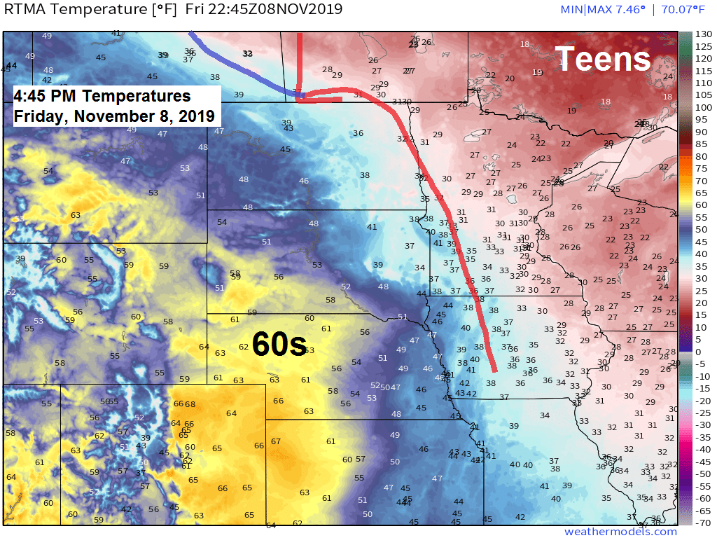
Seeing a nice temperature gradient today with 60s over the Western High Plains and teens over Ontario.
Source: RTMA model; https://lab.weathermodels.com/

Looking at two shots of precipitation through Saturday, the first comes tonight in the form of some light snow, the second may affect parts of the area Saturday afternoon with some light snow or a rain-snow mix.
Radar forecast below is from 6 PM Friday to 6 PM Saturday.
Source: 18z NAM-WRF model; https://weathermodels.com/

Locations that get snow tonight shouldn’t see much accumulation with most of us getting less than an inch of snow, the exception may be along the North Shore into the tip of the Arrowhead where a little lake enhancement may come into play which could boost snow totals into the 1-2 inch range in those areas.

The frigid airmass for early next week has been well advertised by the models for several days now.
Early next week continues to look very cold in the Northland and for many other areas as well.
Source: 12z European model 11.8.2019; https://home.pivotalweather.com/

But by late next week/next weekend the pattern could undergo quite a transition. This is still a ways out so it’s not a lock yet, but model guidance has been showing a more persistent milder weather pattern setting up across the upper Midwest beginning ~November 15th.
Note: The Euro model from Friday is even cooking up a classic Omega Block type of pattern by next weekend where we have strong lows across the eastern US and southwest US while a strong ridge develops in between, if this pattern were to develop, then we could see some real warmth moving into the upper Midwest, perhaps 40s and even 50 degree temps sometime around November 16th-20th.

-The last time we were above freezing in Duluth was on Monday, November 4th. Looks like will finally climb above freezing on Saturday, November 9th.
-On Thursday, International Falls and Hibbing had a top 5 coldest high temperature and a top 5 lowest minimum temperature on record for November 7th.
-On Thursday, Duluth and Ashland had a top 5 coldest high temperature on record for November 7th.
Low temperature reports from around the Northland from Friday morning, November 8, 2019. Source: https://www.weather.gov/dlh/
- 2 E Celina, MN: -5F
- Cotton, MN: -4F
- Hibbing, MN: -3F
- Embarrass, MN: -3F
- Cook, MN: -2F
- Bigfork, MN: -2F
- Eveleth, MN: -1F
- Silver Bay, MN: 0F
- Ely, MN: 0F
- Solon Springs, WI: 0F
- Kabetogama, MN: 0F
- 3 E Orr, MN: 0F
- Floodwood, MN: 1F
- Northome, MN: 1F
- International Falls, MN: 2F
- 3 E Wright, MN: 2F
- Orr, MN: 3F
- Crane Lake, MN: 3F
- Pine River, MN: 3F
- Moose Lake, MN: 3F
- Siren, WI: 3F
- 4 E Island Lake, MN: 3F
- Butternut, WI: 3F
- 4 W Clam Lake, WI: 3F
- Grand Rapids, MN: 4F
- Wolfridge, MN: 4F
- Hayward, WI: 5F
- Aitkin, MN: 5F
- Walker, MN: 5F
- Two Harbors, MN: 7F
- Grand Marais Airport: 7F
- Longville, MN: 7F
- Superior Airport: 7F
- Duluth Airport: 9F
- Hinckley, MN: 9F
- McGregor, MN: 9F
- Brainerd, MN: 10F
- Ashland, WI: 10F
- Duluth Harbor: 10F
- Grand Marais, MN: 12F
Low temperature forecast for Saturday morning, November 9. Source: https://graphical.weather.gov/

High temperature forecast for Saturday, November 9

…Weather Summary…
A little snow tonight followed by milder temperatures for Saturday.
Low pressure over southwest Manitoba will move over Lake Superior on Saturday. A warm front attached to this low will lift through the Nortlhland tonight followed by a cold frontal passage Saturday morning.
A strong baroclinic zone (temperature gradient) is in place today with early evening 850mb temperatures of -10C in far northeast Minnesota to +4C in far western Minnesota to +14C in western Nebraska.
Strong warm air advection centered over the upper Midwest this evening combined with the low and warm front should cause some light snow to break out tonight in parts of the Northland with accumulations of an inch or less.
Lows tonight will be in the teens and 20s with southerly winds this evening shifting to the west/southwest toward dawn.
Expect mostly cloudy to partly sunny skies for Saturday with breezy west to northwest winds of 10 to 20 mph with gusts to 25 mph.
Another disturbance moving S/SE out of the Northern Plains could bring a little snow or a rain-snow mix to parts of the Northland, especially western and southern areas for Saturday afternoon but any precipitation that falls should be light and not amount to much whether it’s snow or rain.
Highs Saturday will range from around 30 degrees in far northern Minnesota to around 40 degrees over southern portions of the area.
Colder air works into the Northland late this weekend with highs Sunday ranging from the lower 20s to lower 30s. Even colder weather for early next week with daytime highs in the teens to around 20 degrees with overnight lows in the single digits below to single digits above zero. Note: Record cold high temperatures are possible in the Northland early next week (November 11th-12th)
Forecast for Duluth and Superior
.Tonight… Mostly cloudy. Light snow or flurries possible. Accumulations less than an inch. Low 20 to 25. Wind south 10 to 15 mph.
.Saturday… Breezy. Mostly cloudy with occasional sunny breaks. A few snow or rain showers possible. High 35 to 40. Wind west 10 to 20 mph with gusts to 25 mph.
.Sunday… Breezy and colder. Partly sunny. A few snow showers and flurries. High 28 to 32. Wind north to northwest 10 to 20 mph.
Normal temperatures for November 9
- High 39
- Low 26
- Sunrise Saturday 7:03 AM CST
- Sunset Saturday 4:42 PM CST
Thanks for reading!
Leave a Reply