The next arctic blast is already moving into the Northland today, and will push well to the south and east over the next few days.
Source: RTMA model; https://lab.weathermodels.com/

Various winter storm warnings and advisories are in effect in parts of the Midwest and near the Great Lakes.
Source: https://www.pivotalweather.com/

Lake effect snow forecast for the South Shore of Lake Superior in northern Wisconsin.

Lake effect snow forecast for north-central Minnesota downwind of the larger inland lakes.

Radar forecast valid from 6 PM Sunday to 6 AM Tuesday.
Scattered snow showers expected in parts of the Northland, especially along the South Shore of Lake Superior and across north-central Minnesota.
Source: 12z NAM-WRF model; https://weathermodels.com/

Low temperature forecast for Monday morning, November 11. Source: https://graphical.weather.gov/

High temperature forecast for Monday, November 11

Note: It’s been a cold stretch in Duluth. The last time we had a daily average temperature which was above normal in Duluth was back on October 26.
Temperature and Precipitation report for Duluth, Minnesota for November 3 through 9, 2019
High Temperatures/Departure from Normal
- 11/3: 36F/-7 degrees below normal
- 11/4: 37F/-5 degrees below normal
- 11/5: 29F/-13 degrees below normal
- 11/6: 26F/-15 degrees below normal
- 11/7: 23F/-17 degrees below normal
- 11/8: 28F/-12 degrees below normal
- 11/9: 34F/-5 degrees below normal
Low Temperatures/Departure from Normal
- 11/3: 22F/-6 degrees below normal
- 11/4: 24F/-4 degrees below normal
- 11/5: 17F/-10 degrees below normal
- 11/6: 16F/-11 degrees below normal
- 11/7: 10F/-17 degrees below normal
- 11/8: 9F/-17 degrees below normal
- 11/9: 24F/-2 degrees below normal
- Total precipitation: 0.07″
- Normal: 0.52″
- Departure: -0.45″ below normal
Temperature departure map for November 3-9, 2019. Source: https://mrcc.illinois.edu/
Very cold pattern continued last week.

Precipitation departure map for November 3-9, 2019.
Dry pattern continued last week.

…Weather Summary…
Frigid weather the next few days with lake effect snow showers along the South Shore of Lake Superior and downwind of the larger lakes in northern Minnesota.
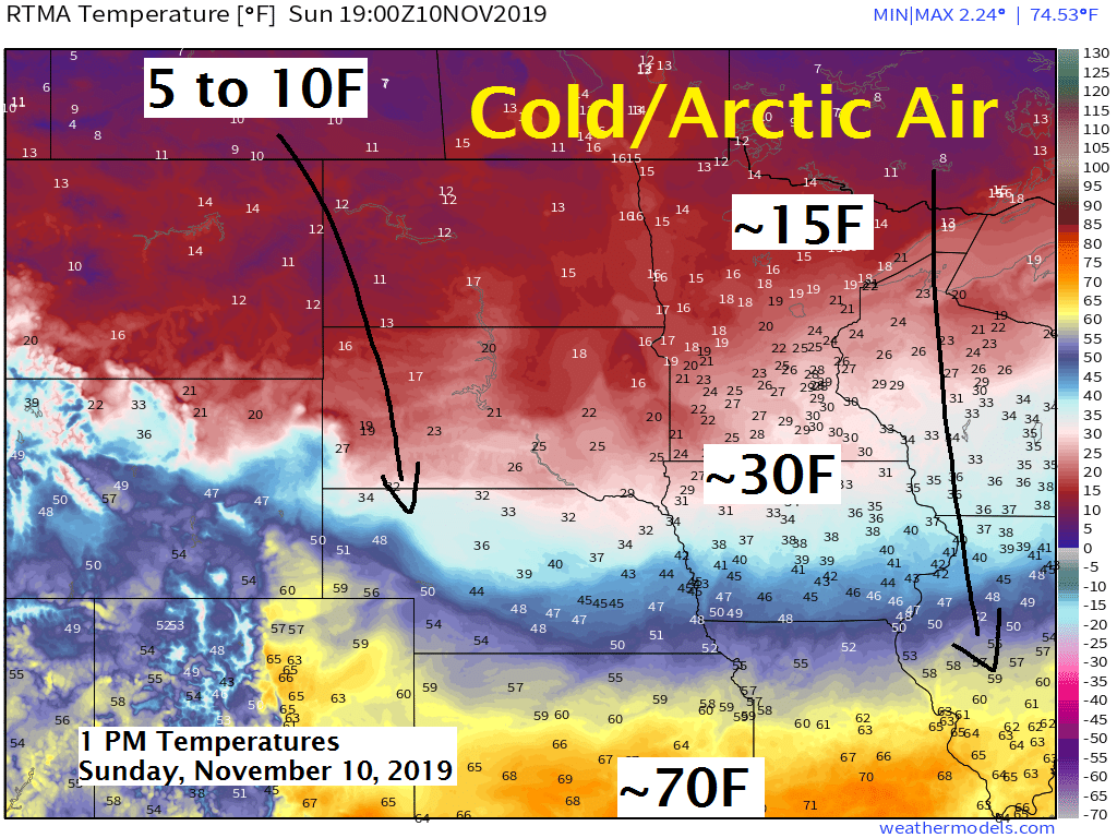
Arctic high pressure averaging 1046mb was over central Alberta this afternoon. Northerly winds and widespread cold temperatures were found east of this high today. 850mb temperatures at 1 PM Sunday ranged from -24C in central Manitoba to -18C in northern Minnesota. Temperatures across the Nortland this Sunday afternoon were only in the middle teens to middle 20s with wind chills ranging from around zero to 15 degrees.
Partly to mostly cloudy skies will be found in the Northland through Tuesday with occasional lake effect snow showers along the South Shore of Lake Superior in northern Wisconsin and also downwind of some of the larger inland lakes across north-central Minnesota including Lake of the Woods, Lake Vermilion, Rainy Lake, Leech Lake and Lake Winnibigoshish, and also off Mille Lacs Lake, although most of that snow should fall south of Aitkin County. 850mb temperatures of around -20 to -25C moving over the milder lake waters will create favorable conditions for lake effect snow with N-NW winds in place.
Outside of the lake effect snow, it looks mainly dry but a few flurries or light snow showers may occur from time to time tonight into Monday.
Lows tonight and Monday night will range from the single digits below to lower teens above zero, but it’s possible that some of the typical cold spots could get as cold as 10 below zero!
Highs on Monday will only be in the teens with record or near record cold high temperatures possible in the Northland for November 11th – See list below.
-International Falls: 9F set in 1995
-Hibbing: 15F set in 1986
-Duluth: 16F set in 1920
-Brainerd: 18F set in 1950, tied in 1986
-Ashland: 20F set in 1950
Little improvement from the very cold temperatures are expected Tuesday with highs in the middle teens to around 20 degrees.
Note: Milder weather is possible beginning next weekend (November 16th) which could last a while with temps at least getting back to where they should be for this time of year, meaning highs in the 30s instead of the teens.
Forecast for Duluth and Superior
.Tonight… Breezy and very cold. Partly to mostly cloudy with a few flurries possible. Low 6 to 10. Wind north to northwest 10 to 20 mph.
.Monday… Breezy and very cold. Partly to mostly cloudy. A few flurries or snow showers possible. High 12 to 16. Wind northwest 10 to 20 mph.
.Tuesday… Partly cloudy. Cold. High 15 to 20. Wind becoming southwest 10 to 15 mph.
Normal temperatures for November 11
- High 38
- Low 24
- Sunrise Monday 7:05 AM CST
- Sunset Monday 4:39 PM CST
Thanks for reading!
Leave a Reply