…Record Cold High Temperatures broken or tied in the Northland today, Monday, November 11th, 2019…
*Hibbing, Minnesota – A new record cold high temperature was set today. New record 9 degrees, old record was 15 degrees set in 1986.
*Brainerd, Minnesota – A new record cold high temperature was set today. New record 14 degrees, old record was 18 degrees which was set in 1950 and tied in 1986.
*Ashland, Wisconsin – A new record cold high temperature was set today. New record 18 degrees, old record 20 degrees set in 1950.
*Duluth, Minnesota – Tied the record cold high temperature of 16 degrees which was set in 1920 (99 years ago)
Late Monday afternoon analysis — strong arctic high pressure over the Northern Plains with widespread cold, arctic air basically anywhere east and north of that blue line on the map.
Source: http://weather.rap.ucar.edu/

Check out this temperature contrast from Monday afternoon!
20s in Oklahoma, 30s in central Texas with 80s in far southern Texas!
Source: RTMA model; https://lab.weathermodels.com/

A classic setup in place early this week to get a blast of arctic air into the US.
Strong upper level low over Ontario with a ridge across the far western US. This sets up a N/NW 500mb flow between the upper low and upper high with the flow coming straight south out of northern Canada.

Radar forecast valid through Noon Wednesday.
Scattered lake effect snow continues into Tuesday morning over parts of the Northland, then we could get a little light snow and flurry action late Tuesday night into Wednesday morning as some ‘warmer’ air moves this way.
Source: 18z NAM-WRF model 11.11.19; https://weathermodels.com/

Low temperature forecast for Tuesday morning, November 12. Source: https://graphical.weather.gov/

High temperature forecast for Tuesday, November 12

I’m continuing to see signs in long range model guidance of a more persistent and milder weather pattern developing in the upper Midwest beginning ~November 16.
The three images below show the temperature anomaly forecast on the dates listed on the maps.
Blue, green and purple colors indicate below to well below normal temperatures.
Orange and red colors indicate above normal temperatures.
Source: 12z European ensemble model 11.11.19; https://weathermodels.com/


Low temperature reports from around the Northland from Monday morning, November 11, 2019. Source: https://www.weather.gov/dlh/
- Silver Bay, MN: -6F
- Cotton, MN: -4F
- Grand Marais Airport: 0F
- Ely, MN: 0F
- 2 E Celina, MN: 0F
- Wolfridge, MN: 0F
- Cook, MN: 1F
- Crane Lake, MN: 1F
- Bigfork, MN: 1F
- Walker, MN: 1F
- Kabetogama, MN: 1F
- Grand Marais, MN: 2F
- International Falls, MN: 3F
- Hibbing, MN: 3F
- Orr, MN: 3F
- Pine River, MN: 3F
- Aitkin, MN: 3F
- Babbitt, MN: 3F
- 4 W Clam Lake, WI: 3F
- Grand Rapids, MN: 4F
- Floodwood, MN: 4F
- 4 E Island Lake, MN: 4F
- Longville, MN: 5F
- Two Harbors, MN: 5F
- 3 E Wright, MN: 5F
- Eveleth, MN: 6F
- Siren, WI: 7F
- Hayward, WI: 8F
- Butternut, WI: 8F
- Winter, WI: 8F
- Duluth Airport: 9F
- Brainerd, MN: 9F
- Moose Lake, MN: 9F
- Superior Airport: 9F
- Solon Springs, WI: 9F
- Hinckley, MN: 10F
- McGregor, MN: 10F
- Duluth Harbor: 12F
- Ashland, WI: 13F
…Weather Summary…
Record setting cold in the Northland today, and it won’t get much better through Tuesday.
High pressure over South Dakota this afternoon is forecast to move SE into Missouri on Tuesday.
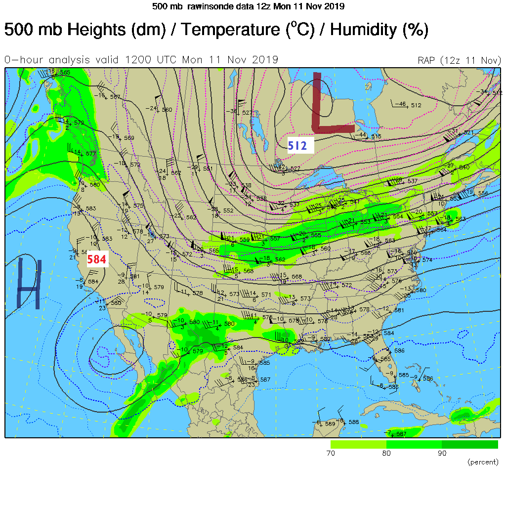
It’s an impressive early season arctic outbreak with RAP model analysis from 5 PM Monday showing -22 to -24C 850mb temperatures over the Northland with 500mb temps down to -44C as far south as northern Lake Superior. 500mb heights were down to 522 decameters which is also a strong indicator of an arctic airmass.
Lake effect snow showers will continue tonight into Tuesday morning along the South Shore of Lake Superior in northern Wisconsin, and downwind of the larger inland lakes in north-central Minnesota. Lake effect snow machine shuts off Tuesday as winds shift to the S-SW.
Outside of the lake effect, the Northland can expect mainly dry weather through Tuesday, but a few flurries can’t be ruled out this evening.
Frigid temperatures tonight with lows in the single digits below to single digits above zero with a few teens below possible in the typical cold spots in northern Minnesota.
Highs Tuesday in the teens to around 20 degrees.
North to northwest winds continue tonight at 5 to 15 mph with winds shifting to the south-southwest Tuesday at 10 to 15 mph.
Warm front builds east out of the Northern Plains Tuesday night with strong warm air advection occurring ahead of this front. 850mb temps across the Northland of -20 to -25C Tuesday morning, climbing to around -2 to -12C by Wednesday morning. Could see some snow break out in parts of the Northland Tuesday night into Wednesday as this warmer air moves in but not expecting much snow accumulation, maybe a half inch at most.
Highs Wednesday will at least make it into the 20s which is still well below normal for this time of year, and Thursday and Friday really aren’t looking that much warmer either, but by this weekend and beyond, more persistent days in the 30s and possibly even in the 40s, also with the milder temperatures comes the risk for a wetter pattern with some snow or rain later this month.
Forecast for Duluth and Superior
.Tonight… Frigid. Partly cloudy with some flurries. Low 1 below to 4 above. Wind northwest 5 to 15 mph.
.Tuesday… Very cold. Partly cloudy. High 15 to 20. Wind becoming south to southwest 5 to 15 mph.
.Wednesday… Mostly cloudy. Light snow showers or flurries possible. High 23 to 27. Wind south becoming west to northwest 10 to 20 mph.
Normal temperatures for November 12
- High 38
- Low 24
- Sunrise Tuesday 7:07 AM CST
- Sunset Tuesday 4:38 PM CST
Thanks for reading!
Leave a Reply