Still looking at a chance for some wet snow and mixed precipitation in northeast Minnesota and northwest Wisconsin for Saturday night into Sunday morning. Note: Significant amounts of snow and ice are not expected, but light amounts of snow and ice may still lead to some travel difficulties Saturday night into Sunday morning.

Radar forecast valid from Noon Saturday to 6 PM Sunday.
Most of the day Saturday looks dry in the Northland with chances for wet snow and mixed precipitation increasing Saturday night followed by lingering areas of snow showers and mixed showers for Sunday.
Source: 18z NAM-WRF model 11.15.19; https://weathermodels.com/

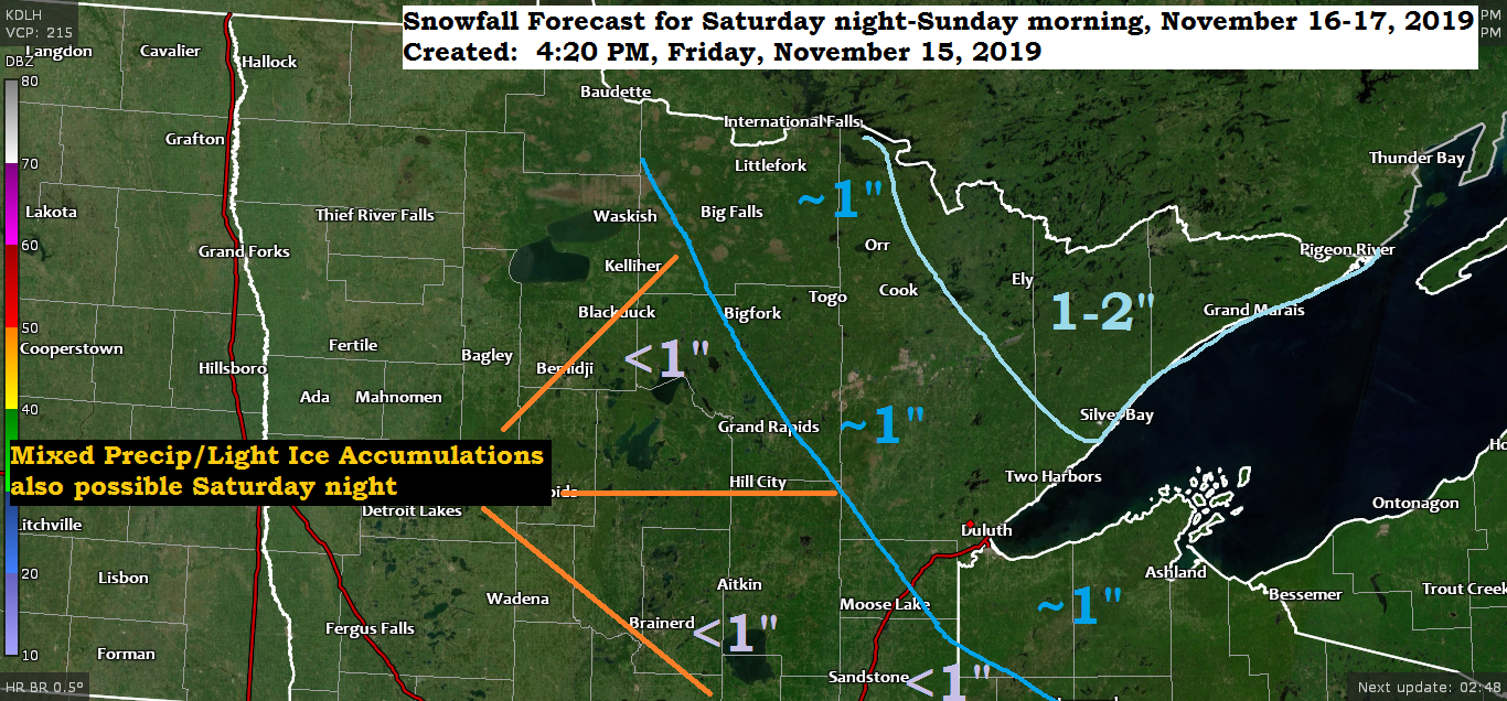
Here’s my updated snowfall forecast for Saturday night-Sunday morning.
Best chances for 1 to 2 inches of snow appears to be over far northeast Minnesota with around an inch of snow possible from International Falls to Duluth to Hayward with less than an inch of snow farther west from the Brainerd Lakes to Hinckely to Siren. Note: Some light ice accumulations are also possible Saturday night over much of the Northland.

Quite a temperature contrast over the Northland today with lower 20s in far northern Minnesota to the low/mid 30s in east-central Minnesota and most of northwest Wisconsin.
Far northern Minnesota is on the southern edge of an arctic airmass which is sliding E-SE across Ontario today with even colder temperatures of around 0 to 15 above located north of our area this afternoon.
Source: RTMA model; https://lab.weathermodels.com/

Low temperature forecast for Saturday morning, November 16. Source: https://graphical.weather.gov/

High temperature forecast for Saturday, November 16

…Weather Summary…
A strong area of high pressure will keep the Northland dry tonight through the day Saturday as it moves from northern Lake Superior to Quebec.
There is an impressive baroclinic zone today (temperature gradient) ranging from -22C in central Quebec to 0C in central Minnesota to +6C in central North Dakota to +12C in southern Montana. Note: The good news if you’re tired of the arctic air is that the pattern will favor milder, near normal temps across the Northland into the middle of next week.
Clear to partly cloudy skies this evening will give way to partly to mostly cloudy skies overnight. Lows will range from the single digits in far northeast Minnesota to the 20s elsewhere. Winds will be out of the east at 5 to 15 mph which may cause a few lake effect flurries along the North Shore of Lake Superior tonight.
Mostly cloudy skies on Saturday with highs in the 30s to lower 40s. Winds will be out of the south at 10 to 20 mph.
Some wet snow and mixed precipitation Saturday night as a cold front moves through the Northland. Lift ahead of this front doesn’t look very impressive, but should be just enough lift to produce some precipitation. There are differences showing up in model guidance today regarding temperatures and precipitation types for Saturday night. The HRRR and RAP models are much warmer on Saturday with widespread 40s over most of the Northland, the warmer temps on those two models causes the majority of the precipitation Saturday night to fall as rain as temps aloft and near the surface remain warm enough for more rain than snow. Other models aren’t as warm as the HRRR and RAP, result from this would be for more snow and mixed precip versus rain.
Sunday looks mostly cloudy with lingering snow showers and mixed showers as low pressure and a cold front exit to the east. Highs on Sunday will mainly be in the 30s (normal for this time of year)
Forecast for Duluth and Superior
.Tonight… Mostly clear this evening. Partly to mostly cloudy overnight. Low 20 to 25. Wind east 10 to 15 mph.
.Saturday… Mostly cloudy. High 35 to 40. Wind south to southeast 10 to 20 mph.
.Saturday night… Mostly cloudy. Light snow or mixed precipitation possible mainly late. Snow accumulations of around an inch or less. Low 30 to 33. Wind south 10 to 15 mph.
.Sunday… Mostly cloudy. Snow showers or drizzle possible. High 34 to 39. Wind southwest 10 to 20 mph becoming northwest later in the day.
| Normal temperatures for November 16 High 35 Low 22 Sunrise Saturday 7:11 AM CST Sunset Saturday 4:34 PM CST Thanks for reading! | |
Leave a Reply