Temperatures in the week ahead should be close to normal or a little above normal in northeast Minnesota and northwest Wisconsin. Note: Normal highs this week are in the low to mid 30s while normal lows are in the middle teens to lower 20s.
Source: 12z European ensemble model 11.17.19; https://weathermodels.com/

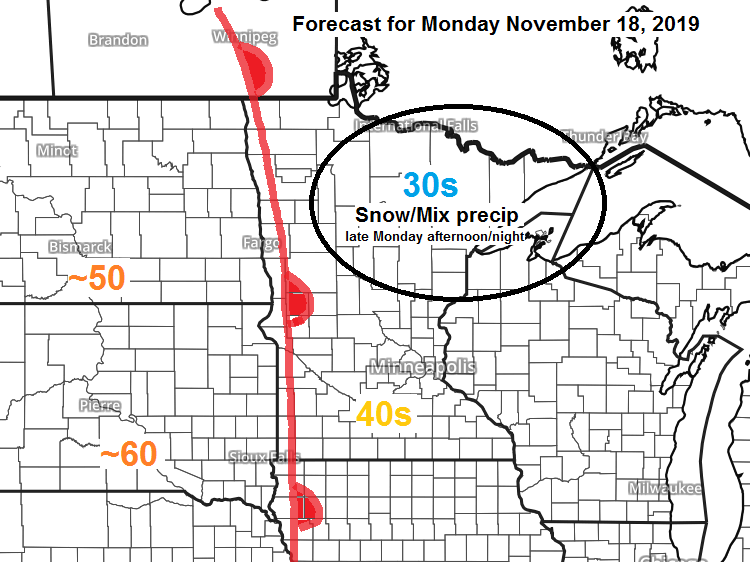
We’ve got another clipper which will affect the Northland from late Monday afternoon into early Tuesday morning. This system will bring a round of light snow and mixed precipitation to most of the Northland during the aforementioned time frame.
50 and 60 degree temperatures Monday afternoon in parts of the Dakotas with 40s to near 50 degree temps in parts of western and southern Minnesota.

Radar forecast valid from Noon Monday to 7 AM Tuesday per 18z NAM-WRF model 11.17.19


Low temperature forecast for Monday morning, November 18. Source: https://graphical.weather.gov/

High temperature forecast for Monday, November 18

Long range forecast models continue to show colder risks developing during the final week of November.
Source: 12z European ensemble model 11.17.19

Temperature and Precipitation report for Duluth, Minnesota for November 10-16, 2019
| High Temperatures/Departure from Normal 11/10: 30F/-9 degrees below normal 11/11: 16F/-22 degrees below normal 11/12: 19F/-19 degrees below normal 11/13: 24F/-13 degrees below normal 11/14: 33F/-3 degrees below normal 11/15: 32F/-4 degrees below normal 11/16: 43F/+8 degrees above normal Low Temperatures/Departure from Normal 11/10: 10F/-15 degrees below normal 11/11: 4F/-21 degrees below normal 11/12: -2F/-26 degrees below normal 11/13: 15F/-8 degrees below normal 11/14: 18F/-5 degrees below normal 11/15: 19F/-3 degrees below normal 11/16: 29F/+7 degrees above normal Average temperature for the week of November 10: 20.7 degrees; -9.5 degrees below normal. Source: https://www.dnr.state.mn.us/ Total Precipitation: 0.12″ Normal: 0.52″ Departure: -0.40″ below normal State Average for Minnesota for the week of November 10, 2019 Temperature: 19.9 degrees Departure: -12.1 degrees below normal Precipitation: 0.04″ Departure: -0.34″ below normal | |
Temperature anomaly map for the week of November 10, 2019.
Source: https://mrcc.illinois.edu/

Precipitation departure map for the week of November 10, 2019.

Snowfall Reports from Sunday morning, November 17, 2019. Source: https://www.weather.gov/dlh/
| Gile, WI: 1.8″ 5 ENE Chief Lake, WI: 1.0″ Duluth Airport: 0.6″ | |
…Weather Summary…
Well today’s weather reminded us that it’s November. A dark and gloomy day across the Northland with extensive low clouds in wake of last night’s system which brought a little wet snow and rain to the area.
Highs today were much cooler compared to Saturday’s ‘balmy’ temps, but today’s highs were very close to normal for mid-November with highs in the upper 20s to upper 30s.
The next few days look mostly cloudy across the Northland but that doesn’t mean we won’t get some breaks in the clouds at times, but overall I wouldn’t expect much sunshine through the middle of the week.
Tonight and most of Monday should be dry with lows tonight in the 20s to around 30 degrees. Highs on Monday will be in the 30s, but lower 40s are possible in far southwest areas (Brainerd Lakes)
Northwest winds tonight at 5 to 15 mph becoming south on Monday at 10 to 20 mph.
A warm front moves east out of the Northern Plains Monday night which will bring a round of wet snow and mixed precip to most of the Northland. This looks like another light precipitation event with no major impacts anticipated at this time, but enough snow could accumulate to cause some issues on the roads in parts of the area Monday night.
Dry weather returns on Tuesday with highs in the 30s to around 40 degrees.
Middle of the week could feature a little snow or mixed precip once again in parts of the Northland as a cold front moves SE across the area while low pressure moves E-NE out of the Rockies/Western High Plains. Note: At the moment it doesn’t look like will get enough phasing to occur in the split flow to give us a more significant snow event, instead it looks like a light snow or wintry mix with no major issues expected at this time for Wednesday into Thursday.
Forecast for Duluth and Superior
.Tonight… Mostly cloudy. Low 24 to 29. Wind northwest at 10 to 20 mph.
.Monday… Mostly cloudy. High 34 to 37. Wind south to southwest 10 to 15 mph.
.Monday night… Light snow possible which could mix with or change to drizzle or freezing drizzle. Snow accumulations of an inch or less. Low 31 to 34. Wind south 10 to 15 mph becoming west late.
.Tuesday… Mostly cloudy. High 35 to 40. Wind west 10 to 20 mph.
Normal temperatures for November 18
| High 34 Low 21 Sunrise Monday 7:16 AM CST Sunset Monday 4:32 PM CST | |
Thanks for reading!
Leave a Reply