| Snowfall Totals from Friday, February 7, 2020 Source: https://www.weather.gov/dlh/ 1 ENE Silver Bay, MN: 5.5″ 3 E Finland, MN: 5.0″ Wolf Ridge, MN: 4.0″ 1 W Silver Bay, MN: 3.8″ Silver Bay, MN: 3.8″ 14 W Isabella, MN: 3.5″ 4.4 WSW Grand Marais, MN: 2.9″ Grand Marais, MN: 2.0″ Duluth Airport: 1.9″ (total thru 5 PM Friday) 25 E Ely, MN: 1.7″ Embarrass, MN: 1.5″ Two Harbors, MN: 1.0″ 7 ESE Superior, WI: 1.0″ |
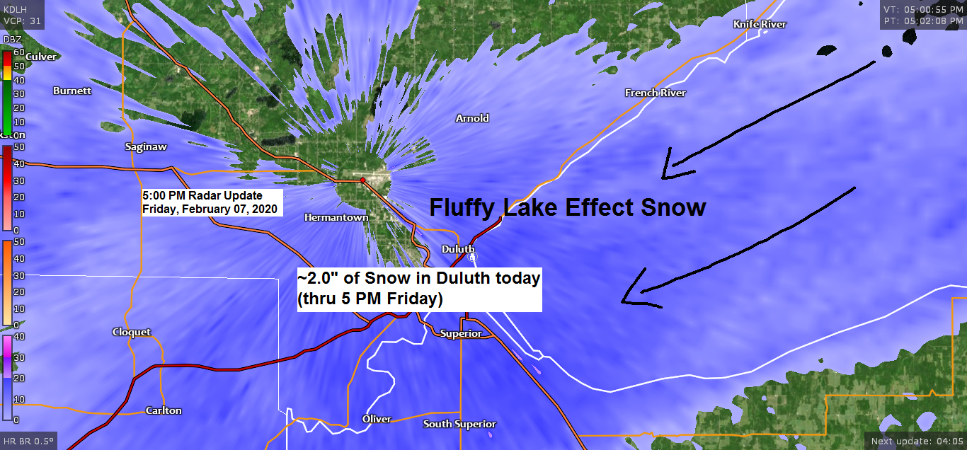
Cold, arctic air moving over the ice-free and relatively warmer waters of Lake Superior caused lake effect snow showers to develop today from Silver Bay and Two Harbors south to the Twin Ports and east along the South Shore. The air mass is plenty cold to produce lake effect snow today with afternoon 850mb temperatures down to -16 to -21C per RAP model analysis.
Goes-16 visible imagery shows the lake effect clouds nicely today as they develop over the lake with movement to the southwest on the NE flow.
Source: https://weather.cod.edu/

Very little water in today’s snowfall, very light and fluffy!
0.04″ QPF at the Duluth Airport with 1.9″ of snow. Snowfall ratio of 47:1 today, incredible!

Source: https://www.spc.noaa.gov/

Arctic air covers parts of the Dakotas into far northern Minnesota today, but this arctic air mass won’t move much farther south/east as it lifts back north into Canada this weekend.
Source: RTMA model; https://lab.weathermodels.com/

No big changes with the track of Sunday’s quick moving winter storm. This system stays well south of the Northland with little if any snow in our area on Sunday.

Winter Storm Watch in effect from late Saturday night through Sunday for far southern portions of Minnesota, parts of South Dakota, Iowa and Wisconsin (blue shaded area on map)
Source: https://home.pivotalweather.com/

The most active weather in terms of larger storm systems are forecast to remain across the southern/eastern portions of the U.S. through the next 2 weeks with above to well above normal precipitation totals.
I’m not seeing any strong signals in model guidance for major winter storms impacting the Northland through the next 2 weeks. Yes, there could be a little snow from time to time, but nothing major the way it looks now.
Source: 12z European ensemble model 2.7.20; https://weathermodels.com/

Low temperature forecast for Saturday morning, February 8th, 2020. Source: https://graphical.weather.gov/

High temperature forecast for Saturday, February 8th, 2020.

…Weather Summary…
Lake effect snow showers really didn’t amount to much today with snowfall totals generally ranging from an inch or two, but with how light/fluffy this snow has been there have been minimal impacts on main roads today, some of this is because the sun is getting stronger this time of the year, even with no sunlight, there’s enough warmth generated by the sun coming through the clouds to melt the snow on main roads, plus treatment on the roads helps as well, just another sign that spring is slowly approaching!
Light lake effect snow showers will linger near Lake Superior tonight with some slick spots possible on the roads. Additional snowfall accumulations tonight will range from a half inch to around 2 inches as the snow that falls is fluffy (larger snowflake size) accumulates quicker than smaller snowflakes.
Very cold in northern Minnesota tonight under mostly clear skies, lows will be in the single digits and teens below zero with even some 20s below possible. A little warmer elsewhere with lows tonight in the single digits to around 10 above zero. Winds tonight will be out of the north or northeast at 5 to 15 mph.
High pressure moves over the upper Midwest on Saturday. Can’t rule out a few flurries, but overall it looks dry in our area with highs in the teens to lower 20s. Winds will shift to the south or southwest at 5 to 15 mph.
Partly to mostly cloudy on Sunday. A little light snow/flurries are possible over far southern areas of the Northland (Pine City to Hayward line) Highs on Sunday will be in the 20s with north to northwest winds 10 to 20 mph.
A few minor snow events are possible for next week, but no major storms affecting the Northland the way it looks now. The week will start mild, but a brief arctic dump is possible later next week.
Forecast for Duluth and Superior
.Tonight… Snow showers mainly before Midnight. Additional snowfall accumulations of 0.5 to 2.0 inches possible. Mostly cloudy. Low 3 to 8. Wind east to northeast 5 to 15 mph becoming light and variable.
.Saturday… Partly to mostly cloudy. High 17 to 22. Wind south to southwest 10 to 15 mph.
.Sunday… Partly to mostly cloudy. High 20 to 25. Wind north to northwest 10 to 20 mph.
| Normal temperatures for February 8 High 22 Low 4 Sunrise Saturday 7:24 AM CST Sunset Saturday 5:22 PM CST |
Thanks for reading!
Tim
Leave a Reply