A swath of 6 to 8 inch plus snowfall amounts are likely by late Sunday afternoon across south-central Minnesota into central Wisconsin. Snowfall totals will taper off quickly farther north with only around an inch of snow possible from Hinckley to Hurley, with a band of 2 to 4 inches of snow south of the Hayward area on Sunday.
Source: 12z HREF model 2.8.2020; https://www.spc.noaa.gov/

Only far southern portions of the Northland can expect a little snow on Sunday, roughly along and south of a line from Hinckley to Ashland.
Source: 12z HREF model 2.8.2020

Winter storm which will impact southern Minnesota and central/southern Wisconsin on Sunday is currently over the Northern Rockies this afternoon and is moving to the east/southeast per Goes-16 water vapor imagery.
Source: https://weather.cod.edu/

A strong temperature gradient is in place for Sunday’s storm with cold, arctic air over Ontario while warmer air lifts north out of the Central Plains.

Sunday’s storm will be a quick hitter, but snow will fall heavily for roughly 6 hours with potential for 1 to 2 inch per hour snowfall rates across southern Minnesota
Radar forecast below is valid from 6 PM this evening to 6 PM Sunday. Snow spreads into southwest Minnesota later this evening, then across all of southern Minnesota early Sunday morning. Snow is forecast to end Sunday afternoon from west to east.
Source: 18z NAM/WRF model 2.8.2020; https://weathermodels.com/

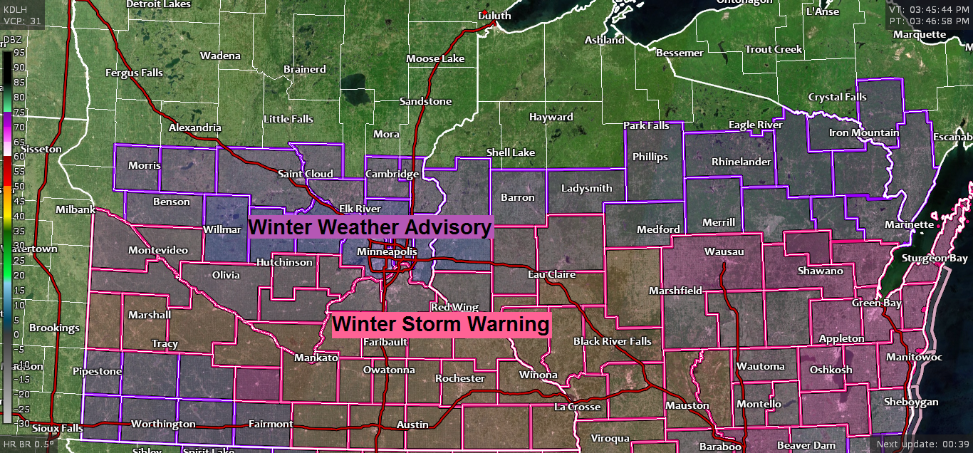
Winter Storm Warnings (pink) and Winter Weather Advisories (purple) are in effect for central and southern portions of Minnesota and Wisconsin from late tonight through Sunday afternoon.

Road Conditions
Minnesota – https://lb.511mn.org/
Wisconsin – https://511wi.gov/
Low temperature forecast for Sunday morning, February 9th, 2020. Source: https://graphical.weather.gov/

High temperature forecast for Sunday, February 9th, 2020.

Arctic blast is possible late next week, ~February 13 and 14, but similar to past arctic air masses this winter, this one also looks brief, only sticking around 2 days before moving away next weekend the way it looks now.
Source: 12z European computer model 2.8.2020; https://www.tropicaltidbits.com/

Low Temperature reports from Saturday morning, February 8th, 2020.
Source: https://www.weather.gov/dlh/
| 25 E Ely, MN: -31F Seagull Lake, MN: -30F Ash Lake, MN: -27F Crane Lake, MN: -26F Cook, MN: -26F Bigfork, MN: -26F Orr, MN: -24F International Falls, MN: -24F Chisholm-Hibbing Airport: -23F Hill City, MN: -22F Ely, MN: -22F Pine River, MN: -20F Longville, MN: -20F Cotton, MN: -19F Deer River, MN: -18F Aitkin, MN: -18F Grand Marais Airport: -18F Grand Rapids, MN: -17F Brainerd, MN: -15F McGregor, MN: -15F Babbitt, MN: -13F 3 E Wright, MN: -11F |
…Weather Summary…
Will have mostly cloudy to partly cloudy skies in the Northland tonight and Sunday with some flurries or light snow showers possible at times. Only light snowfall accumulations are expected on Sunday, and that should be confined to far southern areas from Hinckley to Ashland and points south.
Lows tonight will be in the single digits below zero to lower teens above zero. Highs on Sunday will be in the mid teens to mid 20s. Winds out of the southwest tonight will become north on Sunday at 10 to 20 mph.
A few minor snow events could affect the Northland next week, one in the Monday-early Tuesday time frame, the other on Wednesday. Behind that midweek system will be a shot of bitter cold air, and this air mass could push far enough south to affect the Northland late next week with potential for subzero daytime highs, and overnight lows in the teens, 20s and 30s below zero. Note: Dangerously cold wind chills are also possible late next week. Stay tuned.
Computer models do show a rather significant warm-up taking place later this month, beginning ~February 19th, this will be something to watch going forward to see if models continue to show this, or do they back away from it?
Forecast for Duluth and Superior
.Tonight… Mostly cloudy. A few flurries possible. Low 6 to 11. Wind southwest around 10 mph.
.Sunday… Partly to mostly cloudy. Flurries possible. High 20 to 25. Wind north 10 to 20 mph.
.Monday… Partly to mostly cloudy. High 25 to 30. Wind southwest 10 to 20 mph.
| Normal temperatures for February 9 High 22 Low 4 Sunrise Sunday 7:23 AM CST Sunset Sunday 5:24 PM CST |
Thanks for reading!
Tim
Leave a Reply