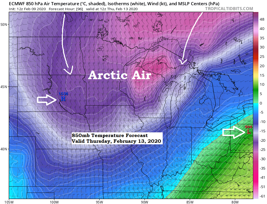
Pattern still looks favorable for a brief shot of arctic air across the upper Midwest and Great Lakes for late this week.
Source: 12z European model 2.9.2020; https://www.tropicaltidbits.com/

Dangerously cold wind chills are possible across the upper Midwest from Wednesday night through Friday morning. Wind chill headlines may be needed for later this week.
Source: 12z European model 2.9.2020; https://weathermodels.com/

Here’s a look at today’s winter storm which hit southern Minnesota and central/southern Wisconsin per Goes-16 infrared satellite imagery.
Note: Colder cloud tops show up as green and yellow colors on the image below.

Saw some very intense snow bands across southern Minnesota this morning with hourly snowfall rates of 1 to 2 inches, and even some thundersnow! Check out the lightning strikes that occurred this Sunday morning in southern Minnesota (orange and red dots on map)
Source: https://www.lightningmaps.org/

Source: https://www.weather.gov/mpx/
| Here are a few snowfall reports from southern Minnesota today. Lake Crystal, MN: 15.5″ Lucan, MN: 13.5″ St. James, MN: 12.5″ 2 ESE Mankato, MN: 11.5″ New Ulm, MN: 11.0″ 1 NE Owatonna, MN: 10.3″ Waseca, MN: 10.0″ Brownsville, MN: 8.8″ Jordan, MN: 7.0″ Apple Valley, MN: 6.5″ |

Low temperature forecast for Monday morning, February 10th, 2020. Source: https://graphical.weather.gov/

High temperature forecast for Monday, February 10th, 2020.

| Temperature and Precipitation report for Duluth, Minnesota for the week of February 2nd, 2020. High Temperatures/Departure from Normal 2.2: 39F/+18 degrees above normal 2.3: 31F/+10 degrees above normal 2.4: 14F/-7 degrees below normal 2.5: 28F/+7 degrees above normal 2.6: 28F/+6 degrees above normal 2.7: 22F/Normal 2.8: 18F/-4 degrees below normal Low Temperatures/Departure from Normal 2.2: 26F/+24 degrees above normal 2.3: 5F/+2 degrees above normal 2.4: -4F/-7 degrees below normal 2.5: 0F/-3 degrees below normal 2.6: 8F/+5 degrees above normal 2.7: 9F/+5 degrees above normal 2.8: 0F/-4 degrees above normal Note: Average temperature in Duluth for the week of February 2nd, 2020: 16.0 degrees; +3.8 degrees above normal. Source: https://www.dnr.state.mn.us/ Total Precipitation: 0.04″ Normal: 0.17″ Departure: -0.13″ below normal State Average for Minnesota for the week of February 2nd, 2020. Temperature: 18.2 degrees Departure: +4.8 degrees above normal Precipitation: 0.03″ Departure: -0.11″ below normal |
Average temperature, departure from mean for the week of February 2nd, 2020. Source: https://mrcc.illinois.edu/

Total precipitation, departure from mean for the week of February 2nd, 2020.

…Weather Summary…
Clear to partly cloudy skies tonight with lows in the single digits below zero to around 10 above zero. Winds becoming southwest around 10 mph.
Partly to mostly cloudy skies on Monday with a shot of light snow spreading E-SE out of northern Minnesota sometime in the afternoon or evening, this snow won’t amount to much with accumulations less than an inch. Milder on Monday with highs in the 20s to around 30 degrees. Winds south-southwest 10 to 20 mph.
Cold front moves through the Northland Monday night, winds shift from SW to NW once the front passes. A few flurries or snow showers continue Monday night. Lows will be in the teens.
Tuesday looks dry with highs in the 20s.
Snow chances return Wednesday into early Thursday as an arctic front moves through the area, but once again snowfall amounts look to be on the light side, maybe an inch or two if it snows long enough.
Computer models remain in good agreement in shoving an arctic air mass south into our area for Thursday and Friday resulting in daytime highs in the single digits below to single digits above zero with lows in the teens, 20s and 30s below for Thursday morning and again Friday morning. Milder temperatures return by the weekend, with a real nice warm-up (highs 35 to 45) possible beginning ~February 19th.
Forecast for Duluth and Superior
.Tonight… Mostly clear. Low 5 to 10. Wind northwest 5 to 15 mph becoming southwest late.
.Monday… Partly to mostly cloudy. Light snow showers or flurries possible mainly during the late afternoon or evening hours. High 26 to 31. Wind south to southwest 10 to 20 mph.
.Tuesday… Partly cloudy. High 23 to 28. Wind southwest 10 to 20 mph.
| Normal temperatures for February 10 High 23 Low 4 Sunrise Monday 7:21 AM CST Sunset Monday 5:25 PM CST |
Thanks for reading!
Tim
Leave a Reply