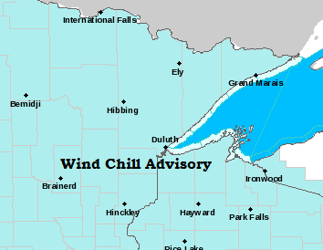
-Wind Chill Advisory in effect from 8 PM this evening to 9 AM Friday for all of northeast Minnesota and northwest Wisconsin including the cities of International Falls, Bigfork, Grand Rapids, Walker, Brainerd, Aitkin, Hill City, Hinckley, Cloquet, Duluth, Hibbing, Ely, Grand Marais, Silver Bay, Two Harbors, Superior, Ashland, Hurley, Grantsburg, Shell Lake and Hayward.
-Wind chills as low as 30 to 40 degrees below zero. The dangerously cold wind chills could cause frostbite on exposed skin in as little as 10 minutes.
Source: https://www.weather.gov/dlh/

Arctic air mass moving over the warmer and mostly ice-free waters of Lake Superior (Ice coverage <10% as of Thursday morning) is generating widespread lake effect clouds today. Northwest winds carry these lake effect clouds and in some areas snow showers downwind of Lake Superior, along the South Shore from northern Wisconsin to Upper Michigan.
Water temps over Lake Superior are right around +1C (34F) while the air crossing over the lake consists of 850mb temperatures of -25C (-13F) today.

Arctic air will remain over the Northland through Friday morning, but a milder air mass will begin to work into the Northland Friday afternoon.
Source: https://www.spc.noaa.gov/

| Low Temperature Reports from around the Northland for Tuesday morning, February 13th, 2020. Source: https://www.weather.gov/dlh/ Kabetogama, MN: -39F 25 E Ely, MN: -37F 14 W Isabella, MN: -37F Babbitt, MN: -36F Crane Lake, MN: -36F Cotton, MN: -33F Embarrass, MN: -31F Cook, MN: -29F Bigfork, MN: -29F Northome, MN: -28F International Falls, MN: -28F Cass Lake, MN: -27F Deer River, MN: -27F Ely, MN: -26F Saginaw, MN: -24F Hill City, MN: -24F Hibbing, MN: -24F Aitkin, MN: -24F Grand Marais Airport: -24F Pine River, MN: -24F Duluth Airport: -21F Hermantown, MN: -21F Brainerd, MN: -21F Esko, MN: -20F Cloquet, MN: -20F McGregor, MN: -20F Moose Lake, MN: -20F South Range, WI: -19F Hinckley, MN: -17F Superior Airport: -17F Minong, WI: -17F Siren, WI: -16F Duluth Harbor: -15F Hayward, WI: -13F |
| Minimum Wind Chill Reports from around the Northland for Tuesday morning, February 13th, 2020. Source: https://www.weather.gov/dlh/ Grand Marais Airport: -49F Grand Rapids, MN: -43F International Falls, MN: -43F Orr, MN: -43F Cook, MN; -42F Duluth Airport: -41F Ely, MN: -41F Longville, MN: -40F Pine River, MN: -39F Aitkin, MN: -38F Cloquet, MN: -38F Duluth Harbor: -37F Brainerd, MN: -36F Bigfork, MN: -36F Superior Airport: -36F Minong, WI: -34F Siren, WI: -31F Esko, MN: -30F |
Low temperature forecast for Friday morning, February 14th, 2020. Source: https://graphical.weather.gov/

High temperature forecast for Friday, February 14th, 2020.

Another day of model runs and I’m still seeing quite a bit of uncertainty in the temperature forecast for next week per EPS and GEFS models.
The strength of next week’s arctic air mass may have something to do with the different model solutions.
About the only areas where there is good model agreement is over the Central/Southern Rockies into the Southern Plains, and also in Florida.
No model agreement on the temperature forecast for next week from the Northern Plains to upper Midwest, north into Canada.
Source: 12z European ensemble model 2.13.2020; https://weathermodels.com/

Source: 12z GEFS model 2.13.2020; https://www.tropicaltidbits.com/

…Weather Summary…
A quiet weather pattern continues through the weekend.
Very cold once again tonight under clear to partly cloudy skies. Lows will be in the teens, 20s and 30s below with winds shift from west-northwest to southwest.
Mostly sunny to partly cloudy on Friday. Temperatures warm into the teens to around 20 degrees by late afternoon, below normal for mid February, but warmer than it was today. Winds will be out of the south at 10 to 20 mph.
Note: There could be a brief opportunity for some light lake effect snow along the North Shore on Friday, mainly from Silver Bay to Grand Marais due to the southerly wind, but with warm air advection moving in, this should limit the duration of any lake effect snow.
A warm front and cold front move across the Northland Friday night and Saturday. A few snow showers or flurries are possible with this system, but little if any accumulation is expected. Highs on Saturday are forecast to be in the middle 20s to lower 30s.
Colder air follows for Sunday with highs dropping back to the single digits and teens, and it’s looking increasingly likely that will see another arctic shot sometime around February 19th, although it doesn’t look quite as cold as this current arctic blast.
Forecast for Duluth and Superior
*Wind Chill Advisory 8 PM tonight to 9 AM Friday*
.Tonight… Bitterly cold. Mostly clear. Low 16 below to 21 below. Wind west 5 to 15 mph becoming southwest. Wind chills 30 below to 40 below.
.Friday… Partly cloudy. High 13 to 18. Wind south to southwest 10 to 20 mph. Morning wind chills 30 below to 40 below.
.Saturday… Partly to mostly cloudy. High 26 to 31. Wind west 10 to 20 mph.
| Normal temperatures for February 14 High 24 Low 6 Sunrise Friday 7:15 AM CST Sunset Friday 5:31 PM CST |
Thanks for reading!
Tim
Leave a Reply