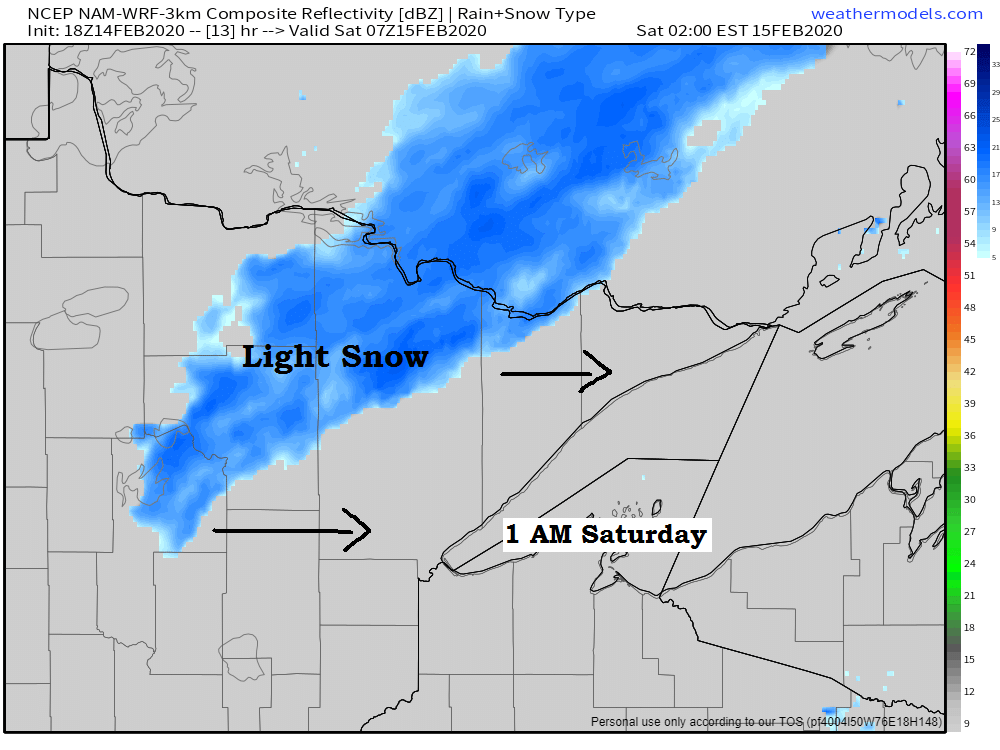
Could see a little snow in northern Minnesota late tonight/early Saturday morning as a warm front moves east out of the Dakotas. Not looking at much accumulation, maybe a half inch to inch of snow (north of Duluth)
Source: 18z NAM-WRF model 2.14.2020; https://weathermodels.com/

Computer models are in good agreement in shoving another lobe of arctic air south into the Northland for the middle of next week, but this will likely be the last of the arctic air we see this winter considering the unofficial end to winter 2019-2020 is coming up fast (February 29th)
Source: 12z European model 2.14.2020; https://www.tropicaltidbits.com/

| Low Temperature Reports from around the Northland for Friday morning, February 14th, 2020. Source: https://www.weather.gov/dlh/ Cotton, MN: -39F 3 E Orr, MN: -35F Embarrass, MN: -34F Silver Bay, MN: -31F Hibbing, MN: -30F Eveleth, MN: -29F Ely, MN: -29F Cook, MN: -29F Glidden, WI: -26F Bigfork, MN: -26F International Falls, MN: -25F Moose Lake, MN: -24F Two Harbors, MN: -24F South Range, WI: -22F Glidden, WI: -22F Minong, WI: -20F Hayward, WI: -20F Ashland, WI: -20F Duluth Airport: -16F Superior Airport: -14F Duluth Harbor: -11F |
Low temperature forecast for Saturday morning, February 15th, 2020. Source: https://graphical.weather.gov/

High temperature forecast for Saturday, February 15th, 2020.

I’m not sure why there continues to be such a large spread in temperature forecasts for next week in the long range model guidance.
Both models (EPS and GEFS) show an arctic air mass affecting the Northland the middle of next week, but they also show a much warmer pattern setting up by February 22nd, yet the Euro ensemble (EPS) isn’t nearly as cold as the GEFS model continues to be, and the greatest area of uncertainty in the two models shown below continues to be over Canada, Northern Plains and upper Midwest. Interesting!
Source: 12z European ensemble model 2.14.2020; https://weathermodels.com/

Source: 12z GEFS model 2.14.2020; https://www.tropicaltidbits.com/

I’m noticing a trend in the Euro ensemble model which may support storm development over the Plains toward the end of the month, quite a few moving parts showing up here so nothing is certain at this point, but something to keep an eye for around February 25th and beyond.
Source: 12z European ensemble model 2.14.2020; https://weathermodels.com/

It does look like will have a warmer end to February, in fact we may have a few days that have highs of 40 or above in the Northland beginning next weekend (February 22nd)
Source: 12z European ensemble model 2.14.2020

…Weather Summary…
Well we made it through what was likely the coldest air mass will see this winter, congrats!
A brief warm up is underway as arctic high pressure moves into the Ohio Valley, this puts our area in a strong warm air advection pattern on the NW side of that high. 850mb temperatures as of 5 PM Friday ranged from -10C in the tip of the Minnesota Arrowhead to 0C in extreme southwest Minnesota.
A warm front over the Dakotas will move through the Northland late tonight/Saturday morning with increasing cloudiness along with some light snow or patchy freezing drizzle in parts of the area as that boundary moves through overnight into Saturday morning. Snowfall accumulations of an inch or less are possible through Saturday morning in far northern Minnesota (north of Duluth)
Lows tonight will be in the single digits and teens with south winds 10 to 20 mph with higher gusts possible thanks to a strong low level jet of 50 to 60 knots which will be over the Northland through the evening.
Cold front moves through the area Saturday afternoon/evening with a few flurries or snow showers possible under partly to mostly cloudy skies. Highs on Saturday will be in the 20s to lower 30s with a breezy west wind 10 to 20 mph with higher gusts.
Colder air spills south into the Northland for Saturday night and Sunday in wake of the aforementioned cold frontal passage. Lows Saturday night are forecast to range from the teens below to single digits above zero with highs on Sunday in the single digits and teens.
Light snow chances return for Sunday night and Monday, but this doesn’t look like a big system, in fact it looks very unorganized until it reaches the Eastern Great Lakes, and by that time all the snow will be long gone. Right now I’m leaning toward a dusting to inch of snow with Monday’s event given how poorly the models have been doing with systems that have affected us lately.
Forecast for Duluth and Superior
.Tonight… Breezy. Increasing cloudiness. Flurries possible overnight. Low 8 to 12. Wind south 10 to 20 mph with higher gusts possible.
.Saturday… Breezy. Partly to mostly cloudy. Flurries possible early. High 29 to 33. Wind becoming west 15 to 25 mph.
.Sunday… Partly cloudy. Colder. High 12 to 17. Wind northwest 10 to 15 mph.
| Normal temperatures for February 15 High 24 Low 6 Sunrise Saturday 7:14 AM CST Sunset Saturday 5:33 PM CST |
Thanks for reading!
Tim
Leave a Reply