A quick blast of arctic air will move over the Northland late tonight into Sunday. Temperatures won’t be as cold as they were with the previous arctic blast a few days ago, but temperatures will be a good 10 to 20 degrees colder Sunday compared to Saturday’s high temperatures.
Source: RTMA model 2.15.2020; https://lab.weathermodels.com/

Source: 4 PM RAP model; https://www.spc.noaa.gov/

Low temperature forecast for Sunday morning, February 16th, 2020. Source: https://graphical.weather.gov/

High temperature forecast for Sunday, February 16th, 2020.

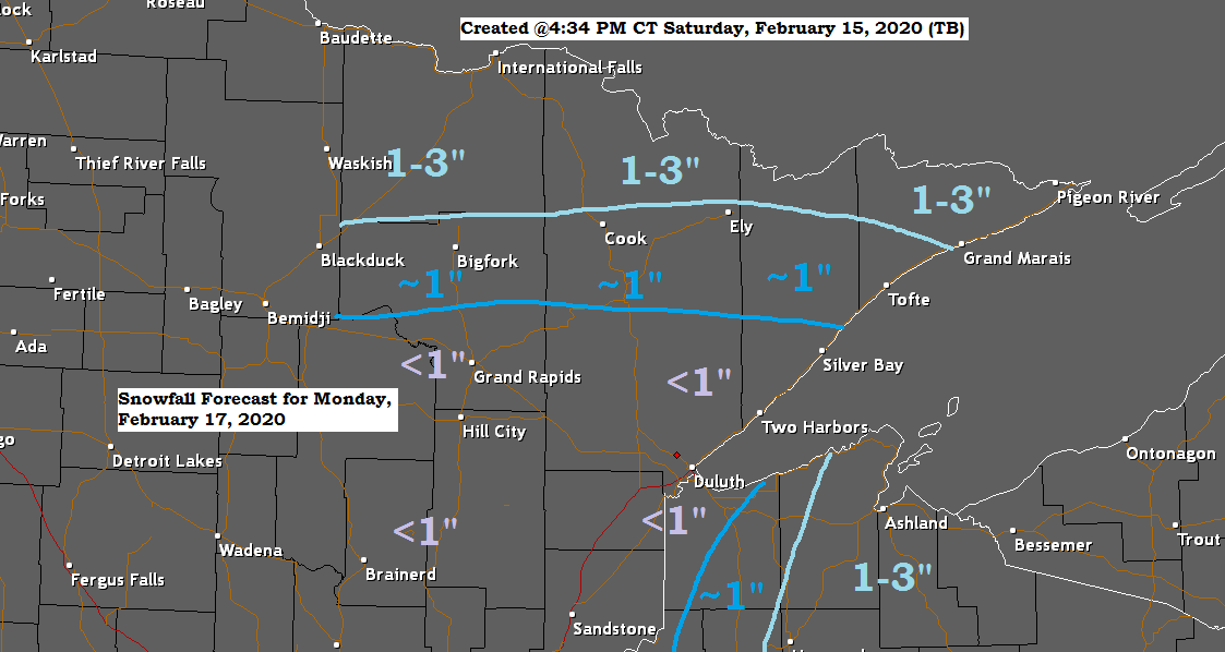
I’m still not impressed at all with Monday’s system, looks very messy/unorganized until it passes well off to our east.
Looks like we may see two areas with possibly 1 to 3 inches of snow on Monday, one in far northern Minnesota, the other in eastern portions of northwest Wisconsin. Elsewhere it looks like a few tenths to an inch of snow on Monday.

This is just a heads up since we’re talking about something that is at least 10 days out, but the pattern in which the computer models have been showing lately for the end of February is one that could feature a more significant low pressure system/s coming out of the Rockies or Plains toward the end of the month. Still a great deal of uncertainty regarding the timing, track and strength of this system/s, but stay tuned!
Note: If this storm does develop and it tracks far enough north, then it could bring snow, mix precipitation or even rain, or all three precipitation types to northeast Minnesota and northwest Wisconsin sometime in the February 24-28 time frame.

…Weather Summary…
Arctic front will continue to move SE through the Northland tonight. Partly to mostly cloudy skies will be found in the area tonight with a few flurries possible. Blustery northwest winds 10 to 20 mph with higher gusts. Lows will drop into the single digits and teens below zero with 20s and maybe even a 30 below zero temperature in northern Minnesota.
Arctic high pressure moves quickly through the upper Midwest on Sunday with mainly dry weather during the day under partly to mostly cloudy skies. Highs will be in the single digits and teens with variable winds which will gradually shift to the south.
Chances for some light snow for Sunday night and Monday as warmer air moves east into the upper Midwest while low pressure moves SE out of the Northern Plains. Highs on Monday are forecast to be in the 20s to around 30 degrees.
Will turn colder again Tuesday, Wednesday and Thursday as one last lobe of arctic air swooshes south into the Northland. Note: Wind chill headlines may be needed for parts of the Northland the middle of next week.
A much warmer pattern looks to develop by next weekend, in fact it looks we could have highs near 40 or well into the 40s in most of the Northland next Saturday and Sunday (February 22-23)
Forecast for Duluth and Superior
.Tonight… Breezy and turning colder. Partly to mostly cloudy. Low 5 below to 10 below. Wind west to northwest 10 to 20 mph with higher gusts possible.
.Sunday… Colder. Partly to mostly cloudy. High 12 to 15. Wind northwest 5 to 15 mph becoming south.
.Monday… Mostly cloudy. Light snow or flurries possible. Snowfall accumulations less than an inch. Milder. High 23 to 28. Wind southeast 5 to 15 mph.
| Normal temperatures for February 16 High 24 Low 6 Sunrise Sunday 7:12 AM CST Sunset Sunday 5:34 PM CST |
Thanks for reading!
Tim
Leave a Reply