Light snow moves into north-central Minnesota later tonight and will spread farther east Monday morning.
Light snow ends from west to east Monday afternoon.
Here’s a look at the 18z NAM-WRF model radar forecast valid from 6 PM Sunday to 6 PM Monday.
Source: https://weathermodels.com/

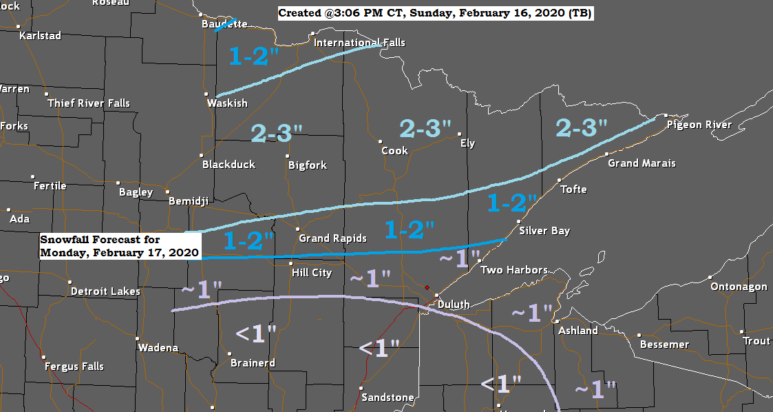
Here’s my updated snowfall forecast for Monday’s event.
*Highest amounts of 2 to 3 inches in northern Minnesota roughly north of a line from Walker to Hibbing to Grand Marais.
*1 to 2 inches of snow for International Falls, Grand Rapids and Silver Bay.
*Around an inch or less of snow for the rest of the Northland including for Duluth and Superior.

With the colder temperatures recently, ice coverage on Lake Superior has increased to ~17% (16.8%) as of Sunday morning, February 16th, 2020.
Source: https://www.glerl.noaa.gov/

Lake Superior ice coverage for 2020 is still running well behind where it should be though for mid-February.
1973-2019 average for mid-February is 40 to 45%, we’re sitting ~17% in 2020.
Source: https://coastwatch.glerl.noaa.gov/

Although much of this week will be on the chilly side, especially from Tuesday through Thursday, a milder air mass is forecast to spread into the upper Midwest later this week into next weekend with potential for daytime highs of 40 degrees or warmer in the Northland next weekend (February 22-23)
Source: 12z European model 2.16.2020; https://www.ecmwf.int/

Still looking at a possible storm coming out of the Rockies and Plains sometime in the February 24 to 28 time frame. The track, timing and intensity of this system will change daily since this system is still over a week out, but the overall pattern in which the computer models have been showing for late month is one that would support storm development over the Rockies and Plains, whether or not this system impacts the Northland is highly uncertain at this time, but if it does take a favorable track, then we could see some snow, rain and mixed precipitation in northeast Minnesota and northwest Wisconsin sometime in the February 24-28 time frame. Stay tuned.

Low temperature forecast for Monday morning, February 17th, 2020. Source: https://graphical.weather.gov/

High temperature forecast for Monday, February 17th, 2020.

| Temperature and Precipitation report for Duluth, Minnesota for the week of February 9th, 2020. High Temperatures/Departure from Normal 2.9: 20F/-2 degrees below normal 2.10: 25F/+2 degrees above normal 2.11: 25F/+2 degrees above normal 2.12: 25F/+2 degrees above normal 2.13: 0F/-23 degrees below normal 2.14: 15F/-9 degrees below normal 2.15: 30F/+6 degrees above normal Low Temperatures/Departure from Normal 2.9: 2F/-2 degrees below normal 2.10: 3F/-1 degree below normal 2.11: 16F/+11 degrees above normal 2.12: -13F/-18 degrees below normal 2.13: -21F/-26 degrees below normal 2.14: -16F/-22 degrees below normal 2.15: 8F/+2 degrees above normal Note: Average temperature in Duluth for the week of February 9th: 8.5 degrees; -5.5 degrees below normal. Note: First below average week in Duluth since the week of January 12th. Total Precipitation: 0.01″ Normal: 0.17″ Departure: -0.16″ below normal State Average for Minnesota for the week of February 9th, 2020. Source: https://www.dnr.state.mn.us/ Temperature: 8.9 degrees Departure: -6.8 degrees below normal Precipitation: 0.25″ Departure: +0.11″ above normal |
Average temperature, departure from mean for the week of February 9th, 2020. Source: https://mrcc.illinois.edu/

Total precipitation, departure from mean for the week of February 9th, 2020.

| Coldest weeks of the 2019-2020 Meteorological Winter season at Duluth, Minnesota. Note: Meteorological winter is the period from December 1st to February 28th. 1) December 8-14: Average temperature of 8.1 degrees; -8.0 degrees below normal. 2) February 9-15: Average temperature of 8.5 degrees; -5.5 degrees below normal. 3) December 15-21: Average temperature of 9.5 degrees; -4.2 degrees below normal. |
| Low Temperature reports from around the Northland for Sunday morning, February 16th, 2020. Source: https://www.weather.gov/dlh/ Kabetogama, MN: -28F International Falls, MN: -28F Crane Lake, MN: -22F Babbitt, MN: -22F Cotton, MN: -21F Embarrass, MN: -21F Bigfork, MN: -18F Cook, MN: -17F Ely, MN: -15F Orr, MN: -13F Grand Marais Airport: -11F Hibbing, MN: -10F 4 W Clam Lake, WI: -10F Duluth Airport: -4F |
…Weather Summary…
Clouds will be on the increase tonight with some snow developing early Monday morning across north-central Minnesota (west/north of Duluth) Lows tonight will be in the single digits below to around 10 above with winds out of the east or southeast at 5 to 15 mph.
Mostly cloudy skies for Monday with some light snow and patchy freezing drizzle. One piece of energy moving across northern Minnesota Monday morning will support an area of accumulating snow, while a second piece of energy moving NE out of Iowa produces another area of accumulating snow during the afternoon and evening mainly south/east of the Northland, although the NW side of this snow shield may clip eastern portions of northwest Wisconsin (Hayward and Hurley areas) Highs on Monday will be in the 20s to around 30 degrees with east or south winds shifting to northwest late in the day.
A stretch of dry weather is then expected starting on Tuesday which should linger into next weekend the way it looks now. Will start cold with daytime highs in the single digits and teens for Tuesday, Wednesday and Thursday with subzero overnight temperatures likely along with very cold wind chills. Temperatures will warm up starting Friday with temperatures climbing toward or above the freezing mark by Friday afternoon.
Forecast for Duluth and Superior
.Tonight… Increasing cloudiness. Low 2 to 7. Wind east to southeast around 10 mph.
.Monday… Some light snow at times. Patchy freezing drizzle possible. Snowfall accumulations of an inch or less. Mostly cloudy. High 26 to 30. Wind east to southeast around 10 mph becoming northwest late.
.Tuesday… Partly cloudy. High 13 to 18. Wind northwest 10 to 20 mph.
| Normal temperatures for February 17 High 25 Low 7 Sunrise Monday 7:10 AM CST Sunset Monday 5:36 PM CST |
Thanks for reading!
Tim
Leave a Reply