| Snow Depths from around the Northland as of Tuesday morning, February 25, 2020. Source: https://www.weather.gov/dlh/ Wolfridge, MN: 36″ Hurley, WI: 27″ 4 E Island Lake, MN: 25″ Babbitt, MN: 24″ Duluth Airport: 23″ Northome, MN: 23″ Cass Lake, MN: 21″ Embarrass, MN: 20″ Ely, MN: 20″ Kabetogama, MN: 20″ 4 W Clam Lake, WI: 20″ International Falls, MN: 19″ 3 E Orr, MN: 19″ Two Harbors, MN: 17″ 12 N Grand Rapids, MN: 13″ |
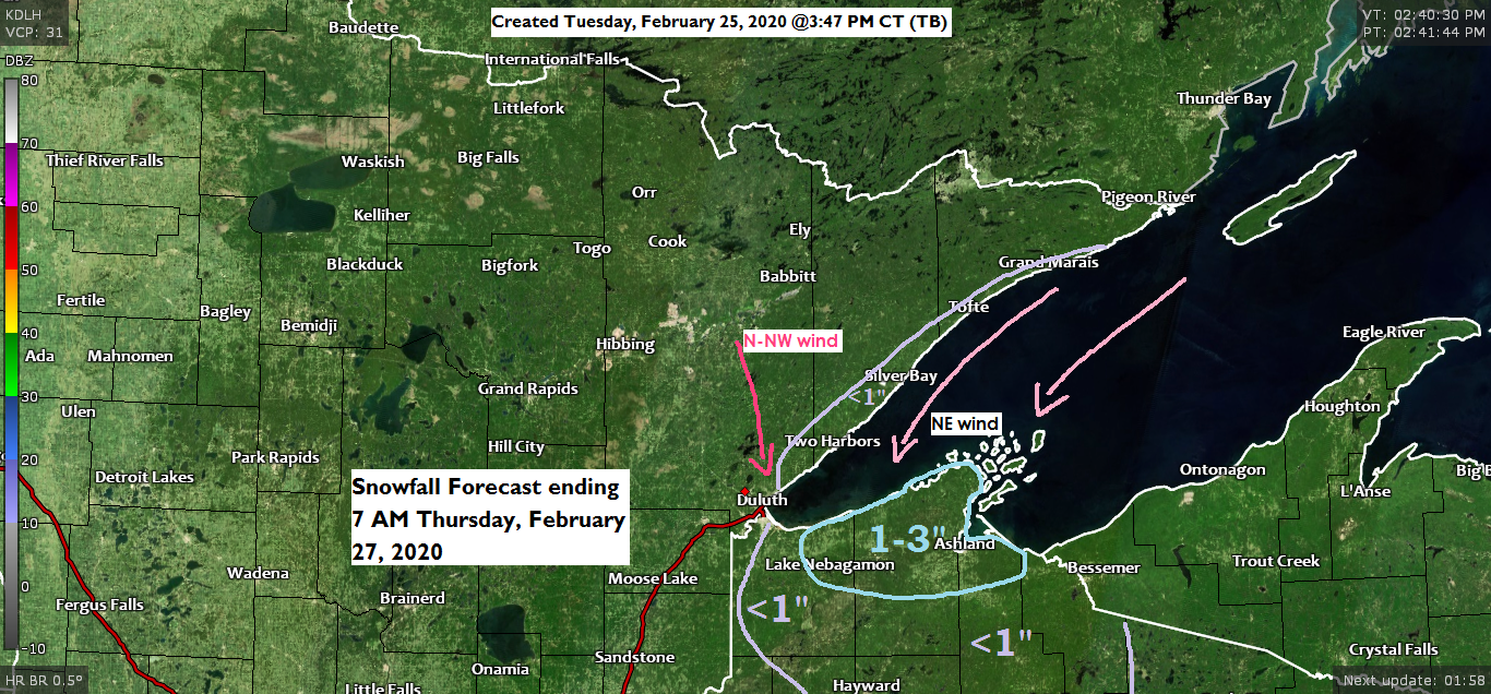
-Some snow is forecast to fall along the South Shore through Thursday morning, but most of it will fall on Wednesday. About 1 to 3 inches of snow is expected east of the Twin Ports, including the cities of Poplar, Iron River, Port Wing, Washburn, Bayfield and Ashland.
-Less than an inch of snow is forecast along the North Shore of Lake Superior, and across the rest of northwest Wisconsin, away from the South Shore.

Here’s the 18z NAM-WRF 3km model simulated radar forecast through 7 AM Thursday.
Snow shows up as blue colors on the map below.

The next few days will be on the chilly side. No more 40s or 50s this week.
Source: https://www.spc.noaa.gov/

Low temperature forecast for Wednesday morning, February 26th, 2020. Source: https://graphical.weather.gov/

High temperature forecast for Wednesday, February 26th, 2020.

…Weather Summary…
We saw some changes in the Northland today. More clouds compared to the last few days, and even some snow flurries in parts of the area today! Temperatures have also trended cooler with highs today generally in the upper 20s to lower 30s, which is still slightly above normal for late February.
Mostly cloudy to partly cloudy skies will be found across the Northland tonight and Wednesday with scattered flurries and light snow showers.
Heavier snow showers are possible late tonight into Wednesday along the South Shore of Lake Superior where the setup will become more favorable for lake effect snow as 850mb temperatures continue to drop into the -15 to -20C range. A convergence band may also setup for a time on Wednesday with NE winds over the lake, and a N-NW wind on land, if this develops, and lingers longer than expected, then we could see snowfall totals exceed 3″ in a few locations along the South Shore on Wednesday, but this chance is fairly low.
Lows tonight will range from the single digits below to teens above zero with highs Wednesday in the teens and 20s.
Temperatures remain on the chilly side Thursday and Friday with highs in the teens and 20s.
Forecast for Duluth and Superior
.Tonight… Partly to mostly cloudy. Snow showers and flurries. Low 10 to 15. Wind north to northwest 10 to 20 mph.
.Wednesday… Partly to mostly cloudy. Snow showers and flurries. High 17 to 22. Wind north to northwest 10 to 20 mph.
.Thursday… Partly to mostly cloudy. High 15 to 20. Wind northwest 10 to 15 mph.
| Normal temperatures for February 26 High 28 Low 10 Sunrise Wednesday 6:55 AM CST Sunset Wednesday 5:49 PM CST |
Thanks for reading!
Tim
Leave a Reply