A strong low pressure system is passing north of Minnesota today as it moves across Saskatchewan and into Ontario, but the southern portion of this system is clipping the extreme northern part of Minnesota where some light snow has been reported this afternoon in the Warroad and Baudette areas.
Source: https://www.star.nesdis.noaa.gov/

Nothing arctic, but a cooler air mass is spreading SE out of the Red River Valley this afternoon which is shoving the mild bubble of air farther off to the east late today.
Source: https://www.spc.noaa.gov/

Temperatures for Monday won’t be as mild as they were on Sunday across the Northland, but not cold either as daytime highs will still be running a few degrees above normal for early March.
Source: RTMA model; https://lab.weathermodels.com/

Mild temperatures are forecast in the Northland this week, and yes you can still get a little snow even in a mild pattern, new snow that falls this week won’t be sticking around for very long though.
Source: 12z European ensemble model 3.1.20; https://weathermodels.com/

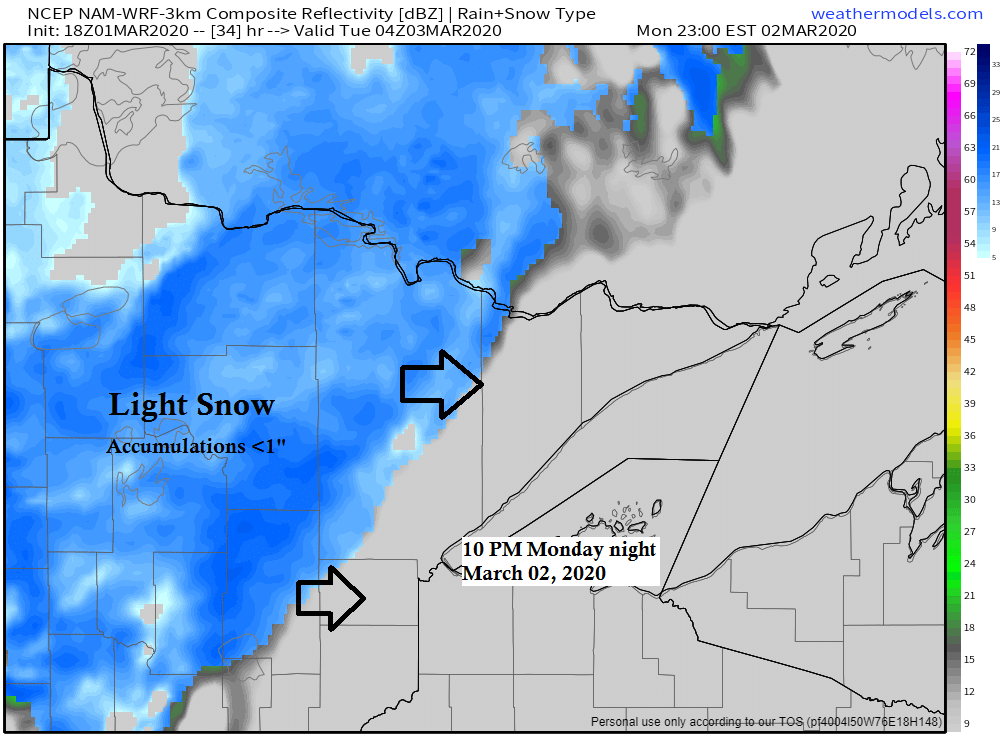
Look at this! There may actually be a little snow in the Northland Monday night-early Tuesday morning (blue colors on map) As for amounts, not much, maybe a half inch in spots.
Simulated radar forecast below is from 6 PM Monday to 6 AM Tuesday.
Source: 18z NAM-WRF model 3.1.20; https://weathermodels.com/

Computer models are in good agreement depicting a strong ridge moving over the Plains for next weekend (March 7-8) Could have widespread 60s and 70s for high temperatures from the Dakotas to the Central Plains while parts of Minnesota, most likely western/southern areas of the state could see their first 60s of the year either next Saturday or Sunday.
Source: 12z European model 3.1.20; https://home.pivotalweather.com/

Low temperature forecast for Monday morning, March 2nd, 2020. Source: https://lab.weathermodels.com/

High temperature forecast for Monday, March 2nd, 2020.

| Temperature and Precipitation report for Duluth, Minnesota for the week of February 23rd, 2020. High Temperatures/Departure from Normal 2.23: 43F/+16 degrees above normal 2.24: 39F/+12 degrees above normal 2.25: 32F/+5 degrees above normal 2.26: 23F/-5 degrees below normal 2.27: 19F/-9 degrees below normal 2.28: 22F/-6 degrees below normal 2.29: 30F/+1 degree above normal Low Temperatures/Departure from Normal 2.23: 22F/+13 degrees above normal 2.24: 20F/+11 degrees above normal 2.25: 17F/+7 degrees above normal 2.26: 10F/Normal 2.27: 1F/-10 degrees below normal 2.28: -3F/-14 degrees below normal 2.29: 6F/-5 degrees below normal Note: Average temperature in Duluth for the week of February 23rd: 20.1 degrees; +1.2 degrees above normal. Source: https://www.dnr.state.mn.us/ Total precipitation: Trace Normal: 0.23″ Departure: -0.23″ below normal State Average for Minnesota for the week of February 23rd, 2020. Temperature: 21.6 degrees Departure: +0.9 degrees above normal Precipitation: 0.00″ Departure: -0.19″ below normal |
Average temperature, departure from mean for the week of February 23rd, 2020. Source: https://mrcc.illinois.edu/

Total precipitation, departure from mean for the week of February 23rd, 2020.

Here are a few pics of this morning’s sunrise from Brighton Beach (Lake Superior) Sunday, March 1, 2020. Enjoy!


…Weather Summary…
The weather pattern will remain generally quiet in our area this week, but we will see a couple of systems pass north of us through Thursday. Each one of these systems could bring a brief round of light snow or a mixture of precipitation types to northeast Minnesota and northwest Wisconsin. Timing of these minor precipitation events appear to be in the Monday evening-early Tuesday time frame, and sometime in the Wednesday or Thursday time frame. No major accumulations of snow are expected at this time, but there may be just enough snow to cause some slick spots on the roads Monday night/early Tuesday, and possibly again with the midweek event.
So although temps will be mild this week, mother nature still reminds us that winter isn’t over quite yet, but again I don’t see any major winter storm hitting our area this week, just a nuisance snow event or two.
Lows tonight will be in the teens and 20s with highs Monday in the 30s.
High temperatures are forecast to be in the 30s to lower 40s for Tuesday and Wednesday.
Gusty west to northwest winds tonight will shift to the southwest Monday afternoon. Wind speeds of 10 to 20 mph with gusts of 25-35 mph.
Forecast for Duluth and Superior
.Tonight… Windy this evening. Partly to mostly cloudy. Low 20 to 25. Wind west to northwest 15 to 25 mph with gusts to 35 mph this evening.
.Monday… Breezy. Partly to mostly cloudy. High 30 to 35. Wind west 10 to 20 mph becoming southwest.
.Tuesday… A little snow possible early, otherwise partly to mostly cloudy. High 36 to 41. Wind west to southwest 10 to 20 mph.
| Normal temperatures for March 2 High 29 Low 11 Sunrise Monday 6:45 AM CST Sunset Monday 5:57 PM CST |
Thanks for reading!
Tim
Leave a Reply