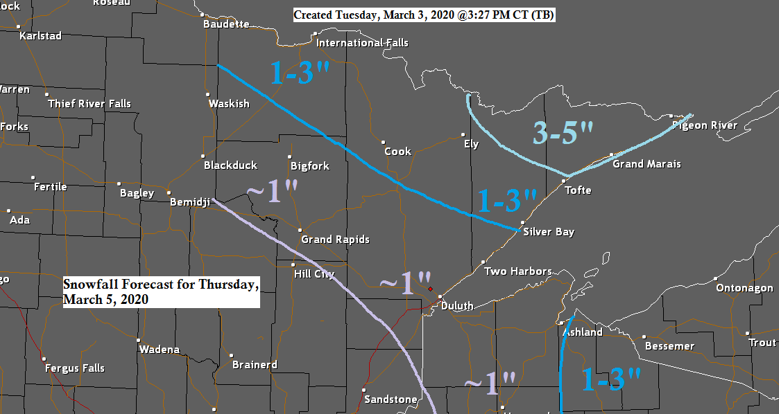
A stronger clipper system is forecast to affect the Northland late Wednesday night into Thursday with some snow and mixed precipitation.
Greatest snow amounts are forecast to be in the tip of the Arrowhead (3-5″) lesser amounts of snow further southwest (~1 or less)
Looks like will get around an inch or less of snow in Duluth and Superior late Wednesday night and Thursday.

Our system which affects the Northland on Thursday is just moving into British Columbia today per Goes-16 water vapor imagery.
Source: https://www.star.nesdis.noaa.gov/

Forecast track of our next clipper.
Typically with these systems, most of the snow tends to fall north of the low pressure track (black line on map)
Source: https://www.wpc.ncep.noaa.gov/

Could see a little icing develop near Lake Superior late Sunday into Monday as colder temperatures move in near the surface while aloft a layer of warm above freezing air will be in place, this coupled with some moisture on northeast winds may lead to areas of freezing rain and freezing drizzle near Lake Superior late Sunday into Monday. Note: At the moment this doesn’t look like it will be a significant ice event with mostly trace amounts of ice accumulation, however, a few computer models like the UK and Canadian are showing greater amounts of ice and snow potential across parts of the Northland Sunday night and Monday. The European model had also shown a more impactful system affecting the area Sunday night and Monday, but they have since backed off on that solution over the last few model runs.
Stay tuned
Source: 12z European computer model 3.3.20; https://www.tropicaltidbits.com/

Here’s the forecast map for Sunday, March 08 – Doubtful will get two mild days in a row in Duluth this weekend given the forecast setup for Sunday which shows a cold front slipping south of us while a strong high approaches from Manitoba. Winds shift northeast and increase to 15 to 30 mph right off Lake Superior, so right now Saturday looks like the warmer day of the weekend in Duluth as Sunday features a gusty lake wind and colder temperatures.
Source: https://www.wpc.ncep.noaa.gov/

Low temperature forecast for Wednesday morning, March 4th, 2020. Source: https://lab.weathermodels.com/

High temperature forecast for Wednesday, March 4th, 2020.

An outbreak of severe thunderstorms including 7 preliminary tornado reports occurred across portions of the Southern Mississippi Valley Monday night into early Tuesday morning.
The Nashville, Tennessee area was hit by a strong tornado early Tuesday morning, March 3rd, 2020.
Reports of at least 22 deaths in central Tennessee due to the severe weather Monday night-early Tuesday morning.
SPC storm reports map below
Red=Tornado
Green=Large Hail 1″+ diameter
Blue=Wind reports 58 mph or stronger

…Weather Summary…
Generally quiet weather tonight and during the day Wednesday, but a few snow or mixed showers will continue this evening in parts of east-central Minnesota and northwest Wisconsin.
Lows tonight will be in the single digits and teens, but a few locations in northern Minnesota could have lows a few degrees below zero.
Highs on Wednesday will be in the 30s.
Northwest to west winds tonight at 10 to 20 mph becoming south to southwest Wednesday.
Some snow or mixed rain, sleet and snow will be possible over northeast Minnesota and northwest Wisconsin Wednesday night and Thursday as low pressure tracks SE into the upper Great Lakes region. Note: Steep mid level lapse rates of around 7.0-8.5 c/km and even some weak instability will accompany this system, so its possible will see convective type snow/sleet showers in parts of the Northland late Wednesday night and Thursday.
Warmer weather returns on Saturday as a large ridge builds over the Plains and upper Midwest. Highs across the Northland on Saturday are forecast to be in the 40s with a few 50s also possible. Note: It still looks like parts of western and southern Minnesota will see their first 60s of the year either on Saturday or Sunday.
Forecast for Duluth and Superior
.Tonight… Breezy this evening. Partly to mostly cloudy. Low 14 to 19. Wind west to northwest 5 to 15 mph with gusts to 25 mph this evening.
.Wednesday… Partly cloudy. High 33 to 38. Wind west to southwest 10 to 20 mph.
.Thursday… Some light snow or mixed precipitation possible at times. Snowfall accumulations less than an inch. Mostly cloudy. High 34 to 39. Wind south, becoming west 15 to 20 mph.
| Normal temperatures for March 4 High 30 Low 13 Sunrise Wednesday 6:42 AM CST Sunset Wednesday 6:00 PM CST |
Thanks for reading!
Tim
Leave a Reply