A nice temperature gradient is in place for Thursday’s clipper with cold air up north, warm air to the south.
Potential for 3 inches or more of snow in the blue outlined area on map late tonight into Thursday.
Source: https://www.spc.noaa.gov/

Here’s my updated snowfall forecast for late tonight through Thursday evening.
*Highest amounts of 5 to 7 inches in the tip of the Arrowhead including Tofte, Grand Marais and Hovland.
*An area of 3 to 5 inches of snow including International Falls, Cook, Ely and Isabella.
*2 to 3 inches of snow including Bigfork, Hibbing and Silver Bay.
*Lesser amounts of snow further south with amounts of 1 to 2 inches including Grand Rapids, Two Harbors, Twin Ports, Bayfield, Solon Springs and Hayward.
Note: The 3 to 5 inch zone in northwest Wisconsin is mainly for the late Thursday afternoon/Thursday night time frame when some lake effect snow is expected to develop.
*Travel impacts in the 1 to 2 inch zone probably won’t be too significant as snow that falls may melt on contact as it hits road surfaces, plus this appears to be more of a showery type snowfall, meaning it could snow heavily for a brief time, with no snow falling for hours in between the showers.
*I think the greatest impacts to travel will be in the 3 to 5 inch, and 5 to 7 inch zones, so mostly across far northern Minnesota and in the tip of the Minnesota Arrowhead where I’m expecting snow/slush covered roads on Thursday.

Winter Weather Advisory has been issued for far northeast Minnesota (purple area on map) from 9 PM this evening to Noon Thursday. Note: It’s possible we may see the advisory expand a bit to the west depending on how things evolve overnight into Thursday morning.
-Snow covered and slippery roads and reduced visibilities are likely in the advisory area later tonight into Thursday.
-Breezy east winds 10 to 20 mph with gusts to 30 mph Thursday, becoming north. Patchy blowing snow is possible on Thursday in the advisory area.

A potent clipper system is making its way through the Northern Plains this afternoon and will move across the Northland late tonight into Thursday.
Source: Goes-16 low level water vapor imagery, March 4, 2020. https://www.star.nesdis.noaa.gov/

There is some instability with this clipper over North Dakota this afternoon with 100-500 j/kg of elevated CAPE along with steep mid level lapse rates on the order of 7.0-8.5 c/km per SPC meso-analysis page.
The cloud appearance on visible satellite imagery over western North Dakota also indicates this is a convective type setup as bands of locally heavy showers move off to the east.
Source: https://weather.cod.edu/

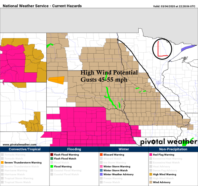
We’ve seen a few severe thunderstorm warnings pop up this afternoon in parts of the western Dakotas all associated with the clipper which is moving into the Northland tonight. A report of a 76 mph wind gust just before 3 PM today near Dickinson, North Dakota.
Note: No severe weather in the Northland tonight, but it’s an indication this system is fairly potent when it’s generating a few severe thunderstorms today.

Strong winds often occur with clipper systems, especially on the SW side of the low pressure track, so the potential for strong winds on Thursday is greatest in west-central and south-central areas of Minnesota and over parts of the Dakotas as low pressure moves SE across northern Minnesota.
Source: https://www.pivotalweather.com/
Low temperature forecast for Thursday morning, March 5th, 2020. Source: https://lab.weathermodels.com/

High temperature forecast for Thursday, March 5th, 2020.

…Weather Summary…
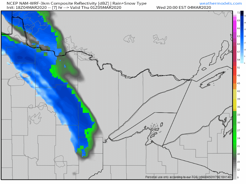
A little more active late tonight and Thursday thanks to a low pressure system which moves SE into northern Minnesota Thursday morning. This system will bring accumulating snow and some mixed precipitation to northeast Minnesota and northwest Wisconsin later this evening through Thursday. Note: Greatest snow totals are expected to remain north of Duluth and Superior tonight and Thursday.
Precipitation may take on a more showery nature across east-central Minnesota and northwest Wisconsin, meaning there will probably be some dry hours mixed in between the bands of precipitation tonight and Thursday.
Steep mid level lapse rates coupled with some weak elevated CAPE will lead to some convective bursts of snow or sleet, and when these hit they could be quite heavy, but they shouldn’t last very long. Timing of this would be from late tonight into Thursday afternoon.
Lows tonight will be in the 20s to lower 30s. Highs on Thursday ranging from the middle 20s to middle 30s, with upper 30s possible in parts of northwest Wisconsin.
Dry weather returns Friday with highs in the 30s.
Warmer weather this weekend with highs Saturday in the 40s and 50s. Still some uncertainty in temperatures on Sunday thanks to a cold front and where it decides to stall out. If the front remains off to the north, then Sunday will be another mild day with highs in the 40s and 50s, but if it moves south of our area, then it will be quite a bit cooler, especially near Lake Superior and in far northern Minnesota. Eventually the colder air wins out, but for only a brief time the way it looks now.
Forecast for Duluth and Superior
.Tonight… Mostly cloudy. A few snow or mixed snow, sleet and freezing rain showers possible late. Low 27 to 30. Wind south to southeast 5 to 15 mph.
.Thursday… Occasional wet snow. Some sleet or drizzle also possible. Heavier snow showers possible. High 33 to 37. Wind west 5 to 15 mph becoming north 10 to 20 mph. Total snowfall accumulations of 1 to 2 inches possible.
.Friday… Mostly sunny. High 31 to 36. Wind north becoming southeast 5 to 15 mph.
| Normal temperatures for March 5 High 30 Low 13 Sunrise Thursday 6:40 AM CST Sunset Thursday 6:01 PM CST |
Thanks for reading!
Tim
Leave a Reply