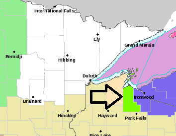
-Lakeshore Flood Advisory in effect until Midnight tonight for the South Shore of Lake Superior including Ashland and Iron Counties in northwest Wisconsin (light green area on map) Waves of 9 to 12 feet will cause lakeshore flooding from Saxon Harbor to the Mouth of the Bad River to Chequamegon Bay. Lakeshore flooding is also possible in Ashland, but ice cover over Chequamegon Bay should limit wave heights in that area.
-Winter Weather Advisory in effect until 6 AM CST Friday for Iron County in northwest Wisconsin (purple area on map) Snow and blowing snow with accumulations of 3 to 5 inches. Winds gusting to 40 mph. Plan on slippery road conditions and poor visibilities due to the snow and blowing snow.
Source: https://www.weather.gov/dlh/

| Snowfall Reports from around the Northland for March 4-5, 2020 Source: https://www.weather.gov/dlh/ 4 W Grand Marais, MN: 6.9″ 14 W Isabella, MN: 5.0″ International Falls, MN: 4.6″ 7 WSW Hovland, MN: 4.5″ 1 SSW Ely, MN: 4.5″ 1 E Silver Bay, MN: 3.2″ Winton, MN: 3.1″ 2 SSE Winter, WI: 3.0″ Duluth Airport: 2.2″ Kettle River, MN: 0.5″ Note: Record Snowfall in International Falls for March 5th with 3.6″ of snow today. Previous snowiest March 5th was 3.0″ set in 2013. |
I’m quite happy with my snowfall forecast for today’s event based on the reports I’ve seen thus far – This was my updated snowfall forecast I made on Wednesday for today’s event.
Pretty good in the 3-5″ and 5-7″ zones, some hits and misses elsewhere.
Near Grand Marais 6.9″ storm total (forecast was 5-7″)
I’Falls 4.6″ storm total (forecast was 3-5″)
Ely 4.5″ storm total (forecast was 3-5″)
Silver Bay 3.2″ storm total (forecast 2-3″)
Duluth 2.2″ storm total (forecast was 1-2″)
Kettle River 0.5″ storm total (forecast ~1″)

Here’s a look at the system which affected the Northland today per Goes-16 water vapor imagery.
A wound up clipper that’s for sure! This system dropped anywhere from a trace to as much as 7 inches of snow in the Northland today.
Source: https://www.star.nesdis.noaa.gov/

A chilly air mass will be over the Northland tonight, but will begin to modify a bit Friday with a much warmer air mass moving in on Saturday.
Source: https://www.spc.noaa.gov/

Still looking at a large upper level ridge building over the Plains and upper Midwest this weekend leading to widespread warmth Saturday and Sunday.
High temperatures in northeast Minnesota and northwest Wisconsin are forecast to range from the middle 40s to middle 50s on Saturday with a southwest wind. Record warmth is unlikely in our area Saturday, but a top 5 warmest high temperature for March 7th is a possibility – See record highs list below.
Record High Temperatures for March 7th
Ashland, WI: 75 F set in 1987
Brainerd, MN: 71 F set in 2000
Hibbing, MN: 70 F set in 2000
Duluth, MN: 70 F set in 2000
International Falls, MN: 67 F set in 2000
Source: 12z European model 3.5.20; https://www.pivotalweather.com/

Sunday’s temperature forecast hinges on where a cold front in far northern Minnesota (blue line on map) ends up. If it stays up north, then another mild day is likely on Sunday, but if the front drops south, then it will be turning colder on Sunday with a breezy NE wind near Lake Superior.
Note: Right now it looks like Sunday may start out on the warm side in the Twin Ports, then turning colder as a lake wind develops in the afternoon.
Source: https://www.wpc.ncep.noaa.gov/

Low temperature forecast for Friday morning, March 6th, 2020. Source: https://lab.weathermodels.com/

High temperature forecast for Friday, March 6th, 2020.

Beginning to see some signs that the weather pattern could become a bit more active in our area toward the middle of the month with precipitation totals near to above average through March 20th.
Source: 12z European ensemble model 3.5.20; https://weathermodels.com/

…Weather Summary…
Chilly tonight with lingering snow and areas of blowing snow along the South Shore with flurries in eastern Minnesota. Some clearing is likely later tonight from NW to SE. Lows will range from the single digits below to teens above zero with a few teens below possible in far northern Minnesota. Winds will be out of the north to northwest at 10 to 20 mph with gusts of 25 to 40 mph especially this evening.
A nicer day on Friday with mostly sunny skies. Highs in the upper 20s to upper 30s with north or south winds 10 to 15 mph.
Dry and warmer Saturday. Highs in the 40s and 50s with south to southwest winds 15 to 25 mph.
Note: Will see quite a change in 850mb temperatures over the next few days as they start out around -8C Friday morning, warming to around +8 to +12C Saturday evening.
The setup late Sunday into Monday could become favorable for the development of freezing drizzle and light snow in parts of the Northland. This doesn’t look like it would be a major event with just trace amounts of ice or snow expected at this time. Stay tuned.
Forecast for Duluth and Superior
.Tonight… Breezy. Decreasing cloudiness. Low 6 to 11. Wind north to northwest 15 to 30 mph, decreasing to 10 to 20 mph late.
.Friday… Mostly sunny. High 29 to 34. Wind north 5 to 15 mph becoming southeast.
.Saturday… Breezy and warmer. Mostly sunny. High 47 to 52. Wind southwest 15 to 25 mph.
| Normal temperatures for March 6 High 30 Low 14 Sunrise Friday 6:38 AM CST Sunset Friday 6:02 PM CST |
Thanks for reading!
Tim
Leave a Reply