Is this March or June? Temperatures will soar into the 40s and 50s across the Northland this weekend. Don’t forget the sunscreen! Duluth has a good chance at seeing its 1st 50 of the year this weekend. Note: Average date for 1st 50 degree high in Duluth is March 20th (1875-2019 climate period) Earliest 1st 50 on record in Duluth was on January 14th, 1894.
Here comes the warmth! Warmest air mass so far this year will move into the upper Midwest this weekend with 850mb temperatures climbing to around +8 to +16C!
Source: https://www.spc.noaa.gov/

Upper level ridge over the Rockies and Plains builds into the upper Midwest this weekend.
Source: https://www.spc.noaa.gov/

A large upper level ridge will cover the Plains and upper Midwest this weekend which will lead to high temperatures running a good 15 to 30 degrees above normal for early March.
Source: https://lab.weathermodels.com/

Low temperature forecast for Saturday morning, March 7th, 2020. Source: https://lab.weathermodels.com/

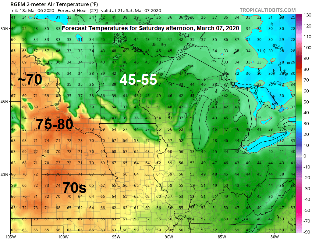
High temperature forecast for Saturday, March 7th, 2020.

Looks like we may see some changes in the upper level pattern as we head into mid-March, this could increase the probabilities that a couple of storm systems affect the Northland with chances for rain or snow. Something to keep an eye on from ~March 15th and beyond.
Source: 12z European ensemble model 3.6.20; https://weathermodels.com/

Euro ensemble (EPS) model 50 member snowfall matrix for Duluth through March 21st, 2020 – Certainly seeing a trend toward a potentially snowier pattern setting up around mid-month noted by the chiclets turning more colorful on the graph below.

Weather Tidbits for Duluth, Minnesota
-Precipitation total of 0.22″ on March 5th was the greatest calendar day precipitation total since January 23rd (0.23″)
-Snowfall of 2.2″ on March 5th was the first 1″ or greater snowfall total since February 17th..
-Snowfall of 2.2″ on March 5th was the greatest calendar day snowfall total since February 7th (2.9″)
…Weather Summary…
If you like sunshine and warm early spring temperatures this weekend is for you!
Clear to partly cloudy skies tonight and Saturday.
Lows tonight in the teens and 20s. Highs Saturday in the 40s and 50s. Winds out of the south 5 to 15 mph with gusts of 20 to around 30 mph on Saturday.
A cold front begins to move south out of Ontario Saturday night, but this boundary may stall out over northern Minnesota on Sunday, before it moves further south/east Sunday night. Where this front sets up on Sunday will determine how warm it gets in our area on Sunday. Looks like will have highs in the 40s and 50s in east-central Minnesota and northwest Wisconsin, but there is a chance that a few locations will climb into the 60s, while cooler 30s will be found in far northern Minnesota and along the North Shore of Lake Superior where clouds, patchy fog and drizzle is possible on Sunday.
A colder air mass will then overspread the entire Northland Sunday night and Monday with a chance for some freezing drizzle and light snow showers.
Forecast for Duluth and Superior
.Tonight… Mostly clear. Low 20 to 25. Wind east to southeast around 10 mph.
.Saturday… Breezy and warmer. Mostly sunny. High 47 to 52. Wind south to southwest 15 to 25 mph. Note: Record high for March 7th is 70 degrees set in 2000.
.Sunday… Partly to mostly cloudy. High 45 to 50 but turning cooler near Lake Superior. Wind variable becoming northeast 10 to 20 mph.
| Normal temperatures for March 7 High 31 Low 14 Sunrise Saturday 6:36 AM CST Sunset Saturday 6:04 PM CST |
Thanks for reading!
Tim
Leave a Reply