Not a whole lot of precipitation in the Northland through early next week with mostly very light precipitation events, if anything happens at all. Split flow continues, storms north, south, east and west.
Source: https://lab.weathermodels.com/

A cooler (more seasonable) air mass covered the Northland today with high temperatures in the upper 20s to middle 30s.
Source: https://www.spc.noaa.gov/

I’m still not seeing much consistency in the computer models which would support a wetter/stormier pattern in northeast Minnesota and northwest Wisconsin through the next 2 weeks. Sure there’s been an occasional model run the last few days which have shown a stormy pattern developing across the upper Midwest after March 15th, but the trends yesterday and again today seem to want to keep most of the bigger storms south/east of our area looking out the next 2 weeks, so basically just a continuation of the pattern that has been in place since December.
Source: 12z European ensemble model 3.9.20; https://weathermodels.com/

Low temperature forecast for Tuesday morning, March 10th, 2020. Source: https://lab.weathermodels.com/

High temperature forecast for Tuesday, March 10th, 2020.

Weather Tidbits
-Temperature hit 51 degrees in Duluth on Sunday, March 8th, this was the 1st 50 degree or warmer temperature in Duluth since October 26, 2019, high on that date was 60 degrees. Note: Last year’s 1st 50 in Duluth occurred on March 21st.
-Average date for 1st 50 in Duluth is March 20th so this year’s 1st 50 came about 2 weeks ahead of schedule, while last year’s 1st 50 occurred just 1 day later than average.
-So we got our 1st 50 degree temperature for the year out of the way on Sunday, now when do we typically see our first 60 degree temperature in Duluth? On average, April 12th is when we typically see our 1st 60 degree temperature in Duluth (1875-2019 climate period) Note: Earliest 1st 60 on record in Duluth was on March 6th, 1987; latest 1st 60 in Duluth was on May 11th, 1950.
Temperature and Precipitation report for Duluth, Minnesota from March 1 to March 7, 2020.
| High Temperatures/Departure from Normal 3.1: 42F/+13 degrees above normal 3.2: 36F/+7 degrees above normal 3.3: 36F/+7 degrees above normal 3.4: 36F/+6 degrees above normal 3.5: 32F/+2 degrees above normal 3.6: 29F/-1 degree below normal 3.7: 46F/+15 degrees above normal Low Temperatures/Departure from Normal 3.1: 22F/+11 degrees above normal 3.2: 25F/+13 degrees above normal 3.3: 24F/+12 degrees above normal 3.4: 14F/+1 degree above normal 3.5: 17F/+4 degrees above normal 3.6: 3F/-11 degrees below normal 3.7: 25F/+11 degrees above normal Note: Average temperature in Duluth for the week of March 1st, 2020: 27.6 degrees; +6.5 degrees above average. Source: https://www.dnr.state.mn.us/ Total precipitation: 0.23″ Normal: 0.30″ Departure: -0.07″ below average State Average for Minnesota for the week of March 1st, 2020. Temperature: 29.6 degrees Departure: +6.2 degrees above average Precipitation: 0.05″ Departure: -0.22″ below average |
Average temperature, departure from mean for the week of March 1st, 2020. Source: https://mrcc.illinois.edu/

Total precipitation, departure from mean for the week of March 1st, 2020.

…Weather Summary…
Clear to partly cloudy tonight. Chilly with lows in the single digits and teens. Winds north to northwest 5 to 15 mph.
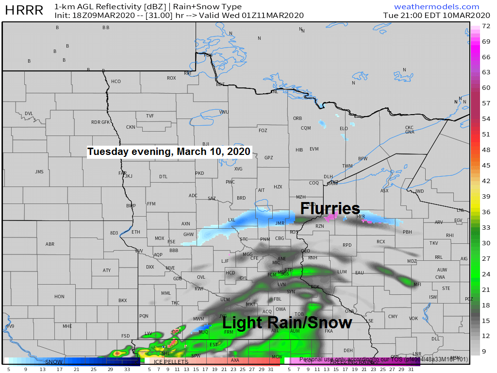
Dry Tuesday with highs in the 30s. Winds becoming southwest 10 to 15 mph. Will likely have quite a bit of sunshine in the morning, but then some increase in clouds in the afternoon as a low pressure disturbance moves E-NE out of the Western High Plains, most of the precipitation (Rain & Snow) associated with this feature should stay south of the Northland, but a little light snow and flurries could clip east-central Minnesota and northwest Wisconsin Tuesday night.
Another round of mostly light rain or snow showers comes late Wednesday into Thursday, but amounts look very light. Highs in the 30s to lower 40s Wednesday and Thursday.
Forecast for Duluth and Superior
.Tonight… Mostly clear. Low 10 to 15. Wind north to northwest 5 to 15 mph.
.Tuesday… Mostly sunny with some increase in clouds possible in the afternoon. High 33 to 37. Wind becoming southwest 10 to 15 mph.
.Wednesday… Partly to mostly cloudy. High 33 to 37. Wind south 10 to 15 mph.
| Normal temperatures for March 10 High 32 Low 15 Sunrise Tuesday 7:30 AM CDT Sunset Tuesday 7:08 PM CDT |
Thanks for reading!
Tim
Leave a Reply