-Winter Storm Warning remains in effect until 1 PM Monday including the cities of Washburn, Bayfield, Ashland, Hurley and Gile.
-Winter Storm Warning remains in effect until 7 AM Monday including the cities of Minong, Spooner, Shell Lake, Hayward and Winter.
-Winter Weather Advisory (purple area on map) remains in effect until 4 AM Monday including the cities of Lake Nebagamon, Solon Springs, Webster, Siren and Grantsburg.
-Snow, heavy at times will continue tonight across all but far northwest Wisconsin. Snow will taper off on Monday, but could continue through the day along the South Shore of Lake Superior.
-Gusty north winds 20 to 35 mph will cause areas of blowing and drifting snow.
-Travel could be very difficult to impossible tonight and Monday morning, especially in the winter storm warning area.
-Expect snow covered and slippery roads, and very poor visibility due to the snow and blowing snow.
Source: https://www.weather.gov/dlh/

Road Conditions
Minnesota https://lb.511mn.org/
Wisconsin https://511wi.gov/
Here’s my updated snowfall forecast ending Noon Monday
*5 to 9 inches of snow (locally higher amounts) including Winter, Butternut, Glidden and Park Falls.
*An area of 9″+ totals in the Hurley and Gile areas.
*3 to 5 inch totals including Bayfield, Ashland, Hayward and Shell Lake.
*1 to 3 inch totals including Grand Marais, Lake Nebagamon, Solon Springs, webster and Siren.
*Little to no snow in Duluth, Superior, Two Harbors and Silver Bay.

Snow continues tonight in most of northwest Wisconsin while some snow gradually spreads into the tip of the Arrowhead of Minnesota later tonight. Snow tapers off from W-E on Monday.
Simulated radar forecast valid from 7 PM this evening to 7 PM Monday.
Source: 18z NAM-WRF model 4.12.2020; https://weathermodels.com/

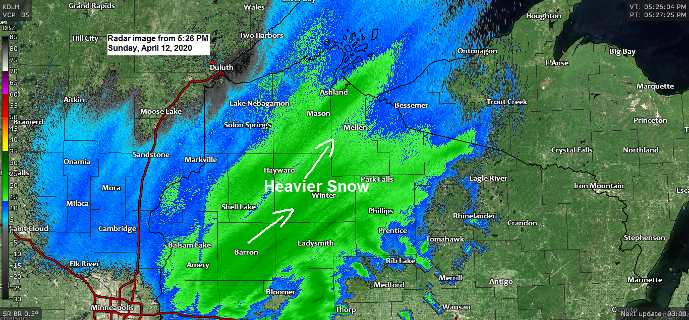
On the cold side of this powerful storm is the snow, and it’s been falling at a good clip this afternoon from south-central Minnesota into west-central and north-central Wisconsin with snowfall rates of 1 to nearly 2 inches an hour being reported.
Source: https://www.spc.noaa.gov/

A powerful April storm is moving NE out out of the Southern Plains today. This storm has been producing heavy snow and strong winds in portions of the Western High Plains into parts of the upper Midwest today, while in the warm sector of this storm, severe thunderstorms and tornadoes have been occurring today over parts of the Ark-La-Miss region.
Source: Goes-16 water vapor imagery 4.12.2020; https://weather.cod.edu/

A potent severe weather setup is in place through tonight over parts of the southeast US.
-Strong winds aloft
-Strong low level jet, and wind shear
-Forcing due to the surface low, mid-upper level trough/low, various boundaries, warm front and cold front

Moderate and enhanced risk for severe thunderstorms continues through tonight in the red and orange areas, a slight risk in yellow.
Source: SPC; https://www.pivotalweather.com/

4 tornado watches (red outlined areas) in effect through late tonight. 2/4 watches are PDS or a Particularly Dangerous Situation!
Source: https://www.spc.noaa.gov/

On Monday the risk for severe weather pushes farther east into the Mid-Atlantic and Carolinas. Tornadoes are possible once again on Monday from Virginia, south through the Carolinas.

Temperature and Precipitation report for Duluth, Minnesota for April 5 to April 11, 2020.
| High Temperatures/Departure from Normal 4.5: 46 F/+2 degrees above normal 4.6: 50 F/+6 degrees above normal 4.7: 62 F/+17 degrees above normal 4.8: 50 F/+5 degrees above normal 4.9: 35 F/-11 degrees below normal 4.10: 46 F/Normal 4.11: 52 F/+5 degrees above normal Low Temperatures/Departure from Normal 4.5: 24 F/-2 degrees below normal 4.6: 33 F/+7 degrees above normal 4.7: 37 F/+11 degrees above normal 4.8: 30 F/+3 degrees above normal 4.9: 27 F/Normal 4.10: 23 F/-5 degrees below normal 4.11: 30 F/+2 degrees above normal Note: Average temperature in Duluth for the week of April 5, 2020: 38.9 degrees; +2.9 degrees above average. Source: https://www.dnr.state.mn.us/ Total Precipitation: 0.24″ Normal: 0.49″ Departure: -0.25″ below average State Average for Minnesota for the week of April 5, 2020 Temperature: 39.9 degrees Departure: 0.0 degrees Precipitation: 0.16″ Departure: -0.38″ below average |
Average temperature, departure from mean for the week of April 5, 2020. Source: https://mrcc.illinois.edu/

Total precipitation, departure from mean for the week of April 5, 2020.

…Weather Summary – A look ahead to Monday and Tuesday’s weather…
Cold temperatures will stick around the next few days with highs Monday in the 20s and 30s, highs Tuesday in the 20s to lower 30s. Lows tonight and Monday night will be in the teens and 20s.
Blustery northwest winds tonight and Monday at 10 to 20 mph with gusts >25 mph.
Mostly cloudy to partly cloudy skies will be found across the Northland through Tuesday with a chance for a few snow showers and flurries Monday and Tuesday.
Thanks for reading!
Tim
Leave a Reply