Lake effect snow showers on May 4th? Yes, radar was showing some lake effect snow early Monday morning along the North Shore of Lake Superior, roughly from Two Harbors to Silver Bay. Spring 2020!

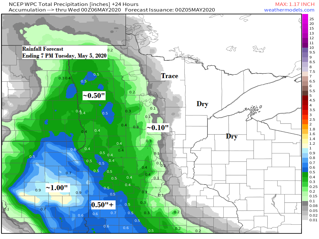
-Only far western portions of the Northland may see some rain on Tuesday, say from around International Falls to Brainerd and west from there. The rest of the Northland should remain dry on Tuesday under mostly cloudy/partly sunny skies. Highs Tuesday are forecast to be in the 40s and 50s with southerly or easterly winds at 5 to 15 mph.
Simulated radar forecast valid from 7 AM to 7 PM Tuesday, May 5th, 2020.
Source: 18z NAM-WRF model 5.4.2020; https://weathermodels.com/

Low pressure over the Northern Plains will head SE through Tuesday. Most of the rain associated with this system will pass west/south of the Northland.
Source: Goes-16 lower level water vapor imagery 5.4.2020; https://weather.cod.edu/

Radar loop ending at 5:35 PM CT, Monday, May 4, 2020.

A very cold air mass for May is still on track for late this week as a very strong upper level low heads S-SE out of Hudson Bay and Ontario.
Temperatures at ~18,000 feet (500mb) are forecast to be around -40C near the center of this low on Friday, that’s pretty ridiculous for May.
The Northland will be on the western side of this upper low with the coldest air likely to pass east of our area, but it will still be chilly around here later this week, record setting cold? Will have to wait and see.
Could see some lake effect snow along the South Shore of Lake Superior in northern Wisconsin and Upper Michigan on Friday, and possibly a few flurries in northeast Minnesota due to the amount of cold air over the area.
Source: 12z European model 5.4.2020; https://www.pivotalweather.com/

Here’s the temperature anomaly forecast for May 7 to May 12 – Looks chilly!
Note: The 2020 fishing opener in Minnesota and here in northeast Minnesota looks dry but cool. Temperatures in the 20s early Saturday morning, climbing into the 40s to around 50 degrees Saturday afternoon. Winds out of the N-NW at 10 to 15 mph.
Source: 12z European model 5.4.2020; https://lab.weathermodels.com/

Spring 2020 across the Northland is running warmer and drier than spring 2019, through May 3rd – See stats below.
Source: https://www.dnr.state.mn.us/
Duluth, Minnesota
+1.3 degrees warmer; -0.45″ drier than last spring.
International Falls, Minnesota
+1.3 degrees warmer; -1.29″ drier than last spring.
Brainerd, Minnesota
+4.5 degrees warmer; -1.59″ drier than last spring.
Here’s a look at the percent of precipitation that has fallen so far this spring (thru May 3rd)
*Cities such as International Falls, Bigfork, Walker, Grand Rapids and Brainerd have seen between 25-50% of its normal precipitation so far this spring.
*Grand Marais, Duluth, Hinckley, Solon Springs and Siren have seen about 75% of its normal precipitation so far this spring, while Ashland, Hayward and Hurley have seen just about their normal precipitation values so far for spring 2020.
*To sum it up, this spring has been drier than normal across western portions of the Northland, while most of northwest Wisconsin has had near normal precipitation so far this spring.
Source: https://mrcc.illinois.edu/

Source: https://mrcc.illinois.edu/


Forecast for Duluth and Superior
.Tonight… Breezy. Partly to mostly cloudy. Low 30 to 35. Wind east 10 to 20 mph with higher gusts.
.Tuesday… Mostly cloudy. High 45 to 50 but cooler near Lake Superior. Wind east 10 to 15 mph.
.Wednesday… Partly sunny. High 53 to 58 but turning cooler near Lake Superior. Wind northwest 5 to 15 mph becoming northeast.
| Normal temperatures for May 5 High 59 Low 38 Sunrise Tuesday 5:47 AM CDT Sunset Tuesday 8:25 PM CDT |
Thanks for reading!
Tim
Leave a Reply