-Today (Wednesday) was likely the last time we see 60 degree temperatures in Duluth until maybe late next week at the earliest, and 60s are right where we should be this time of the year.
-Cooling trend begins Thursday with highs across the Northland in the 40s and 50s. Winds will be out of the north at 10 to 20 mph with stronger gusts likely.
-There is a chance we could see a few flurries or snow showers Friday morning in far northeast Minnesota, and also along the South Shore of Lake Superior where some lake effect snow showers are possible on Friday, mainly impacting areas from near Ashland and Butternut, east to Hurley and Gile.
-Fishing Opener on Saturday in northeast Minnesota continues to look cool, but dry. Early morning temps in the 20s, afternoon temps in the 40s to lower 50s. Winds northwest 5 to 15 mph with gusts to around 20 mph.
Note: Near-Critical Fire Weather Conditions are expected across the Northland for Thursday and Friday due to a combination of dry fuels, low relative humidity ranging from 15 to 25 percent, and gusty winds of 20 to 30 mph. Any fires that start could spread very rapidly the next few days. Avoid burning the next few days.
Fire danger through this evening is rated as very high to high in parts of northeast Minnesota (orange and yellow colors on map) Similar fire danger ratings are likely for Thursday and Friday.
Source: https://www.dnr.state.mn.us/


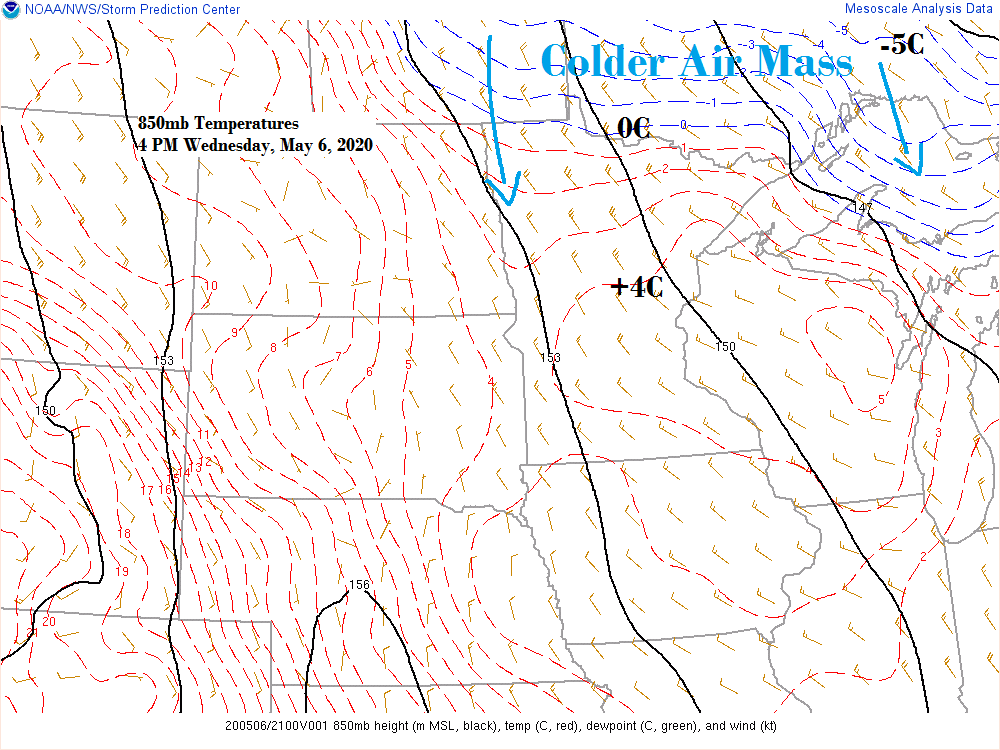
We’re heading into a cooler stretch of weather over the next several days. There is a chance for record or near record cold across the Northland on a few dates between May 8th-12th.
Source: 12z European ensemble model 5.5.2020; https://weathermodels.com/

Looking ahead to late next week shows some signs that the pattern may be starting to change as the greatest departures from normal lift north into Canada which leaves the Northland in near normal/seasonable temperatures for mid-May.
Source: 12z European ensemble model 5.6.2020

On today’s date, May 6th (2016) the temperature reached 92 degrees in Duluth, Minnesota making it the earliest date for a 90 degree or warmer temperature on record in the city. The previous earliest was May 14th (1932) Here’s a look at what the upper level maps looked like back on May 6th, 2016.


Forecast for Duluth and Superior
.Tonight… Partly cloudy. Low 31 to 36. Wind northwest 5 to 15 mph but east winds near Lake Superior becoming northwest.
.Thursday… Breezy. Partly to mostly sunny. Cooler. High 49 to 53. Wind north 10 to 20 mph.
.Friday… Breezy. Partly cloudy. High 39 to 44. Wind north 10 to 20 mph.
| Normal temperatures for May 7 High 60 Low 38 Records for May 7 High: 88 degrees set in 1896 Low: 24 degrees set in 1907 Sunrise Thursday 5:44 AM CDT Sunset Thursday 8:28 PM CDT |
Thanks for reading!
Tim
Leave a Reply