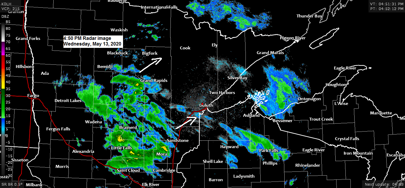
Lots of dry air and virga over the Northland today, you can thank the recent pattern which featured a cold/dry flow from the arctic. But, eventually will get enough moisture to build up which will allow for some light rain to move across northeast Minnesota and northwest Wisconsin tonight, but this won’t be a heavy soaking rain as we’re only looking at around 0.05 to 0.25 inches of rain by daybreak with higher amounts possible in northern Minnesota.
Simulated radar forecast ending at 7 AM Thursday, May 14, 2020 per 18z NAM-WRF model.
Source: https://weathermodels.com/

Source: https://lab.weathermodels.com/

Partial sun for Thursday with scattered showers especially during the afternoon and evening. Computer models are showing some weak instability developing during the day which could lead to isolated thunderstorm development later in the afternoon mainly across north-central Minnesota but severe weather is not expected. Highs on Thursday are forecast to be in the 60s but it will be cooler near Lake Superior. Winds will generally be out of the south or east at 5 to 15 mph.
Simulated radar forecast valid from 1 PM Thursday to 7 AM Friday per 18z NAM-WRF model.

We’ve gotten rid of the chilly/dry northerly flow and are now in a more zonal or west to east flow today with a few disturbances moving across the upper Midwest over the next 24-36 hours.
Source: Goes-16 water vapor imagery 5.13.2020; https://weather.cod.edu/

Looks like a potentially wet, cool, breezy and crappy weekend near Lake Superior as low pressure lifts NE out of the Southern Plains.
If this system tracks far enough north, then we will see some rain in Duluth late Saturday into Sunday, but a more southerly storm track would result in the rain area being pushed farther south and away from the Twin Ports.
In addition to the rain chances will be a breezy northeast wind this weekend with gusts to around 20 mph near Lake Superior. The combination of clouds, possible rain and a NE wind will keep our highs in the upper 30s to upper 40s around Lake Superior Saturday and Sunday.

Finally looks like will get a pattern change next week as a ridge becomes established across the Plains while a trough develops over the Rockies. For the Northland this new pattern will lead to warmer temperatures next week, in fact some parts of the Northland could have highs in the 70s and 80s ~May 19-22. Note: Temperatures near Lake Superior may be quite a bit cooler next week depending on the wind direction, east wind (cooler) southerly wind (warmer)
Source: 12z European ensemble model 5.13.2020; https://weathermodels.com/

*Warmest temp so far this month in Duluth, 68 degrees on the 2nd.
*The last time at least 0.25″ of precipitation fell in Duluth was on May 1st.
*May 2020 (thru the 12th) is running -5.5 degrees colder than normal in Duluth, while precipitation is nearly an inch below normal (-0.96″)
It’s been a very dry and cool May thus far across the Northland
| Here are the climate numbers for May 2020 (thru the 12th) Hibbing, Minnesota Average temperature: 39.6 degrees Departure: -8.1 degrees below normal Total precipitation: 0.29″ Departure: -0.65″ below normal International Falls, Minnesota Average temperature: 40.8 degrees Departure: -7.8 degrees below normal Total precipitation: 0.03″ Departure: -0.95″ below normal Ashland, Wisconsin Average temperature: 42.1 degrees Departure: -6.9 degrees below normal Total precipitation: 0.22″ Departure: -1.02″ below normal Brainerd, Minnesota Average temperature: 46.2 degrees Departure: -6.8 degrees below normal Total precipitation: 0.40″ Departure: -0.88″ below normal |
Source: https://mrcc.illinois.edu/


Note: Most of the Northland has only had around 10% of its normal precipitation from May 1st to May 12th, while up near the Ontario border precip totals so far this month have been around 5% of normal. Yes it has been quite dry lately!

Here’s a good example of a Southern Plains dryline!
Humid southerly flow with dew points in the 60s ahead of the dryline this afternoon, while southwest winds and much drier air were found behind the dry line with dew points in the teens, 20s and 30s.

Eventually we could see severe weather develop near and out ahead of the dryline late this afternoon into tonight with large hail, damaging winds and possibly a tornado or two across portions of the Southern and Central Plains.

Forecast for Duluth and Superior
.Tonight… Showers. Mostly cloudy with patchy fog possible late.. Low 40 to 45. Wind east to southeast 5 to 15 mph.
.Thursday… Patchy fog early. Mostly cloudy with partial clearing at times. Isolated late afternoon and evening showers. High 59 to 64 but cooler near Lake Superior. Wind east 5 to 15 mph.
.Friday… Partly to mostly sunny. High 60 to 65. Wind north to northwest 10 to 20 mph becoming east late.
| Normal temperatures for May 14 High 62 Low 40 Records for May 14 High: 91 degrees set in 1932 Low: 27 degrees set in 1921 Sunrise Thursday 5:34 AM CDT Sunset Thursday 8:36 PM CDT |
Thanks for reading!
Tim
Leave a Reply