Scattered showers and thunderstorms are possible at times over northeast Minnesota and northwest Wisconsin from tonight through the middle of the week. Severe thunderstorm chances are on the low side, however, due to weak winds aloft and generally weak shear, but there will be ample amounts of instability and moisture in place for thunderstorm development, will just need some kind of trigger to get convection to develop since we will be dealing with a warm layer of air aloft or a CAP which will make it difficult for thunderstorms to develop unless we have some kind of disturbance or frontal boundary to help lift the humid/unstable air.
Thunderstorms through the middle of the week will be capable of producing torrential rainfall with a few inches of rain not out of the question for areas that get hit by these storms. Precipitable water of 1.50″ to 2.00″ will be over most of the Northland the next few days while dew points range from around 65 to 75 degrees (lower values near Lake Superior) so again a ton of moisture for a thunderstorm to tap into.
The other big story this week will be the warm temperatures. High temperatures are forecast to be in the 80s this week with 90s possible especially later on in the week, Friday-Saturday time frame the way it looks now. The combination of the warm temps and muggy dew points will make it feel a tad uncomfortable outdoors over the next several days.
A cooler lake wind (10 to 20 mph) is expected to continue near Lake Superior through Wednesday with highs for lakeside locations ranging from the upper 50s to around 70 degrees, but it looks like will get a wind shift later this week, so very warm to hot temperatures will be possible even near Lake Superior by Thursday and Friday.
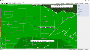
That swirl moving ENE across southern Minnesota this afternoon should be one ingredient needed for thunderstorm development this evening, another ingredient is a frontal boundary which is lifting slowly north into southern Minnesota this afternoon. Storms that develop across southern Minnesota and western Wisconsin this evening should make their way north into parts of our area later tonight.
Source: Goes-16 visible satellite loop 6.28.2020; https://weather.cod.edu/

Here’s a look at how things could play out through 7 PM Monday per two computer model forecasts.
18z NAM 3km model 6.28.2020
Source: https://weathermodels.com/

18z HRRR model 6.28.2020

1 to 2 inches or more of rain is possible through 7 AM Tuesday in parts of eastern Minnesota and northwest Wisconsin with half to one inch totals possible along the North Shore and Arrowhead. Lesser amounts of rain are forecast across western portions of the area, from International Falls to the Brainerd Lakes. Note: So far June 2020 is running 2nd driest June on record in Duluth (thru the 27th) will see if we get enough rain by the end of the month to get us out of a top 10 driest June on record in Duluth.
Source: https://lab.weathermodels.com/

One thing we haven’t seen a lot of lately is this! There is a chance that the Northland will have above normal precipitation through July 13th, maybe this will be the start of a wetter pattern? Will see!
Source: 12z European ensemble model 6.28.2020; https://weathermodels.com/

A few photos from this morning’s sunrise over Lake Superior as seen from Park Point Beach in Duluth, Minnesota. Enjoy!
June 28, 2020


Thanks for reading!
Tim
Leave a Reply