What looked like a potential heavy rain event impacting parts of the Northland tonight is looking less likely to happen as of late this afternoon as model guidance has been trending toward significantly lower rainfall amounts for tonight compared to what some of them had been showing this morning.
The pattern we’re in right now is very complex, however, and it’s still possible we could see heavier showers and thunderstorms train over the same location for a few hours tonight, and if this does happen there would be a chance for flash flooding, but with how dry its been in most of the Northland as of late, this may reduce the potential for flash flooding unless we see some real hefty rain totals, something like 3-5″+ in a short period of time, and the chances we see those types of rainfall amounts occur tonight look quite low at the moment.
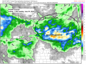
Look at how much the HRRR model has changed in 6 hours today. The first image shows forecast rainfall totals through 7 AM Tuesday per the 12z/7 AM Monday model run, while the second image is one of the newest runs from 18z/1 PM Monday, again showing forecast rainfall totals through 7 AM Tuesday. Big change in the HRRR model for rainfall totals tonight!
Source: https://weathermodels.com/


Here’s a simulated radar forecast valid from 7 PM Monday to 7 PM Tuesday.
Source: 18z NAM 3km model 6.29.2020; https://weathermodels.com/

Rainfall Reports from Sunday night-Monday, June 28-29, 2020
Source: https://www.weather.gov/dlh/; https://mesowest.utah.edu/
Note: Totals listed below are thru 1 PM Monday, June 29, 2020.
Finlayson, MN: 2.24″
6 NNW Winter, WI: 1.85″
Hinckley, MN: 1.10″
Rock Creek, MN: 1.00″
2 WSW Riverside, WI: 0.75″
Glidden, WI: 0.73″
Hayward, WI: 0.72″
Clam Lake, WI: 0.70″
Minong, WI: 0.67″
Superior, WI: 0.65″
Washburn, WI: 0.59″
Barnes, WI: 0.55″
Solon Springs, WI: 0.52″
1 SSW Barnum, MN: 0.50″
Siren, WI: 0.45″
McGregor, MN: 0.42″
Superior Airport: 0.41″
Ashland, WI: 0.38″
Buyck, MN: 0.25″
Saginaw, MN: 0.22″
Brainerd, MN: 0.20″
Duluth Airport: 0.18″
Hill City, MN: 0.18″
2 N Cloquet, MN: 0.13″
Silver Bay, MN: 0.12″
Grand Rapids, MN: 0.07″
Isabella, MN: 0.06″
Orr, MN: 0.05″
International Falls, MN: 0.04″
Flooding/Flash Flooding occurred late last night into today from portions of southern Minnesota to west-central Wisconsin where 4 to 8 inches or more of rain fell in less than 24 hours!
Source: https://lab.weathermodels.com/

Here’s a zoomed in view of radar estimated rainfall amounts from Sunday night and Monday morning. Note: Those white and gray areas indicate 4 to 8″+ rainfall totals.

Several hours of torrential rain producing thunderstorms earlier today on the south/southeast side of the MCV which impacted southern Minnesota into west-central Wisconsin.
Radar loop below runs from 1 AM Monday to 7 AM Monday, June 29, 2020.
Source: https://weather.cod.edu/

The black outlined area is where we really need the rain the most – Here’s the precipitation anomaly % of Normal over the past 30 days.
Note: Duluth’s precipitation deficit since January 1st is >6.50″.
Source: https://lab.weathermodels.com/

One Mesoscale Convective Vortex lifting north into Ontario province today while another one heads ESE out of western Minnesota, these little spins in the atmosphere show up nicely on satellite imagery.
Source: Goes-16 visible satellite loop 6.29.2020; https://weather.cod.edu/

Although it will be warm over the next few days (highs mid 70s to mid 80s, cooler lakeside) it looks even warmer late this week with widespread near 90 degree temperatures possible in northeast Minnesota and northwest Wisconsin for Thursday, Friday and Saturday (July 2-4)
A big ridge parked over the Plains will extend north into the upper Midwest late this week while a trough and thunderstorm clusters erupt on the west and north side of said ridge.
Source: https://www.wpc.ncep.noaa.gov/

Thanks for reading!
Tim
Leave a Reply