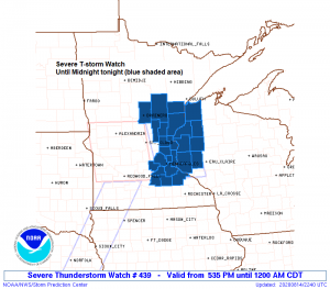
5:58 PM Friday – A severe thunderstorm watch has been issued for eastern Minnesota and western Wisconsin effective this Friday afternoon from 5:35 PM until Midnight CDT.
Primary threats include
Damaging wind gusts to 70 mph
Large hail to 1.5 inches in diameter
A tornado or two possible
Counties in the Northland included in this severe thunderstorm watch are: Crow Wing, Aitkin, Carlton, Pine, Douglas, Burnett and Washburn including the cities of Brainerd, Aitkin, Hill City, McGregor, Cloquet, Carlton, Moose Lake, Hinckley, Pine City, Superior, Solon Springs, Minong, Danbury, Grantsburg, Siren, Spooner and Shell Lake.
A severe thunderstorm watch means conditions are favorable for severe thunderstorms in and close to the watch area. Persons in these areas should be on the lookout for threatening weather conditions and listen for later statements and possible warnings. Severe thunderstorms can and occasionally do produce tornadoes.
We’re seeing an explosion of strong to severe thunderstorms late this afternoon across western, central and southern Minnesota as a potent low pressure system heads NE out of the Dakotas.
Forcing associated with the upper level trough and area of low pressure has spread far enough east into the warm, humid and unstable air to cause numerous strong to severe storms late this afternoon. Note: How storms fire up right on the edge of the dry air mass shown in yellow colors on the image.
Source: Goes-16 water vapor imagery; https://weather.cod.edu/

Expect showers and thunderstorms to move from southwest to northeast across northeast Minnesota and northwest Wisconsin through late this evening.
Storm timing for Duluth looks to be roughly from 7 to 10 PM this evening.
Storms will be capable of producing torrential downpours and lightning along with the possibility for damaging wind gusts and hail. Note: The threat for severe weather (damaging gusts and hail) is greatest across east-central Minnesota and northwest Wisconsin through late this evening.
Flash flooding is also a concern through this evening primarily over north-central Minnesota where thunderstorms have been moving over the same location for a few hours, and expect this to continue for a few more hours before the rain ends later this evening.
Radar loop from 3 PM to 5:50 PM Friday, August 14, 2020.

Thanks for reading!
Tim
Leave a Reply