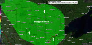
For the most part this weekend looks pretty nice in northeast Minnesota and northwest Wisconsin with some sunshine expected both Saturday and Sunday, but there is one potential trouble spot, and that comes late Saturday afternoon through Saturday evening, this is when a few showers and thunderstorms are possible across the Northland as a trough passes SE through the area.
Moisture looks pretty limited for storms on Saturday with dew points mostly in the 50s to around 60 degrees, but strong winds aloft coupled with enough instability with CAPE to around 1000 J/kg should be enough to trigger a few fast moving storms capable of producing hail and gusty winds late Saturday afternoon into Saturday evening, but coverage of these storms look pretty isolated at the moment.
High temperatures on Saturday and Sunday will mainly be in the 70s.
Winds will be a little gusty overnight into Saturday morning in wake of the low pressure system moving through this evening. Winds will shift northwest by late tonight at 10 to 20 mph with higher gusts overnight into Saturday morning, then winds will become southwest Saturday afternoon, then shift back to the northwest on Sunday.
18z NAM 3km simulated radar forecast valid from 1 PM Saturday to 1 AM Sunday.
Source: https://weathermodels.com/

Thanks for reading!
Tim
Leave a Reply