It’s been a very dry year in the Twin Ports, but there is some good news on the way (at least in the short term) as we do have a few rain chances lined up into next week, but with a precipitation deficit of over 9″ now for the year, it’s going to take several significant precipitation events to get us at least somewhat closer to normal for the year as we’re basically 3 months worth of precipitation below normal.
2020 Precipitation Total (thru September 22nd) 14.62″ which is -9.16″ below normal.
September 2020 Precipitation total (thru the 22nd) 0.43″ which is -2.65″ below normal.
Note: Even if we were to get our average precipitation total from October thru December which is 6.15″ we would still finish well below normal for the year in Duluth, in other words will need September to finish strong in terms of rainfall, and then will need a wet and or snowy pattern to lock in for October, November and December if we have any chance at all to get back to normal or closer to normal in 2020.
Here’s a look at every single precipitation event we’ve had so far this year in Duluth (ending on September 22nd)
Note: From about May thru September you need roughly an inch or so of precipitation a week to keep drought from developing. That just hasn’t been the case around here for several months now, although July was an exception as it was a fairly wet month in Duluth, but from about mid-August to now we’ve gone in the wrong direction, again.
Source: https://mesonet.agron.iastate.edu/

Green line represents 2020 accumulation while the brown line represents where we should be in terms of precipitation.
2020 started out pretty good in terms of precipitation in Duluth as we were running close to normal thru most of April, but then things changed considerably starting in May.
Perhaps this is the start of a longer lasting and worsening drought around here which could last for years? Doubtful, but you never know!

Total precipitation and the percent of mean so far for September 2020.
Cities such as Brainerd, Aitkin, Duluth, Hinckley and Solon Springs have only had 10% of their normal precipitation so far this month while much of the rest of the Northland has seen around 25% of their normal precipitation so far this month. A very dry month up to this point!
Source: https://mrcc.illinois.edu/

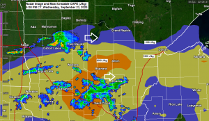
There continues to be a marginal risk of severe thunderstorms for tonight across portions of north-central and east-central Minnesota and for all of northwest Wisconsin (dark green area on map)
Hail to 1 inch in diameter or quarter size, and wind gusts to 60 mph are the primary threats if an isolated severe storm develops tonight.

A look at the system which will affect the Northland tonight as it digs SE today out of southern Manitoba per Goes 16 water vapor imagery.
Source: https://weather.cod.edu/

Here’s the 18z NAM 3km radar forecast ending at 7 AM Thursday.
Looks like the best chance for some rain tonight will be over southern portions of the Northland, especially from the Brainerd Lakes toward the Twin Ports to Two Harbors, including all of northwest Wisconsin, with only a few showers possible over northern Minnesota into the tip of the Arrowhead.

Rainfall amounts of a quarter to half inch are expected tonight over portions of east-central Minnesota and most of northwest Wisconsin, but there is a chance for higher amounts on the order of 1 to 2 inches if thunderstorms setup over the same location for a few hours. Lesser amounts of rain expected farther north tonight.
Source: https://lab.weathermodels.com/

Cooler temperatures will move into the Northland on Thursday as tonight’s cold front settles south of our area. Highs Thursday will mainly be in the 60s, but will only be in the 50s closer to Lake Superior. It will also be a breezy day near Lake Superior on Thursday with a northeast wind gusting 20 to around 30 mph.

Our next shot at getting some rain after tonight comes on Friday, but there are differences in model guidance regarding the timing of when a cold front moves through the Northland, but regardless of that, it looks like the best chance for some showers on Friday will be across northern Minnesota, and also from far eastern Minnesota into northwest Wisconsin, this area will also have a chance for a few thunderstorms Friday afternoon or Friday evening.
Source: https://www.wpc.ncep.noaa.gov/

I’m still seeing very good model agreement today regarding the temperature forecast and overall pattern for next week per EPS and GEFS models.
It looks like will be stuck in the 40s and 50s for daytime highs across the Northland for most of next week, in fact there are a few computer models today showing enough cold air to support the possibility for a few snow flurries sometime mid to late next week in far northeastern Minnesota.
Source: https://weathermodels.com/

Source: https://www.tropicaltidbits.com/

This is an excellent shot of Post-Tropical Cyclone Teddy from Tuesday evening, September 22nd, 2020 – This powerful storm impacted portions of Nova Scotia and Newfoundland today.

Thanks for reading!
Tim
Leave a Reply