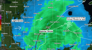
Snow continues to fall across the Northland this evening, but is expected to taper off from SW-NE overnight. Patchy drizzle, freezing drizzle and snow showers are still possible around daybreak, but the accumulating snow should end early Wednesday morning.
Note: Snow is expected to end in Duluth and Superior ~1 to 3 AM tonight. 2.3″ of snow has been reported at the Duluth Airport today (thru 8 PM) The record snowfall for October 20th is 3.4″ set in 1936.
Widespread snowfall of 2 to 5 inches has been reported so far today (thru 8 PM) across southern portions of the Northland with a few 6 inch totals in the Brainerd area.
| Snowfall Reports from around the Northland Tuesday, October 20, 2020 Source: https://www.weather.gov/dlh/ Note: Totals listed below are thru 7 PM, October 20. 5 SE Saint Mathias: 6.5″ Brainerd, MN: 6.0″ Nisswa, MN: 5.0″ 3 ESE Barrows, MN: 5.0″ 2 W Hayward, WI: 5.0″ 3 SSW Finlayson, MN: 4.8″ 8 W Pine Center, MN: 4.5″ Willow River, MN: 4.5″ 3 NE Brainerd, MN: 4.5″ Hertel, WI: 4.5″ Trego, WI: 4.5″ 4 NNW Brainerd, MN: 4.5″ 4 NNW South Range, WI: 4.0″ 2 SSE Pine River, MN: 3.5″ 2 ENE Holyoke, MN: 2.5″ Duluth Airport: 2.3″ (total thru 8 PM) 3 N Amnicon Falls S.P. 2.2″ Rice Lake, MN: 2.0″ 12 N Grand Rapids, MN: 1.5″ |
Tim
Leave a Reply