12:49 PM 10/21/2020 – We’ve seen quite a change in the forecast models (except for the GFS model) regarding Thursday’s system as they have pushed the system further south which has shifted the main axis of snow further south compared to how it looked 24 hours ago.
The GFS model has led the way on its storm track and colder scenario with Thursday’s system, and now we’re seeing the other models trend toward the GFS solution.
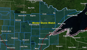
The least amount of snow on Thursday looks to be across the Borderland including the International Falls area, and its possible it could even extend further south reaching into the Iron Range.
The greatest amounts of snow are expected to setup across east-central Minnesota into northwest Wisconsin, including the Brainerd Lakes and Twin Ports areas.
I think there’s a pretty good chance will see the NWS issue some sort of winter weather headline for the rest of northwest Wisconsin by later today (red outlined area)
The white outlined area is expected to get less snow than what it looked like yesterday, so we could see the winter storm watch cancelled, or changed to an advisory by later today for that area, including Bigfork, Cook and Ely.
The pink outlined area is where the greatest snowfall accumulations appear to be setting up for Thursday, but this area may still shift a bit north or south through tonight. Note: Will likely see the watch change to a warning or advisory by later today in the pink outlined area.

Temperatures aloft look cold enough for frozen precipitation across the area on Thursday, so it will come down to surface temps as to what type of precip we see, and right now those look to be in the 32 to 35 degree range which should be cold enough for mainly snow.
There could be enough warming within about 5 miles of Lake Superior for precipitation to start as snow or a mix on Thursday, but then possibly switch over to mainly rain Thursday afternoon if surface temps warm enough, and that is a possibility.
Still some timing differences as to when the snow/precipitation will begin falling Thursday, but it looks like things will get going during the morning, spreading from SW-NE.
I’ll have a snowfall accumulation map posted later this afternoon for Thursday’s event.
| Snowfall Reports from Tuesday, October 20, 2020 Source: https://www.weather.gov/dlh/ 5 NW Two Harbors, MN: 7.1″ 1 NW Baxter, MN: 7.0″ Gile, WI: 7.0″ 9.8 W Ashland, WI: 6.8″ 4.6 NE Duluth, MN: 6.5″ Kettle River, MN: 6.5″ 2 W Hayward, WI: 6.0″ Duluth Airport: 5.9″ Brainerd, MN: 5.7″ 1.2 W Solon Springs, WI: 5.6″ Proctor, MN: 5.5″ 3 N Butternut, WI: 5.5″ 1 WSW Cloquet, MN: 5.0″ 1 W Cornucopia, WI: 5.0″ 4 N Brainerd, MN: 5.0″ 7 WSW Pine River, MN: 4.8″ 7 N McGregor, MN: 4.8″ 3 N South Range, WI: 4.7″ 4 S Bruno, MN: 4.5″ 3 E Wright, MN: 4.5″ Oulu, WI: 4.5″ 4.3 W Superior, WI: 4.3″ Embarrass, MN: 4.0″ Blackberry, MN: 4.0″ 1 ENE Hoyt Lakes, MN: 4.0″ 2 SW Two Harbors, MN: 3.2″ Babbitt, MN: 3.0″ Silver Bay, MN: 2.9″ 3 E Orr, MN: 2.8″ 4.4 W Grand Marais, MN: 2.3″ International Falls, MN: 1.8″ |
Note: Record Daily Snowfall set at Duluth, Minnesota on Tuesday, October 20, 2020 with 5.8 inches of snow. The old record was 3.4 inches set on October 20, 1936.
It’s been a snowy October in Duluth with 7.7 inches of snow so far this month. The average October snowfall in Duluth is 2.3 inches.
Here are the top 5 snowiest Octobers on record at Duluth, Minnesota
1) 14.0 inches set in 1933
2) 11.5 inches set in 1925
3) 11.1 inches set in 2017
4) 9.7 inches set in 1995
5) 8.1 inches set in 1966
Note: The bulk of the snow with the Halloween Mega-Storm in 1991 actually fell on November 1st when 24.1″ of snow fell in Duluth. On Halloween itself, Duluth picked up 4.2″ of snow, and that is why October 1991 isn’t the snowiest October on record, it’s all about timing.
Thanks for reading!
Tim
Leave a Reply