Unlike the last two snow events which covered a large portion of the Northland, the one on Thursday is smaller in size, which makes Thursday’s forecast a tough one as any slight shift in the storm track and where the main band of precipitation sets up will make or break the forecast. In other words there is bust potential with Thursday’s system.
Another complicating factor is Lake Superior and whether or not a northeasterly wind coming off the lake will warm the temperature enough to cause more rain than snow within about 5 miles of Lake Superior on Thursday, some of the models show this happening with temperatures warming to 35 to 39 degrees near Lake Superior by Thursday afternoon, but other models keep the cold air locked in causing snow to be the main precipitation type on Thursday.

Snow or a rain/snow mix is expected to arrive in Duluth and Superior around 7 AM to 10 AM Thursday with precipitation then continuing into early Friday morning before ending.
18z NAM 3km model radar forecast valid 3 AM Thursday to 7 AM Friday.
Snow in blue, rain in green, mixed precip in pink.
Source: https://weathermodels.com/

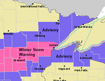
Winter Storm Warning in pink; Winter Weather Advisory in purple. These winter weather headlines are in effect for Thursday into early Friday morning. Plan on slippery road conditions on Thursday which may impact the morning or evening commute.
For Duluth: Winter Storm Warning in effect from 4 AM Thursday to 4 AM Friday.
For Superior: Winter Weather Advisory in effect from 4 AM Thursday to 7 AM Friday.
Source: https://www.weather.gov/dlh/
Here’s my snowfall forecast for Thursday.
4 to 7 inches across east-central Minnesota and portions of northwest Wisconsin including Brainerd, Aitkin, Moose Lake, Hinckley, Solon Springs and Iron River.
2 to 4 inches for Walker, Cass Lake, Grand Rapids, Hibbing, Two Harbors, Silver Bay, Grand Marais, Danbury, Minong, Spooner, Hayward, Winter, Washburn and Ashland.
A trace to 2 inches across far northern Minnesota including Bigfork, Cook and Ely.
Note: There is still a chance that these snowfall gradients will shift a bit either a little north or south over the next 12 hours.

Snowfall forecast for Thursday zoomed in on the Twin Ports.
Note: Low confidence forecast below the hill in Duluth as we could see a period of snow before Noon Thursday change over to rain or a mix during the afternoon if temperatures warm enough.
Snowfall totals of only around an inch or less are expected on Park Point on Thursday.
1 to 3 inches of snow for Superior, and 2 to 4 inches of snow in the West End, West Duluth, Gary and Fond du Lac areas on Thursday. Totals could end up higher or lower in these areas on Thursday depending on whether or not precip stays mostly snow, or if we see more of a mix or even rain.
Higher confidence for precipitation to remain in the form of snow on top of the hill in Duluth on Thursday with potential for accumulations of 4 to 7 inches. Note: Snowfall record at Duluth for October 22nd is 2.5 inches set in 1917. Pretty good chance will break that record with Thursday’s snowfall.

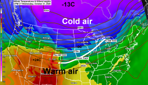
What an incredible looking water vapor loop from today, Wednesday, October 21, 2020.
It’s an active weather pattern!
Source: https://weather.cod.edu/

Thanks for reading!
Tim
Leave a Reply