12:30 PM 10/22/2020 – Some winter storms are easier to forecast than others, but unfortunately today’s winter storm is proving to be a difficult one to get a handle on, even as of early this afternoon I still don’t have much confidence in my forecast (where’s the weather dartboard when you need it)
Radar loop from 7 AM to 12:23 PM, Thursday, October 22, 2020 – You can clearly see where the two main bands of precipitation have setup this morning and early this afternoon, one west of Duluth, the other southeast of Duluth, dry air between those two areas of precipitation. Will that dry area fill in through the afternoon? Models say it will, so will see what happens through the afternoon.
Note: Heavier precipitation shows up as green and yellow colors on the loop below.
Source: https://weather.cod.edu/

What to do, what to do? It’s hard to change a forecast when you see model guidance continue to show a decent amount of precip/snow in Duluth this afternoon into this evening, but then you look at radar trends and see how things have been progressing over the past few hours, and you get the feeling that this storm will end up producing less snow than what was previously forecast for Duluth and Superior.
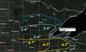
Here’s my updated snowfall forecast thru tonight zoomed in on the Twin Ports.
Note: It’s certainly possible that I’ll have to tweak these amounts even more by late this afternoon, but for now here’s what I’m going with.
Higher elevation (on top of the hill) 2 to 4 inches with cold enough temps in place for snow.
Lower elevation (below the hill) Anywhere from a trace to 2 inches of slushy snow with some rain possible as well.

The main trough/source of lift is moving east out of the Dakotas this afternoon so we should see some heavier precipitation in the form of snow, rain or sleet across portions of east-central Minnesota and northwest Wisconsin through this evening, with only light snow (if that) farther north across northern Minnesota into the Arrowhead.

Water vapor loop from Thursday, October 22, 2020 – Loop time ends at 12:11 PM CT.
Source: https://weather.cod.edu/

Surface analysis from early Thursday afternoon, October 22, 2020.
A large temperature contrast in place today with 10s over Montana to the 70s and 80s from southern Iowa and central Illinois on south.

Thanks for reading!
Tim
Leave a Reply