6 PM 10/22/2020 – 2.0 inches of snow so far today at the Duluth Airport which brings the monthly total to 9.8 inches. October 2020 currently ranks as the 4th snowiest October on record at Duluth, Minnesota.
Daily snowfall record at Duluth for October 22nd is 2.5 inches set in 1917. This record has a good chance of being broken this evening.
Winter Storm Warning (pink) and Winter Weather Advisory (purple) remain in effect across most of the Northland through tonight.
Note: Winter Storm Warning for Duluth and Superior has been cancelled. Winter Weather Advisory now in effect until 7 AM Friday.
Road conditions will vary considerably across the area tonight into Friday morning. Slow down and use caution while traveling.
Source: https://www.weather.gov/dlh/

Links to road conditions
Minnesota – https://new.511mn.org/
Wisconsin – https://511wi.gov/
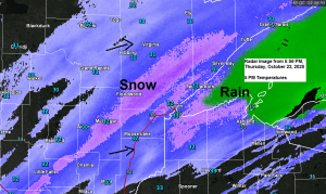
Snow will continue to fall across portions of east-central and northeast Minnesota this evening while a mix of snow, sleet and rain continues across northwest Wisconsin. Locations within about 5 miles of Lake Superior will continue to see mostly rain or a rain/snow mix this evening.
Precipitation diminishes from SW-NE after Midnight with some lingering flurries/snow showers expected Friday morning.
20z/3 PM HRRR model radar forecast ending 9 AM Friday.
Source: https://weathermodels.com/

| Snowfall Reports from Thursday, October 22, 2020 Source: https://www.weather.gov/dlh/ Note: Totals listed below are thru 4 PM Thursday. 5 E Leader, MN: 6.0″ 7 WSW Pine River, MN: 5.0″ Brainerd, MN: 4.0″ Emily, MN: 4.0″ 1 N Motley, MN: 4.0″ 3 NE Brainerd, MN: 3.3″ Duluth Airport: 2.0″ (thru 5 PM Thursday) 4 S Bruno, MN: 1.6″ Gull Lake Dam, MN: 1.2″ 8 NNW Coleraine, MN: 1.0″ |
Additional snowfall for tonight

Total snowfall accumulations of around 2 to 4 inches are expected tonight in higher elevation in Duluth, with a trace to 2 inches in lower elevation, although I’m leaning more toward trace amounts more than 2 inch amounts in lower elevation tonight.

It took forever for the dry air to saturate today in the Twin Ports which is why the snow or rain started later than what was expected by a good 6 hours or so, but eventually the dry layer was kicked out thanks in part to Lake Superior which helped moisten the atmosphere, plus additional moisture/lift from the low/trough approaching from the Rockies.
Note: Radar loop below starts ~5 AM Thursday, ends around 5 PM Thursday.
Source: https://weather.cod.edu/

A large temperature gradient helping to fuel today’s storm with 10s and 20s across the Northern Rockies to the 80s across portions of the Midwest and South.

Just your ordinary day in 2020 as a plume of wildfire smoke lifts northeast out of northern Colorado and into Minnesota and Wisconsin where it mixed in with snow and sleet across parts of the area today. Reports of a brownish tint to the snow cover in some areas due to this wildfire smoke today.
Source: https://weather.cod.edu/

Smoke plume really shows up nicely on visible satellite imagery today, note the brownish plume stretching from northern Colorado to central Minnesota to Lake Superior today.

Natural Color-Fire Imagery with hot spots showing up in pink.
Satellite loop from today, Thursday, October 22, 2020.

Thanks for reading!
Tim
Leave a Reply