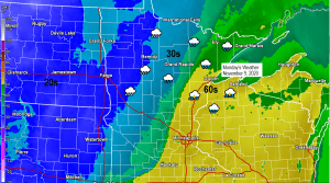
A strong cold front will be moving east through the Northland on Monday. A very humid air mass will be in place east of this front with PWATS of 1.00-1.40″ along with dew points in the 50s, with this much moisture around there will a chance for some heavy rain showers across parts of the Northland on Monday, otherwise expect light to moderate rain at times through the day. Isolated thunderstorms are possible as well as there will be some elevated CAPE over the area on Monday.
Colder air will be working east reaching north-central Minnesota by Monday afternoon where temps will go from the 50s early in the morning to the 30s by Monday afternoon, in fact some of the rain could become mixed with sleet or snow roughly west of a line from Walker to International Falls Monday afternoon with snow accumulations up to an inch possible.
Warm air will remain over eastern Minnesota and northwest Wisconsin for one more day with highs Monday in the upper 50s to upper 60s, but cold air will reach these areas by Monday night and Tuesday when temperatures will fall into the 30s.
Rainfall of a half to one inch is possible across much of northeast and east-central Minnesota and northwest Wisconsin thru late Monday evening while amounts of around a quarter to half inch are expected in the far northwest portion of the area, from around Cass Lake to Bigfork to International Falls.
Source: https://lab.weathermodels.com/

Here’s the 18z HRRR model radar forecast valid 7 PM this evening thru late Monday night (12 AM)
Rain in green, snow in blue, mix precipitation types in pink/purple colors.
Source: https://weathermodels.com/

A strong trough with snow and cold air remains over the western U.S. today, while record breaking warmth continues under a massive ridge across the eastern half of the U.S.
Note: Temperatures were warmer in northeast Minnesota compared to Arizona on this 8th day of November, crazy stuff!

Temperatures across the Northern Rockies are running anywhere from 20 to as much as 50 degrees colder this afternoon compared to Saturday afternoon, and this cold air will be heading farther east over the next 24 hours.
Source: https://lab.weathermodels.com/

Record Highs set today, Sunday, November 8th, 2020
Brainerd, MN: New record 70 degrees; old record 69 degrees set November 8th, 1931.
Duluth, MN: 69 degrees – this ties the record high for November 8th which was set in 1999.
Incredibly high 500mb heights of 588 decameters with a strong ridge centered over the Mid-Atlantic this afternoon.

Strong trough out west, big time ridge to the east – it all shows up nicely on water vapor imagery today, Sunday, November 8, 2020.
Source: https://www.star.nesdis.noaa.gov/

A powerful winter storm continues over portions of the Northern Rockies this afternoon, with blizzard conditions occurring at times over parts of Montana.
Source: Goes-16 visible satellite; https://weather.cod.edu/

Computer models are in very poor agreement on whether or not we see some snow in parts of the Northland Tuesday into early Wednesday.
By far the Euro guidance has remained the snowier solution for several days now, and the UK and Canadian models side with the Euro solution.
The GFS model has been going back and fourth between snow or very little snow across our area and then you have the NAM model which is on the dry side on Tuesday as they don’t really show any sort of system developing near our area, so with this much uncertainty still showing up in the models I’ll stay the course for now (see map below) but hopefully the models will come into better agreement over the next 24 hours because this is pretty awful right now considering this potential event is only 2 days away.
If we do get some snow on Tuesday, it still doesn’t look like it would be a major storm for our area, with perhaps a few inches of snow accumulation during the Tuesday afternoon-Tuesday night time frame.
Stay tuned

Record breaking warmth across the Northland last week – Below are the record high temperatures which were set during the week of November 1st, 2020.
Duluth, Minnesota
11/4: 73 degrees
11/5: 75 degrees
International Falls, Minnesota
11/3: 70 degrees
11/4: 74 degrees
Ashland, Wisconsin
11/3: 75 degrees
11/6: 78 degrees
11/7: 70 degrees
Brainerd, Minnesota
11/3: 72 degrees
11/4: 75 degrees
11/6: 75 degrees
11/7: 67 degrees
Hibbing, Minnesota
11/3: 70 degrees
11/4: 71 degrees
11/6: 70 degrees
11/7: 64 degrees
***Record Warm Minimum Temperatures set on Saturday, November 7th, 2020***
Ashland, Wisconsin: New record 58 degrees; old record 50 degrees set on November 7th, 2016.
Brainerd, Minnesota: New record 54 degrees; old record 47 degrees set on November 7th, 1975.
Last week was one for the record books! Incredible and persistent warmth across the upper Midwest and Western Great Lakes with average temps for the week some 10 to 15 degrees above normal.
Source: https://mrcc.illinois.edu/

Last week’s very warm temperatures weren’t just confined to our area though as the warm temps were widespread from the western U.S. to the Central and Northern Plains to the Great Lakes.

Thanks for reading!
Tim
Leave a Reply