From an October which was the 2nd snowiest on record at Duluth (12″ of snow) to a November which is running nearly +15 degrees warmer than average so far (absurd) and we’ve also recorded our warmest November temperature ever in Duluth this month (75 degrees on 11/6/2020) also, 7 days of highs 60 F or warmer with 3 of those days 70 F or warmer, it’s only fitting the pattern changes to one featuring colder temperatures and some snow. The weather has been crazy extreme lately!
By the way, Duluth is still running >9″ below normal in precipitation for 2020, but with 19.00″ of precipitation so far this year, 2020 won’t be the driest year on record in Duluth, so we have that going for us.
A reality check is here! Highs on Tuesday will only be in the mid 20s to mid 30s across the Northland. We could see some icy spots develop in some parts of the area tonight due to Monday’s rainfall and falling temperatures tonight, so be careful on those roads and sidewalks as they could become icy in spots.
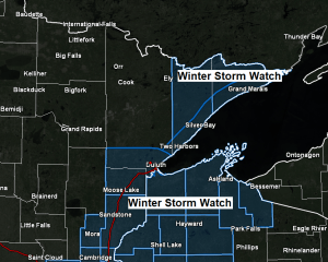
A winter storm watch has been issued for parts of northeast and east-central Minnesota and for all of northwest Wisconsin. This watch is in effect from Tuesday afternoon through late Tuesday night.
Some cities included in the winter storm watch are…Grand Marais, Silver Bay, Isabella, Two Harbors, Duluth, Cloquet, Moose Lake, Hinckley, Pine City, Superior, Solon Springs, Washburn, Bayfield, Ashland, Hurley, Grantsburg, Siren, Danbury, Minong, Spooner, Shell Lake, Hayward and Winter.
Heavy snow possible in the watch area late Tuesday afternoon into early Wednesday. Plan on slippery road conditions beginning late Tuesday afternoon or Tuesday evening and continuing into Wednesday morning.
Here’s my preliminary snowfall forecast for Tuesday’s event.
Note: One thing I am concerned about is how quick this system moves through, so although heavy snow is possible in parts of the area, it might not last very long, this could cut down on accumulations, so instead of 4-6″+ in the heaviest zone, we could be more in the 3-4″ range instead. Also, the axis of highest snow totals (purple area on map) could shift a little further west or east depending on the track of this storm. It’s also possible the snowfall gradients will tighten up a lot more compared to what is shown on the map below, but I’ll wait until Tuesday morning to change that if need be.
For Duluth and Superior: Most of the day Tuesday should be dry, in fact we could even see some sunshine at times. Snow moves into the Twin Ports around 4-8 PM Tuesday, with snow continuing into the overnight before coming to an end around 4-6 AM Wednesday. I’m going with 2-4 inches of snow accumulation in Duluth and Superior, but notice how close I have us to the 4-6″+ totals, so if the low tracks a bit more west, that would put us into the higher snow totals.

There is also a chance for some light ice/sleet accumulations over parts of northwest Wisconsin late Tuesday afternoon into early Tuesday evening.

The upper level dynamics with Tuesday’s system are impressive with a negative tilted trough lifting NE into the upper Midwest. There should be a period of rather strong lift as this system moves through with potential for a 4 to 6 hour window of heavy snowfall rates approaching 1″/hour Tuesday evening/overnight somewhere from east-central Minnesota to northern Wisconsin, and possibly as far north as the North Shore of Lake Superior.
Source: 18z RGEM model; https://www.tropicaltidbits.com/

Here’s the 18z NAM 3km radar forecast thru 7 AM Wednesday.
Rain tapers off later tonight in northwest Wisconsin, and then it looks mainly dry across the Northland through early Tuesday afternoon.
Precipitation from the next system lifts NNE into southern/eastern portions of the Northland late Tuesday afternoon/early Tuesday evening the way it looks now.
Green – Rain
Blue – Snow
Pink/Purple – Mix precipitation types
Source: https://weathermodels.com/

| Rainfall Reports for Monday, November 9, 2020 Source: https://mesowest.utah.edu/; https://www.weather.gov/dlh/ Note: Totals below are thru 3 PM Monday. Cloquet, MN: 1.58″ Moose Lake, MN: 1.58″ Kettle River, MN: 1.44″ Saginaw, MN: 1.38″ Isabella, MN: 1.37″ Duluth Airport: 1.17″ Ely, MN: 1.10″ 2 SSE Pine River, MN: 1.00″ Grand Rapids, MN: 0.96″ Two Harbors, MN: 0.95″ Eveleth-Virginia, MN: 0.88″ Breezy Point, MN: 0.88″ Hill City, MN: 0.86″ Pine River, MN: 0.85″ Esko, MN: 0.82″ Longville, MN: 0.78″ Chisholm-Hibbing Airport: 0.76″ Cook, MN: 0.73″ Hinckley, MN: 0.70″ McGregor, MN: 0.67″ Deer River, MN: 0.66″ Walker, MN: 0.62″ Silver Bay, MN: 0.61″ Superior Airport: 0.46″ Minong, WI: 0.34″ Grand Marais Airport: 0.33″ Solon Springs, WI: 0.33″ International Falls, MN: 0.28″ Siren, WI: 0.25″ |
Note: Duluth, Minnesota set a new daily precipitation record for November 9th, with 1.18″ of rain today. The previous record was 0.75″ set November 9th, 1919.

Radar loop of today’s widespread rainfall event.
Several waves of downpours (orange and red colors on the animation) throughout the day across parts of the Northland, and there was even some thunder today, how’s that for a November day?
Note: Loop time from ~6 AM to 4 PM Monday, November 9, 2020.
Source: https://weather.cod.edu/

Now that is a powerful cold front! Check out these temperatures from late Monday morning. 38 degrees at Grand Rapids, 60 degrees at Duluth, 71 degrees at Ashland, wow!
Note: Temperature at the Duluth Airport fell from 61 degrees at Noon today to 39 degrees at 3 PM.

500mb heights are a fallen as a colder air mass moves east into the upper Midwest today, while our possible wintry system for late Tuesday makes its way through the Southern Rockies today. Meanwhile to the east, a powerful upper level ridge remains in place.

There’s a lot of moving parts to Tuesday’s system, but the basic pattern includes a strong trough to the west and a massive ridge to the east while a SW flow occurs between the trough and ridge. Usually this type of pattern will lead to a storm or two tracking from the Rockies to the Great Lakes, and this is what will see happen on Tuesday into early Wednesday.
Water vapor loop for Monday, November 9, 2020.
Source: https://weather.cod.edu/

Thanks for reading!
Tim
Leave a Reply