11:40 AM Tuesday – Will see the snow and freezing rain currently across south-central Minnesota late this morning continue to lift N-NE through early this evening. Note: Looks like the bulk of the precipitation with this storm will remain southeast of a line from around Walker to Bigfork to International Falls.
Updated my snowfall forecast just a bit, but no real drastic changes at the moment.
4-6 inches of snow is possible in Duluth and Superior, with snow arriving in the Twin Ports around 4-7 PM today. Snow tapers off around 2-4 AM Wednesday. There could be a period/s of sleet early this evening, and if the sleet lingers longer than expected, that could cut down on snow totals just a bit.

Ice accumulations of up to one tenth of an inch are possible in parts of northwest Wisconsin late this afternoon and early this evening (orange outlined area on map)

Precipitation moves into southern portions of the Northland from mid to late afternoon, and will then continue to lift north early this evening, reaching Duluth and Superior ~4 to 7 PM.
Here’s the radar forecast ending 7 AM Wednesday per 12z NAM 3km model.
Blue – Snow
Pink/Purple – Mix precipitation types
Source: https://weathermodels.com/

As I pointed out yesterday, this is a very dynamic system with very strong lift, but it will move through quickly, lasting roughly 6-8 hours in any given location.
The heaviest precipitation whether it be snow, sleet or freezing rain is forecast to lift N-NE across east-central Minnesota, northwest Wisconsin and from the Twin Ports to the North Shore this evening until around Midnight.
Note: Those orange, red and purple colors on the animation below represents very strong lift in the atmosphere, so we should see some heavy convective snow/sleet/freezing rain bursts move through the aforementioned areas this evening, and I wouldn’t even rule out a rumble of thunder later today/this evening especially over northwest Wisconsin as mid level lapse rates increase to around 7.0 c/km per model guidance while a strong upper low/negatively tilted trough approaches from the SW.
Source: 15z RAP model; https://weather.cod.edu/

Winter Storm Warnings and Advisories have been issued for parts of the Northland from late this afternoon into early Wednesday morning.
Some cities included in the winter storm warning are…Superior, Solon Springs, Washburn, Bayfield, Ashland, Siren, Danbury, Grantsburg, Minong, Spooner, Shell Lake, Hayward and Winter.
Some cities included in the winter weather advisory are…Brainerd, Grand Rapids, Hill City, Aitkin, McGregor, Pine City, Hinckley, Moose Lake, Cloquet, Duluth, Hibbing, Isabella, Two Harbors, Silver Bay, Grand Marais and Hurley.
Plan on slippery road conditions from late this afternoon through early Wednesday morning due to snow and ice accumulations. Note: Northwest Wisconsin and far eastern Minnesota has the best chance at seeing some sleet and or freezing rain accumulation late this afternoon and early this evening.
For Duluth – Winter Weather Advisory is in effect from 5 PM this afternoon to 4 AM Wednesday.
For Superior – Winter Storm Warning is in effect from 3 PM this afternoon to 4 AM Wednesday.
Source: https://www.weather.gov/dlh/

Water vapor loop from Tuesday morning, November 10, 2020 showing a strong trough and area of low pressure lifting NE out of the Central Plains.
Source: https://weather.cod.edu/

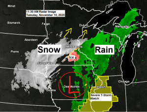
A powerful November storm will lift rapidly NE out of the Midwest and into eastern Lake Superior by early Wednesday morning. This is a classic November storm with a risk for severe thunderstorms in the warm air/east side of the low (yellow and dark green areas on map) while heavy snow and freezing rain occurs in the cold air/west side of the low (blue outlined areas on map)

Thanks for reading!
Tim
Leave a Reply