5:23 PM Tuesday – There’s been some changes to the winter weather headlines this afternoon as the National Weather Service in Duluth has upgraded some of the winter weather advisory to a winter storm warning.
Tonight’s storm will bring accumulating snow to much of northeast and east-central Minnesota and northwest Wisconsin, along with some freezing rain and sleet mainly in northwest Wisconsin. This will be a quick hitting storm, however, lasting roughly 6-8 hours.
Radar loop ending at ~5 PM Tuesday shows a blossoming of precipitation (mostly snow) south of Duluth late this afternoon as forcing/lift intensifies as a strong low pressure system and mid/upper trough lifts NE into the Northland. Note: One thing I’m noticing on radar are for bands of precipitation instead of one solid area of precip, this could affect snow totals just a bit (possibly a little lower than forecast) but will see how things play out thru the evening.
Source: https://weather.cod.edu/

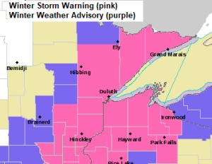
Winter Storm Warning in effect through early Wednesday morning including the cities of Aitkin, McGregor, Pine City, Hinckley, Moose Lake, Cloquet, Duluth, Hibbing, Cook, Two Harbors, Isabella, Silver Bay, Grand Marais, Superior, Solon Springs, Washburn, Bayfield, Ashland, Hurley, Siren, Danbury, Grantsburg, Minong, Spooner, Shell Lake, Hayward and Winter.
Winter Weather Advisory in effect through early Wednesday morning including the cities of Brainerd, Hill City, Grand Rapids, Orr, Crane Lake and Ely.
Plan on slippery road conditions in the warning and advisory areas tonight and Wednesday morning.
Source: https://www.weather.gov/dlh/

Links to road conditions
Minnesota https://new.511mn.org/
Wisconsin https://511wi.gov/
As is often the case with these winter storms there should be a sharp cutoff to the snow, and that line is expected to setup from roughly Walker to the Bigfork and International Falls area, but we could see that axis shift a little further east, possibly along a line from Walker to Hibbing up toward Cook and Crane Lake.
Should end up with 4 to 6 inches of snow in Duluth and Superior by early Wednesday morning.
Note: The daily snowfall record for November 10th at Duluth, Minnesota is 7.2″ set in 1998, this record is likely safe, but a top 5 snowiest November 10th looks likely.

18z NAM 3km model radar forecast thru 7 AM Wednesday.
Winter storm with snow, some sleet and freezing rain tonight, ending from SW-NE overnight.
Note: Snow is expected to end in Duluth and Superior around 2-4 AM Wednesday.
Source: https://weathermodels.com/

MD issued for much of central, eastern and southern Minnesota and far western Wisconsin thru 10 PM this evening regarding heavy snow and mix precipitation – Link to discussion https://www.spc.noaa.gov/products/md/md1783.html
Source: https://www.spc.noaa.gov/

A strong November storm today, with a severe side including a risk for a few tornadoes from southern Wisconsin to central Illinois through early this evening, while in the colder air its all about the snow, sleet and freezing rain. This system will lift rapidly NE while it impacts the Northland tonight.

As a strong mid/upper level low/trough heads northeast out of southwestern Minnesota this evening it will bring with it a period of intense atmospheric lift which will lead to a period of heavy snowfall in portions of northeast and east-central Minnesota into northwestern Wisconsin tonight.

Source: https://www.spc.noaa.gov/

Low pressure over southwest Wisconsin late this afternoon will deepen a bit as it lifts NE tonight (red line on map)

A couple satellite loops of today’s November storm, and this storm looks impressive on satellite imagery.
First loop is visible imagery.
Source: https://www.star.nesdis.noaa.gov/

And here’s a water vapor loop from today, Tuesday, November 10, 2020.

Thanks for reading!
Tim
Leave a Reply